
The Wai-iti River is in the north of the South Island of New Zealand. It flows northeast for 45 kilometres (28 mi) before combining with the Wairoa River to form the Waimea River. This flows into the southern end of Tasman Bay / Te Tai-o-Aorere near Richmond.
The Makatote River is a river of the centre of New Zealand's North Island. It flows west from the slopes of Mount Ruapehu, and from the Hauhungatahi Wilderness Area, before entering rough hill country, veering southwest and entering a gorge cut almost 100 m (330 ft) into the volcanic rocks. It joins with the waters of several smaller streams to become the Manganui o te Ao River, part of the Whanganui River system.
For the sawmill area of Mangapehi see Ellis and Burnand#Mangapehi
The Mangapu River is a river of the Waikato region of New Zealand's North Island. It has its sources in numerous streams which flow generally northwards from the King Country south of Te Kuiti, the longest of which is the Mangaokewa Stream. These streams join to form the Mangapu close to Te Kuiti, and from here the river flows north, passing close to the east of Waitomo Caves, where the Mangapu caves have the largest entrance in the North Island, before flowing into the Waipa River at Otorohanga.

The Mangatāwhiri River is a river of the Auckland and Waikato regions of New Zealand's North Island. It flows generally southwest from its sources in the Hunua Ranges southeast of Clevedon before flowing through a system of irrigation canals at the northern edge of the Waikato Plains close to the town of Pokeno. It reaches the Waikato River close to the township of Mercer.
The Mangaturuturu River is a river of the centre of New Zealand's North Island. One of the headwaters of the Manganui o te Ao River, it flows west from the slopes of Mount Ruapehu, joining with numerous other small rivers to become the Manganui o Te Ao 20 kilometres (12 mi) northwest of Ohakune. It has also been known as Sulphur River, or Sulphur Creek. In April 1975 a lahar raised the river to 2.1 m above its flood level. There were also lahars in 1969 and September 1995. Earlier lahars were around 8,500 and 10,500 years ago.
The Otahu River is a river of the Coromandel Peninsula, in the Waikato Region of New Zealand's North Island. It flows generally northeast from several streams with watersheds in the Coromandel Range, most notably the Wharekirauponga Stream. The Otahu reaches the sea immediately to the south of the town of Whangamatā.
The Tahaenui River is a river of the Hawke's Bay region of New Zealand's North Island. It flows generally southeast to reach Hawke Bay five kilometres west of Nuhaka.
The Waihora River is a river of the Gisborne Region of New Zealand's North Island. It flows generally west from its sources in rough hill country southwest of Tolaga Bay to reach the Waipaoa River at Te Karaka.

Ranana is a settlement 60 kilometres (37 mi) up the Whanganui River from Whanganui, New Zealand.
The Turanganui River is a river in the Wellington Region of New Zealand. It flows through the south Wairarapa from its source in the Aorangi Range to reach the Ruamahanga River shortly before the latter's outflow into Palliser Bay.
The Waiaua River is a river of the Taranaki Region of New Zealand's North Island. It flows southwest from the slopes of Mount Taranaki to reach the Tasman Sea at Opunake.
The Waikawau River is the name of two rivers of the Coromandel Peninsula in New Zealand's North Island. The more southerly flows generally west from its sources in the Coromandel Range, reaching the Firth of Thames 2 kilometres (1.2 mi) north of Tapu. The other flows south east off the Moehau Range to join the Pacific at Waikawau.

Pipiriki is a settlement in New Zealand, on the east bank of the Whanganui River, due west of the town of Raetihi and 79 kilometres (49 mi) upriver from Whanganui; it was originally on the opposite bank. It is the home of Ngāti Kura, a hapū of the Ngāti Ruanui iwi. It is also the location of the Paraweka Marae of the hapū Ngāti Kurawhatia of the iwi Te Āti Haunui-a-Pāpārangi.
Aramoho is a settlement on the Whanganui River, in the Whanganui District and Manawatū-Whanganui region of New Zealand's North Island. It is an outlying suburb of Whanganui.

Putiki is a settlement in the Whanganui District and Manawatū-Whanganui region of New Zealand's North Island, located across the Whanganui River from the Wanganui township. It includes the intersection of State Highway 3 and State Highway 4.

Ongarue is a rural community in the Ruapehu District and Manawatū-Whanganui region of New Zealand's North Island. It is located south of Te Kuiti and Waimiha, and north of Taumarunui. It is in meshblock 1041902, which had a population of 54 in 2013.
Koputaroa, Koputāroa or Kōputaroa is a rural community in the Horowhenua District and Manawatū-Whanganui region of New Zealand's North Island.

Whangaehu is a settlement in the Rangitikei District and Manawatū-Whanganui region of New Zealand's North Island.
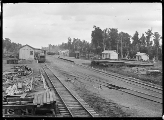
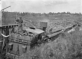
Pokaka was a station on the North Island Main Trunk line, in the Ruapehu District of New Zealand. It served the small village of Pokaka and lay to the south of Makatote Viaduct, the late completion of which held up opening of the station.
