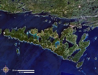
Manitoulin Island is an island in Lake Huron, located within the borders of the Canadian province of Ontario, in the bioregion known as Laurentia. With an area of 2,766 km2 (1,068 sq mi), it is the largest lake island in the world, large enough that it has over 100 inland lakes itself. In addition to the historic Anishinaabe and European settlement of the island, archeological discoveries at Sheguiandah have demonstrated Paleo-Indian and Archaic cultures dating from 10,000 BC to 2,000 BC.
The Metabetchouan River is a tributary of Lac Saint-Jean in the centre of the province of Quebec, Canada. The course of this river successively crosses the regional county municipalitys (MRC) of:
The Clyde River is a tributary of Lake Memphremagog, over 33.5 miles (54 km) long, in northern Vermont in the United States. It is the easternmost of the four major rivers in Orleans County. It is the most powerful of the four within Orleans County, powering several turbines at damsites. It is part of the Northern Forest Canoe Trail.
Manitoulin Streams Improvement Association is a not for profit group that rehabilitates streams, rivers and creeks on the largest lake island in the world Manitoulin Island, Ontario, Canada. They partner with the entire community, including farmers, fisherman, and local lake and fish associations. Their rehabilitation projects enhance water quality and the fisheries resource on Manitoulin Island and Lake Huron which is fed by the streams. These streams were once very productive for salmon and trout spawning, but have been destroyed by centuries of human land use practices.
Blue Jay Creek is a river on Manitoulin Island in Central Manitoulin and Tehkummah townships, Manitoulin District in northeastern Ontario, Canada and a tributary of Lake Huron.

The Tortue River is a river in the Côte-Nord administrative region, in the province of Quebec, Canada. The course of this river successively crosses the RCM of:
The Burgess Branch is a tributary of the Missisquoi River, crossing the municipalities of Eden and Lowell in Orleans County, Vermont, United States.

The Rivière aux Saumons is a tributary of Ashuapmushuan River, flowing in the unorganized territory of Lac-Ashuapmushuan and in the municipality of Saint-Félicien, in the Domaine-du-Roy, in the administrative region of Saguenay–Lac-Saint-Jean, in the province of Quebec, in Canada.
The rivière au Saumon is a tributary of the Saint-Jean River, flowing in the unorganized territory of Lac-Jérôme, in the Minganie Regional County Municipality, in the administrative region of Côte-Nord, in the province of Quebec in Canada.
The Rivière au Doré is a tributary of rivière aux Saumons, flowing in the municipalities of La Doré and the town of Saint-Félicien, in the Le Domaine-du-Roy Regional County Municipality, in the administrative region of Saguenay–Lac-Saint-Jean, in the province of Quebec, in Canada.
The Rivière aux Brochets is a tributary of the Ashuapmushuan River, flowing in the unorganized territory of Rivière-Mistassini, in the Maria-Chapdelaine Regional County Municipality, in the administrative region of Saguenay–Lac-Saint-Jean, in province of Quebec, in Canada.
The Saint-Jean North-East River is a tributary of the north shore of the Saint-Jean River, flowing in the unorganized territory of Lac-Jérôme, in the Minganie Regional County Municipality, in the administrative region of Côte-Nord, in province of Quebec, Canada.
The rivière du Grand Portage is a tributary of Chigoubiche River, flowing into the unorganized territory of Lac-Ashuapmushuan in the Le Domaine-du-Roy Regional County Municipality, in the administrative region of Saguenay–Lac-Saint-Jean, in province of Quebec, in Canada.
The Petite rivière Manitou is a tributary of Manitou River, flowing in the unorganized territory of Lac-Jérôme, in the Minganie Regional County Municipality, in the administrative region of Côte-Nord, in province of Quebec, in Canada.
The rivière aux Cailloux is a tributary of the Gulf of St. Lawrence, flowing in the municipality of L'Île-d'Anticosti, in the Minganie Regional County Municipality, in the administrative region of North Shore, in province of Quebec, in Canada.
The Sainte-Marie River is a tributary of the Gulf of St. Lawrence, flowing in the municipality of L'Île-d'Anticosti, in the Minganie Regional County Municipality, in the administrative region of Côte-Nord, in province of Quebec, in Canada.
The rivière Bec-Scie is a tributary of the Gulf of Saint Lawrence, flowing in the municipality of L'Île-d'Anticosti, in the Minganie Regional County Municipality, in the administrative region of Côte-Nord, in province of Quebec, in Canada.
The rivière aux Canards is a tributary of the Gulf of Saint Lawrence, flowing in the municipality of L'Île-d'Anticosti, in the Minganie Regional County Municipality, in the administrative region of Côte-Nord, in province of Quebec, in Canada.
La Petite Rivière is a tributary of the Gulf of St. Lawrence, flowing in the municipality of L'Île-d'Anticosti, in the Minganie Regional County Municipality, in the administrative region of Côte-Nord, in province of Quebec, in Canada.
The rivière à la Chute is a tributary of the Gulf of St. Lawrence, flowing in the municipality of L'Île-d'Anticosti, in the Minganie Regional County Municipality, in the administrative region of Côte-Nord, in province of Quebec, in Canada.

