Mannal

Last updated

Mannal
Mannal - geograph.org.uk - 312996.jpg
Houses in Mannal, adjacent to the coast
Argyll and Bute UK location map.svg
Red pog.svg
Mannal
Location within Argyll and Bute
OS grid reference NL9840
Council area
Lieutenancy area
Country Scotland
Sovereign state United Kingdom
Post town ISLE OF TIREE
Postcode district PA77
Police Scotland
Fire Scottish
Ambulance Scottish
UK Parliament
Scottish Parliament
List of places
UK
Scotland
56°27′36″N6°53′34″W / 56.4599°N 6.8928°W / 56.4599; -6.8928 Coordinates: 56°27′36″N6°53′34″W / 56.4599°N 6.8928°W / 56.4599; -6.8928

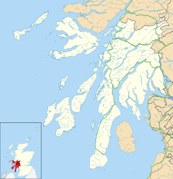
Mannal is a coastal hamlet on the west side of Hynish Bay, on the island of Tiree, Scotland. [1] The township of Mannal lies on the southwest corner of Tiree at the southern end of Hynish Bay between Hynish and Balemartine. Tiree is the most westerly island in the Inner Hebrides which lie off the west coast of Scotland.
Related Research Articles

<span class="mw-page-title-main">Argyll and Bute</span> Council area of Scotland

Argyll and Bute is one of 32 unitary authority council areas in Scotland and a lieutenancy area. The current lord-lieutenant for Argyll and Bute is Jane Margaret MacLeod. The administrative centre for the council area is in Lochgilphead at Kilmory Castle, a 19th-century Gothic Revival building and estate. The current council leader is Robin Currie, a councillor for Kintyre and the Islands.

<span class="mw-page-title-main">Inner Hebrides</span> Archipelago off the west coast of mainland Scotland

The Inner Hebrides is an archipelago off the west coast of mainland Scotland, to the south east of the Outer Hebrides. Together these two island chains form the Hebrides, which experience a mild oceanic climate. The Inner Hebrides comprise 35 inhabited islands as well as 44 uninhabited islands with an area greater than 30 hectares. Skye, Mull, and Islay are the three largest, and also have the highest populations. The main commercial activities are tourism, crofting, fishing and whisky distilling. In modern times the Inner Hebrides have formed part of two separate local government jurisdictions, one to the north and the other to the south. Together, the islands have an area of about 4,130 km2 (1,594 sq mi), and had a population of 18,948 in 2011. The population density is therefore about 4.6 inhabitants per square kilometre.

<span class="mw-page-title-main">Isle of Mull</span> Island off the coast of Scotland

The Isle of Mull or just Mull is the second-largest island of the Inner Hebrides and lies off the west coast of Scotland in the council area of Argyll and Bute.

<span class="mw-page-title-main">Argyll</span> Historic county in Scotland

Argyll, sometimes called Argyllshire, is a historic county and registration county of western Scotland.

<span class="mw-page-title-main">Coll</span> Island and parish in the Inner Hebrides, Scotland

Coll is an island located west of the Isle of Mull in the Inner Hebrides of Scotland. Coll is known for its sandy beaches, which rise to form large sand dunes, for its corncrakes, and for Breacachadh Castle. It is in the council area of Argyll and Bute.

Tiree is the most westerly island in the Inner Hebrides of Scotland. The low-lying island, southwest of Coll, has an area of 7,834 hectares and a population of around 650.

The Treshnish Isles are an archipelago of small islands and skerries, lying west of the Isle of Mull, in Scotland. They are part of the Inner Hebrides. Trips to the Treshnish Isles operate from Ulva Ferry, Tobermory, Ardnamurchan and Tiree.

<span class="mw-page-title-main">Calgary, Mull</span> Human settlement in Scotland

Calgary is a hamlet on the northwest coast of the Isle of Mull, in Argyll and Bute, Scotland, United Kingdom. The hamlet is within the parish of Kilninian and Kilmore. It was the origin of the name of Fort Calgary in Canada, which became the city of Calgary, Alberta.

Skerryvore is a remote island that lies off the west coast of Scotland, 11 nautical miles southwest of Tiree. Skerryvore Lighthouse is located on these rocks, built with some difficulty between 1838 and 1844 by Alan Stevenson.

<span class="mw-page-title-main">Scarinish</span> Human settlement in Scotland

Scarinish is the main village on the island of Tiree, in the Inner Hebrides of Scotland. It is located on the south coast of the island, between Hynish Bay to the southwest and Gott Bay to the northeast. The harbour was built in 1771. In 1961 it had a population of 103.

<span class="mw-page-title-main">Geography of Scotland</span> Geographical features of Scotland

The geography of Scotland is varied, from rural lowlands to unspoilt uplands, and from large cities to sparsely inhabited islands. Located in Northern Europe, Scotland comprises the northern third of the island of Great Britain as well as 790 surrounding islands encompassing the major archipelagos of the Shetland Islands, Orkney Islands and the Inner and Outer Hebrides.

<span class="mw-page-title-main">Tiree Airport</span> Airport in Crossapol Argyll and Bute

Tiree Airport is located 2.5 nautical miles north northeast of Balemartine on the island of Tiree in the Inner Hebrides off the west coast of Scotland. It is owned and maintained by Highlands and Islands Airports Limited.

<span class="mw-page-title-main">Loch Seaforth</span>

Loch Seaforth is a sea loch in the Outer Hebrides of Scotland. It consists of three distinct sections; the most seaward is aligned northwest–southeast, a middle section is aligned northeast–southwest and the inner and most northerly section is aligned east–west. The southern stretch of the loch seaward from Bowglass forms the boundary between Lewis and Harris and was until 1975 the boundary between the traditional counties of Ross and Cromarty and Inverness-shire. The settlement of Rhenigidale lies near the mouth of the loch whilst the settlement of Maaruig lies on Loch Maraig, an embayment on the western side of Loch Seaforth. Further settlement is found around the small bays at Ardvourlie opposite Seaforth Island which sits in the midst of the loch at the point where inland it turns towards the northeast. The crofting township of Arivruaich lies beside a further embayment known as Tob Cheann Tarabhaigh. The head of the loch is to be found 5 km further east at Ceann Shiphoirt. The loch forms the entire western coast of the relatively isolated Pairc peninsula.

Gunna is an island in the Inner Hebrides of Scotland.

<span class="mw-page-title-main">Hinba</span>

Hinba is an island in Scotland of uncertain location that was the site of a small monastery associated with the Columban church on Iona. Although a number of details are known about the monastery and its early superiors, and various anecdotes dating from the time of Columba of a mystical nature have survived, modern scholars are divided as to its whereabouts. The source of information about the island is Adomnán's late 7th-century Vita Columbae.

<span class="mw-page-title-main">Dùn Anlaimh</span>

Dùn Anlaimh, also known as Dùn Amhlaidh, and Eilean nan Cinneachan, is a crannog, located within Loch nan Cinneachan on the Inner Hebridean island of Coll. Upon the crannog there are the remains of walls and several buildings. These remains are not unlike those of other fortified islands found throughout the Outer Hebrides, and it is likely that Dùn Anlaimh dates from the late Middle Ages. According to local tradition on Coll, the fort was once the home of a Norse chieftain who was defeated in battle somewhere nearby. The early 20th century antiquary Erskine Beveridge considered it as one of the four most interesting fortifications, on Coll. The site of Dùn Anlaimh is located at grid reference NM18845684. The RCAHMS classifies the site as a 'crannog' and an 'island dwelling'.

Baithéne mac Brénaind was an Irish monk, one of Saint Columba's followers who accompanied him to Scotland around 563, and was the first successor of the abbacy of Iona. The Annals of Tigernach record his birth in 534, and his death was likely between 596 and 598 according also to the Annals of Ulster. Irish genealogical records indicate him to be the "son of Brendan, son of Fergus, son of Conall Gulban, son of Niall Noígiallach", thus being a member of the Cenél Conaill branch of the Northern Uí Néill, as the abbots of Iona following the death of Columba often were.

<span class="mw-page-title-main">Dùn an Achaidh</span>

Dùn an Achaidh, sometimes Anglicised as Dun Acha, is a dun located near the village of Acha on the Inner Hebridean island of Coll. It is considered the best preserved dun on the island. The site of Dùn an Achaidh is located at grid reference NM18335456. According to local tradition, the dun was the stronghold of, and named after, the son of a Norse king. The early 20th century antiquary Erskine Beveridge considered it as one of the four most interesting fortifications on Coll.

<span class="mw-page-title-main">Dùn Beic</span> Dun located on the Inner Hebridean island of Coll

Dùn Beic is a dun located on the Inner Hebridean island of Coll. It is located at grid reference NM15495644 and is thought to date to between 1000 BCE to 1000 CE. The etymology of the dun's name is uncertain; one possibility is that it could be made up of a personal name. The dun appears in local legend as being one of several fortresses held by Norsemen, who were defeated in battle against the ancestor of the Macleans of Coll. There have been several archaeological finds at Dùn Beic; these include pieces of flint, burnt bone, and fragments of incised pottery.

<span class="mw-page-title-main">Surfing in Scotland</span>

Surfing in Scotland is a minor sport. The water around Scotland is fairly cold, requiring a full wetsuit, although it is warmed by the Gulf Stream.

References

  1. "Mannal". Gazetteer for Scotland . Retrieved 30 December 2020.