Manton, Kentucky

Last updated
Manton
USA Kentucky location map.svg
Red pog.svg
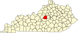
Manton
Location within the state of Kentucky
Usa edcp location map.svg
Red pog.svg
Manton
Manton (the United States)
Coordinates: 37°42′53″N85°23′7″W / 37.71472°N 85.38528°W / 37.71472; -85.38528 Coordinates: 37°42′53″N85°23′7″W / 37.71472°N 85.38528°W / 37.71472; -85.38528
Country United States
State Kentucky
County Washington
Elevation
530 ft (160 m)
Time zone UTC-5 (Eastern (EST))
  Summer (DST) UTC-4 (EDT)

Manton (formerly Blincoe) is an unincorporated community in the central part of the U.S. state of Kentucky, located on the western edge of Washington County near the intersection of Marion, Nelson, and Washington counties. It was founded at least before 1844, when Holy Rosary Church was founded. The cornerstone for the present church was laid November 2, 1844. [1] Holy Rosary, a mission church, is a brick building on Hardin's Creek close to the Beech Fork River. Rev. Victor Francis O'Daniel O.P.M. mentions in his book "A Light Of The Church In Kentucky" (copyright 1932) on page 140 that a station "... was possibly that of Wilfred Fields, where now stands Holy Rosary Church, Manton (or Blincoe)". [2]

Contents

This village was once known as Blincoe as is identified as such in the 1896 Kentucky Gazetteer . Richard Blincoe was a resident at that time. It was known as Blincoe until (at least) the mid-1900s, as it appears on as such on the 1949 official Kentucky highway map for Washington County. [3] Derivation of the name of this town has been attributed to the surnames of William Frederick Mandt and his wife, Mary Ann Harrington; however, the Kentucky town and U.S.Post Office named in their honor was Manton, Floyd County, Kentucky, ZIP Code (now inactive) 41648. The Mandt Family of Manton, Floyd County, were generous supporters of Catholic religious and educational interests in the region of Nelson and Washington Counties in the early-to-mid-Twentieth Century, and it has been suggested that Blincoe was redesignated as "Manton" in recognition of their support. However, Mr. and Mrs. Mandt were married in 1894, and any appearance of the name "Manton" prior to that time is not attributable to their family.

Newton's Grocery has been located at this site for over 80 years. [4] Once a general store serving the area and community, it is now more like a convenience store.

Geography

Manton is located at (37.714722, -85.35827). [5] The elevation is 530 feet (160 m) above sea level. The community is located along Route 605, near where the Cisselville road intersects. It is a few miles north of Loretto where Maker's Mark whiskey is distilled.

History

There was a station house on the Beech Fork, a small river, where farmers would store their cattle and produce. In the springtime these waters would flood, providing a waterway which lead first to the Salt River, then to the Ohio River and thence by flatboat the boatsmen could make their way to New Orleans.

Some companies of men from the Tenth Kentucky Infantry were mustered into Union service having come from the village of Manton. [6] Most of the men from the Manton area were in Company G.

John Hunt Morgan, the Confederate raider, passed through this area on some of his raids into Kentucky. The town is also mentioned in the biography "Three Years in the Saddle – the Life and Confession of Henry C. Magruder" - "The original 'Sue Munday'" - "The Scourge of Kentucky".

The small community was once home to a distillery of Kentucky Bourbon named Price and Thompson Distilleries, which closed in 1894. [7]

Related Research Articles

Bourbon whiskey Type of American whiskey, a barrel-aged distilled spirit made primarily from corn

Bourbon whiskey is a type of American whiskey, a barrel-aged distilled spirit made primarily from corn. The name ultimately derives from the French Bourbon dynasty, although the precise inspiration for the whiskey's name is uncertain; contenders include Bourbon County in Kentucky and Bourbon Street in New Orleans, both of which are named after the dynasty. Bourbon has been distilled since the 18th century. The name "Bourbon" was not applied until the 1850s, and the Kentucky etymology was not advanced until the 1870s. Although bourbon may be made anywhere in the United States, it is strongly associated with the American South and with Kentucky in particular. As of 2014, distillers' wholesale market revenue for bourbon sold within the U.S. was about $2.7 billion, and bourbon made up about two-thirds of the $1.6 billion of U.S. exports of distilled spirits. According to the Distilled Spirits Council of the United States, in 2018 U.S. distillers derived $3.6 billion in revenue from bourbon and Tennessee whiskey sold in the United States.

Frankfort, Kentucky Capital of Kentucky

Frankfort is the capital city of the Commonwealth of Kentucky and the seat of Franklin County. It is a home rule-class city in Kentucky; the population was 25,527 at the 2010 census. Located along the Kentucky River, Frankfort is the principal city of the Frankfort, Kentucky Micropolitan Statistical Area, which includes all of Franklin and Anderson counties.

Washington County, Kentucky U.S. county in Kentucky

Washington County is a county located in the U.S. state of Kentucky. As of the 2010 census, the population was 11,717. Its county seat is Springfield. The county is named for George Washington.

Daviess County, Kentucky U.S. county in Kentucky

Daviess County ( "Davis"), is a county in Kentucky. As of the 2010 census, the population was 96,656. Its county seat is Owensboro. The county was formed from part of Ohio County on January 14, 1815.

Clark County, Kentucky U.S. county in Kentucky

Clark County is a county located in the U.S. state of Kentucky. As of the 2010 census, the population was 35,613. Its county seat is Winchester. The county was created in 1792 from Bourbon and Fayette counties and is named for Revolutionary War hero George Rogers Clark.

Bourbon County, Kentucky U.S. county in Kentucky

Bourbon County is a county located in the U.S. state of Kentucky. As of the 2010 census, the population was 19,985. Its county seat is Paris.

Shively, Kentucky City in Kentucky, United States

Shively is a home rule-class city in Jefferson County, Kentucky, United States, and a suburb of Louisville within the Louisville Metro government. As of the 2010 census, the city's population was 15,264, reflecting an increase of 107 (+0.7%) from 15,157 in 2000.

Bardstown, Kentucky City in Kentucky, United States

Bardstown is a home rule-class city in Nelson County, Kentucky, United States. The population was recorded as 11,700 by the 2010 census. It is the county seat of Nelson County. It is named for the pioneering Bard brothers. David Bard obtained a 1,000 acres (400 ha) land grant in 1785 in what was then Jefferson County, Virginia, from Governor Patrick Henry. William Bard surveyed and platted the town. It was originally chartered as Baird's Town in 1788, and has been known as Beardstown, and Beards Town.

Barton Brands, Ltd. was a company that produced a variety of distilled beverages and liqueurs and is now part of the Sazerac Company, which is headquartered in New Orleans, Louisiana, and has its principal offices in Louisville, Kentucky. The Barton distillery, currently known as the Barton 1792 distillery, was originally established in 1879, and is located in Bardstown, Kentucky.

The Beech Fork, or Beech Fork River, is a 112-mile-long (180 km) river in central Kentucky in the United States. It is a tributary of the Rolling Fork of the Salt River, with its waters flowing eventually to the Ohio River and ultimately the Mississippi River.

A. Smith Bowman Distillery United States historic place

The A. Smith Bowman Distillery is a distillery that was originally based on the Bowman family's 7,200-acre Sunset Hills Farm in Fairfax County, Virginia, United States, in what later became the planned community of Reston. The distillery was founded in 1934 on the day after the end of Prohibition, by Abram Smith Bowman and his sons, Abram Smith, Jr., and DeLong. From the time of its founding until the 1950s, it was the only legal whiskey distillery in the Commonwealth of Virginia. The primary brands produced by the distillery were the Virginia Gentleman and Fairfax County bourbon whiskeys. In February 1988, it relocated to Spotsylvania County, near Fredericksburg, into a former FMC Corp. cellophane plant at One Bowman Drive, where operation continues as a microdistillery owned by the Sazerac Company.

Washington is a neighborhood of the city of Maysville located near the Ohio River in Mason County in the U.S. state of Kentucky. It is one of the earliest settlements in Kentucky and also one of the earliest American settlements west of the Appalachian Mountains. It played a significant role in the lead-up to the Civil War, producing two civil war generals and an escaped slave whose legal case established Canada as a safe haven for escaping slaves. It also provided the site where Harriet Beecher Stowe witnessed a slave auction. It has since been annexed by Maysville, and is sometimes now referred to as Old Washington. The community is in Area 606 served by the 759 exchange.

Holy Rosary Church (Manton, Kentucky) United States historic place

Holy Rosary Church was a parish erected in 1844 in the small community of Manton in Washington County, Kentucky, United States. The church was built under the direction of the Dominicans.

Neatsville, Kentucky Unincorporated community in Kentucky, United States

Neatsville is an unincorporated community in Adair County, in the U.S. state of Kentucky. It is located at the junction of Kentucky Route 206 and Kentucky Route 76. Its elevation is 705 feet (215 m). For unknown reasons, the town's name was spelled as Neetsville from 1876 until 1886, when the town's post office closed. In its early history from around the 1810s to 1900, Neatsville progressively grew to become a well-established, incorporated town. It has been relocated twice through the years, once due to flooding circa 1900–1902, which decimated the town, and once in the 1960s when the Green River was impounded to make way for the Green River Reservoir.

Athertonville, Kentucky Unincorporated community in Kentucky, United States

Athertonville is an unincorporated community located in LaRue County, Kentucky, United States.

Tyrone, Kentucky Unincorporated community in Kentucky, United States

Tyrone is an Ghost town located in Anderson County, Kentucky, United States. It is located east of Lawrenceburg along the Kentucky River.

Flippin, Kentucky Unincorporated community in Kentucky, United States

Flippin is an unincorporated community located in Monroe County, Kentucky, United States. A small residential village is located on Highway 249, approximately 3.6 miles (5.8 km) south of the Monroe-Barren County line. The village and community surround the intersection of Highway 249, Highway 678, and Highway 100. Flippin is situated northwest of Gamaliel, west of Tompkinsville, and east of Fountain Run. Flippin's post office (42132) closed in 1964.

Stitzel–Weller Distillery

Stitzel–Weller Distillery is a former distillery located in Shively, a suburb of Louisville, Kentucky. It was founded in 1935 and closed in 1972. It produced a number of notable brands, and since 2014 it has served as a public tourism site for Bulleit Bourbon, as part of the Kentucky Bourbon Trail.

Wattie Boone

Wattie Boone, was a pioneer distiller. He was a relative of Daniel Boone and built the first distillery in the area of Knob Creek in LaRue County. Historians agree that Boone was one of the first to be documented producing bourbon in Kentucky in 1776. According to local folklore the father of Abraham Lincoln accepted a job at the Boone Distillery in 1814.

References

  1. "Holy Rosary Catholic Church Cissellville Road Manton". usgennet.org.
  2. O'Daniel, Victor Francis (1932). "10". A Light Of The Church Of Kentucky (First ed.). Washington, D.C.: The Dominica. p. 140.
  3. "Archived copy". Archived from the original on 2007-02-11. Retrieved 2009-02-17.CS1 maint: archived copy as title (link) (map as .tiff file)
  4. http://www.thespringfieldsun.com/z_2007-07-25/front/story_4.asp%5B%5D
  5. "US Gazetteer files: 2010, 2000, and 1990". United States Census Bureau. 2011-02-12. Retrieved 2011-04-23.
  6. "10th Infantry (A-E) Civil War: Mercer Co. Ky". rootsweb.com.
  7. Bardstown: Hospitality, History and Bourbon, Dixie Hibbs, Arcadia Publishing Company (2002), p 109