
Gloucester County is a county in the U.S. state of New Jersey. As of the 2020 census, the county was the state's 14th-most populous county with a population of 302,294, its highest decennial count ever and an increase of 14,006 (+4.9%) from the 288,288 counted in the 2010 census, which in turn represented an increase of 33,615 (+13.2%) from the 2000 census population of 254,673. Its county seat is Woodbury. The county is part of the South Jersey region of the state.
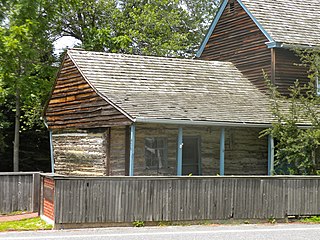
Gibbstown is an unincorporated community and census-designated place (CDP) located within Greenwich Township, in Gloucester County, in the U.S. state of New Jersey. As of the 2010 U.S. census, the CDP's population was 3,739. Gibbstown is the location of C. A. Nothnagle Log House, purportedly the oldest house in New Jersey and the oldest surviving log house in the U.S., dating to around 1638.

Glassboro is a borough within Gloucester County, in the U.S. state of New Jersey, within the Philadelphia metropolitan area. As of the 2020 United States census, the borough's population was 23,149, its highest decennial count ever and an increase of 4,570 (+24.6%) from the 18,579 recorded at the 2010 census, which in turn had reflected a decline of 489 (−2.6%) from the 19,068 counted in the 2000 census. Much of the recent and projected growth in Glassboro have been attributed to the growth trajectory of Rowan University, founded in 1923 and formerly known as Glassboro State College. Glassboro and surrounding Gloucester County constitute part of South Jersey.
Greenwich Township is a township in Gloucester County, in the U.S. state of New Jersey. As of the 2020 United States census, the township's population was 4,917, an increase of 18 (+0.4%) from the 2010 census count of 4,899, which in turn reflected an increase of 20 (+0.4%) from the 4,879 counted in the 2000 census.

Harrison Township is a township in Gloucester County in the U.S. state of New Jersey. As of the 2020 United States census, the township's population was 13,641, an increase of 1,224 (+9.9%) from the 2010 census count of 12,417, which in turn reflected an increase of 3,629 (+41.3%) from the 8,788 counted in the 2000 census.

Mantua Township is a township within Gloucester County in the U.S. state of New Jersey, within the Philadelphia metropolitan area. As of the 2020 United States census, the township's population was 15,235, its highest decennial count ever and an increase of 18 (+0.1%) from the 15,217 recorded at the 2010 census, which in turn reflected an increase of 1,000 (+7.0%) from the 14,217 counted in the 2000 census. Mantua and surrounding Gloucester County constitute part of South Jersey.

Paulsboro is a borough situated on the banks of the Delaware River in Gloucester County, in the U.S. state of New Jersey, within the Philadelphia metropolitan area. As of the 2020 United States census, the borough's population was 6,196, an increase of 99 (+1.6%) from the 6,097 recorded at the 2010 census, which in turn had reflected a decline of 63 (−1.0%) from the 6,160 counted in the 2000 census. Paulsboro and surrounding Gloucester County constitute part of South Jersey.

Pitman is a borough in Gloucester County, in the U.S. state of New Jersey. As of the 2020 United States census, the borough's population was 8,780, a decrease of 231 (−2.6%) from the 2010 census count of 9,011, which in turn reflected a decline of 320 (−3.4%) from the 9,331 in the 2000 census. The borough was named for Rev. Charles Pitman, a Methodist minister.

West Deptford Township is a township in Gloucester County, in the U.S. state of New Jersey. As of the 2020 United States census, the township's population was 22,197, an increase of 520 (+2.4%) from the 2010 census count of 21,677, which in turn reflected an increase of 2,309 (+11.9%) from the 19,368 counted in the 2000 census.
Sewell is a census-designated place (CDP) and unincorporated community within Mantua Township and Washington Township in Gloucester County, in the U.S. state of New Jersey, within the Philadelphia metropolitan area. As of the 2020 United States census, the CDP's population was 3,346. The CDP was named after United States Senator William Joyce Sewell. The community is served as U.S. Postal Service ZIP Code 08080. Sewell is home to Rowan College of South Jersey.
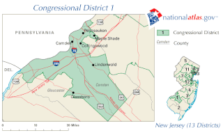
New Jersey's 1st congressional district is a congressional district in the U.S. state of New Jersey. The district, which includes Camden and South Jersey suburbs, has been represented by Democrat Donald Norcross since November 2014. It is among the most reliably Democratic districts in New Jersey, as it is mainly made up of Democratic-dominated Camden County.

Glassboro High School is a comprehensive community public high school that serves students in ninth through twelfth grades from Glassboro, in Gloucester County, in the U.S. state of New Jersey. It is the sole secondary school of the Glassboro Public Schools.

Paulsboro High School is a comprehensive community six-year public high school that serves students in seventh through twelfth grade from Paulsboro, in Gloucester County, in the U.S. state of New Jersey. It is the sole secondary school of the Paulsboro Public Schools.

Carpenter's Landing was a mercantile settlement located at the head of sloop navigation on Mantua Creek in Mantua Township in Gloucester County, New Jersey.
Thomas Carpenter was an early American glassmaker and devout Quaker who, at significant spiritual and personal risk, found an important way to assist the American Revolutionary War, serving in the militia and the New Jersey Continental Line as what would today be called a logistics officer and earning the title of "Fighting Quaker." After the war, he contributed significantly to the rise of New Jersey glass production.

New Jersey's 3rd legislative district is one of 40 in the state. As of the 2021 apportionment the district covers the Cumberland County municipalities of Deerfield Township, Greenwich Township, Hopewell Township, Shiloh Borough, Stow Creek Township, and Upper Deerfield Township; the Gloucester County municipalities of Clayton, East Greenwich Township, Elk Township, Glassboro, Greenwich Township, Harrison Township, Logan Township, Mantua Township, National Park, Paulsboro, Pitman, South Harrison Township, Swedesboro, Wenonah Borough, West Deptford Township, Westville, and Woolwich Township, as well as all Salem County municipalities, including Alloway Township, Carneys Point Township, Elmer, Elsinboro Township, Lower Alloways Creek Township, Mannington Township, Oldmans Township, Penns Grove, Pennsville Township, Pilesgrove Township, Pittsgrove Township, Quinton Township, Salem, Upper Pittsgrove Township and Woodstown.
The Port of Paulsboro is located on the Delaware River and Mantua Creek in and around Paulsboro, in Gloucester County, New Jersey, approximately 78 miles (126 km) from the Atlantic Ocean. Traditionally one of the nation's busiest for marine transfer operations, notably for crude oil and petroleum products, such as jet fuel and asphalt, it is a port of entry with several facilities within a foreign trade zone.

Penns Grove Secondary is a rail freight line in the Delaware Valley in the southwestern part of New Jersey. Part of Conrail's South Jersey/Philadelphia Shared Assets it runs for approximately 20 miles (32 km) between its southern terminus at Penns Grove and Woodbury at the north where it joins the Vineland Secondary about 8.5 miles (13.7 km) south of Pavonia Yard in Camden. At its southern end the Deepwater Point Running Track continues another 3.7 miles (6 km) through Carneys Point to Deepwater.

The Glassboro–Camden Line (GCL) is a planned 18-mile (29 km) diesel multiple unit (DMU) light rail system to be located in South Jersey.
