Manville, South Carolina | |
|---|---|
 Manville  Manville | |
| Coordinates: 34°09′35″N80°17′51″W / 34.15972°N 80.29750°W [1] | |
| Country | United States |
| State | South Carolina |
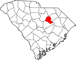
| County | Lee |
| Area | |
• Total | 2.72 sq mi (7.04 km2) |
| • Land | 2.72 sq mi (7.04 km2) |
| • Water | 0 sq mi (0.00 km2) |
| Elevation | 220 ft (67 m) |
| Population | |
• Total | 471 |
| • Density | 173.2/sq mi (66.88/km2) |
| Time zone | UTC-5 (Eastern (EST)) |
| • Summer (DST) | UTC-4 (EDT) |
| ZIP Code | 29010 (Bishopville) |
| Area codes | 803/839 |
| FIPS code | 45-44395 |
| GNIS feature ID | 2812973 [1] |
Manville is an unincorporated community and census-designated place (CDP) in Lee County, South Carolina, United States. It was first listed as a CDP prior to the 2020 census [1] with a population of 471. [4]
Contents
The CDP is in central Lee County along U.S. Route 15, 5 miles (8 km) southwest of Bishopville, the county seat, and 17 miles (27 km) north of Sumter. South Carolina Highway 441 has its northeastern terminus at US 15 just south of the CDP; Highway 441 leads southwest 19 miles (31 km) to U.S. Routes 76 and 378 next to Shaw Air Force Base west of Sumter. Scape Ore Swamp, a tributary of the Black River, forms the western border of the community.