Pendleton County is a county located in the U.S. state of West Virginia. As of the 2010 census, the population was 7,695, making it the fifth-least populous county in West Virginia. Its county seat is Franklin. The county was created by the Virginia General Assembly in 1788 from parts of Augusta, Hardy, and Rockingham Counties and was named for Edmund Pendleton (1721–1803), a distinguished Virginia statesman and jurist. Pendleton County was strongly pro-Confederate during the American Civil War; however, there were pockets of Union support.

Marla Ann Maples is an American actress and television personality. Maples was the second wife of Donald Trump Sr, later the 45th president of the United States. They married in 1993 and divorced in 1999.

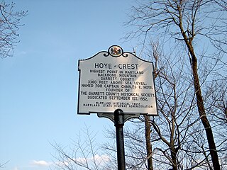
Backbone Mountain is a ridge of the Allegheny Mountains of the central Appalachian Mountain Range. It is situated in the U.S. states of West Virginia and Maryland and forms a portion of the Eastern Continental Divide. In the state of Maryland, Backbone Mountain reaches an elevation of 3,360 feet or 1,024 metres, making it Maryland’s highest point.

Spruce Knob, at 4,863 feet (1,482 m), is the highest point in the state of West Virginia and the summit of Spruce Mountain, the highest peak in the Allegheny Mountains.
Mapleview or Maple View may refer to:

Big Run is a 4.4-mile-long (7.1 km) tributary stream of the South Branch Potomac River, belonging to the Potomac River and Chesapeake Bay watersheds. Big Run flows through the city of Romney and the campus of the West Virginia Schools for the Deaf and Blind in Hampshire County, West Virginia. The stream is known by local residents as Town Run and Town Creek.
Edward Retz "Eddie" Maple is a retired American thoroughbred horse racing jockey. One of eight brothers and sisters, he was an older brother to jockey Sam Maple who won more than 2,500 races. He began riding horses at age 12 and won his first race as a professional at 17. He went on to be one of the top jockeys in the United States and a National Hall of Fame inductee.

Ice Mountain is a mountain ridge and algific talus slope that is part of a 149-acre (60 ha) preserve near the community of North River Mills in Hampshire County, West Virginia, United States. It was designated a National Natural Landmark in 2012.

North Fork Mountain is a quartzite-capped mountain ridge in the Ridge and Valley physiographic province of the Allegheny Mountains of eastern West Virginia, USA. Kile Knob, at 4,588 feet, is the mountain's highest point, and Panther Knob and Pike Knob are nearly as high.

Maple Leaf Square is a multi-use complex and public square located in the South Core neighbourhood of Toronto, Ontario, Canada. It is located to the west of the Scotiabank Arena on the former Railway Lands. The $500 million development was jointly developed by Cadillac Fairview, Lanterra and Maple Leaf Sports & Entertainment (MLSE), who own the nearby Scotiabank Arena. The complex has 1,800,000 square feet (170,000 m2) of usable space covering 2.1 acres (0.85 ha) on one city block.

Eglon is an unincorporated community in Preston County, West Virginia, United States. Its elevation is 2,628 feet (801 m). Although it is unincorporated, it has a post office, with the ZIP code of 26716.

Maplewood is an unincorporated community in Fayette County, West Virginia, United States. Maplewood is located on West Virginia Route 41 6.5 miles (10.5 km) northwest of Meadow Bridge.

Maple Acre is an unincorporated community in Mercer County, West Virginia, United States. Maple Acre is located near U.S. Route 19 3.5 miles (5.6 km) south-southwest of Princeton.

The natural environment of Virginia encompasses the physical geography and biology of the U.S. state of Virginia. Virginia has a total area of 42,774.2 square miles (110,784.67 km2), including 3,180.13 square miles (8,236.5 km2) of water, making it the 35th-largest state by area. Forests cover 65% of the state, wetlands and water cover 6% of the land in the state, while 5% of the state is a mixture of commercial, residential, and transitional.

The North River is a tributary of the Cacapon River, belonging to the Potomac River and Chesapeake Bay watersheds. The river is located in Hampshire and Hardy counties in the U.S. state of West Virginia's Eastern Panhandle. The mouth of the North River into the Cacapon is located at Forks of Cacapon. From its headwaters to its mouth, the North River spans 52.4 miles (84.3 km) in length.

Maple Meadow is an unincorporated community in Raleigh County, West Virginia.

Maple Fork is an unincorporated community in Raleigh County, West Virginia.

Maple Run is an unincorporated community in Taylor County, West Virginia.

Maple is an unincorporated community in Monongalia County, West Virginia.
Twin Sugars is a summit in West Virginia, in the United States. With an elevation of 3,602 feet (1,098 m), Twin Sugars is the 177th highest summit in the state of West Virginia.


