
Mercer County is a county in Southern West Virginia on the southeastern border of the U.S. state of West Virginia. At the 2020 census, the population was 59,664. Its county seat is Princeton. The county was originally established in the State of Virginia by act of its General Assembly on March 17, 1837, using lands taken from Giles and Tazewell counties.

Matoaka is a census-designated place in Mercer County, West Virginia, United States. The population was 173 at the 2020 census. It is part of the Bluefield, WV-VA micropolitan area which has a population of 100,093. This town is named for Chief Powhatan's daughter Matoaka who was better known by her nickname "Pocahontas". Matoaka became an unincorporated town when it voted to dissolve its charter in May 2018.

Points is an unincorporated community in Hampshire County in the U.S. state of West Virginia. According to the 2000 census, the Points community has a population of 478.
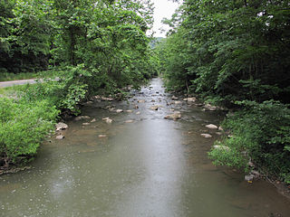
The East River is a tributary of the New River, 24 miles (39 km) long, in southern West Virginia and southwestern Virginia in the United States. Via the New, Kanawha and Ohio rivers, it is part of the watershed of the Mississippi River, draining an area of 76.4 square miles (198 km2) in the Ridge-and-Valley Appalachians.

Shenandoah Junction is a census-designated place (CDP) in Jefferson County in the U.S. state of West Virginia's Eastern Panhandle. As of the 2010 census, Shenandoah Junction had a population of 703. It is located between Kearneysville, WV and Charles Town, WV off WV 9. Shenandoah Junction is home to Jefferson High School and West Virginia's oldest surviving wood-frame structure, the Peter Burr House, built around 1751. The land where Shenandoah Junction was built was part of the 392 acres (1.59 km2) granted by Lord Fairfax to Lewis Neil. The town was originally called Neil's, but the name was changed to Shenandoah Junction in 1881.
Pageton is a census-designated place (CDP) in McDowell County, West Virginia, United States. As of the 2010 census, its population was 187. Pageton is located on the Tug Fork Branch of the Norfolk and Western Railway, along the Pocahontas seam of rich bituminous coal. Pageton is located on State Route 161 between Thorpe and Anawalt.
Sandyville is an unincorporated community in north central Jackson County, West Virginia, United States. It lies close to the left fork of Sandy Creek, nestled in the hills between Ravenswood and Ripley. It has a population of 1,721 and an average household income of $41,122.

Quick is a small unincorporated community in Kanawha County, West Virginia, United States. It is located along Indian Creek Road. The community is where Whitoak Fork and Blue Creek come together and meet. It is also where the abandoned railroad that follows Blue Creek joins the road, and follows it all the way to the community of Hitop, along Pond Fork. Its post office is closed.

Lashmeet is a census-designated place (CDP) in western Mercer County, West Virginia, United States. It lies along West Virginia Route 10 northwest of the city of Princeton, the county seat of Mercer County. Although Lashmeet is unincorporated, it has a post office, with the ZIP code of 24733. As of the 2010 census, its population was 479.
Beards Fork is a census-designated place (CDP) and coal town in Fayette County, West Virginia, United States that was founded as a coal town. As of the 2010 census, its population was 199.
Elgood is an unincorporated community in Mercer County, West Virginia, United States. Elgood is 5 miles (8.0 km) east-southeast of Athens.
Key Rock is an unincorporated community in Wyoming County, West Virginia, United States. The community is home to the Coon Fork Church congregation and the Lester Family Cemetery.
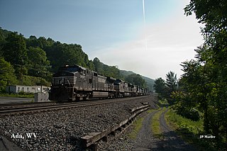
Ada is an unincorporated community in Mercer County, West Virginia, United States. Ada is located on West Virginia Route 112, 4.5 miles (7.2 km) east-northeast of Bluefield.
Verdunville is an unincorporated community and census-designated place (CDP) in Logan County, West Virginia, United States. It is 3.5 miles (5.6 km) west of Logan, the county seat. Verdunville has a post office with ZIP code 25649. The Verdunville CDP includes the neighboring community of Shegon. As of the 2010 census, the total CDP population was 687.
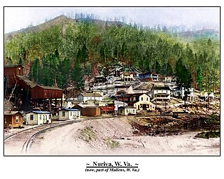
Nuriva is an unincorporated community in Wyoming County, West Virginia, United States. It was also known as Trace Fork and Tracoal. Its post office is closed.
Crystal is an unincorporated community in Mercer County, West Virginia, United States. Crystal is located on Crane Creek and County Route 11, 7.6 miles (12.2 km) north-northwest of Bluefield.
Widemouth was an unincorporated community and coal town located in Mercer County, West Virginia.
Edwight is an unincorporated community in Raleigh County, West Virginia. Edwight was also known as Launa.

Smokeless is an unincorporated community in Mercer County, West Virginia, United States.
Coopers is a neighborhood of Bramwell, Mercer County, West Virginia, United States. It was named after John Cooper, a figure in the local mining industry.

