Related Research Articles

Union County is a county located on the central southern border of the U.S. state of Arkansas. As of the 2020 census, the population was 39,054. The county seat is El Dorado. The county was formed on November 2, 1829, and named in recognition of the citizens' petition for a new county, which said that they were petitioning "in the spirit of Union and Unity." The county is directly adjacent to the south to Union Parish in the state of Louisiana.

Saline County is located in the U.S. state of Arkansas. As of the 2020 census, the population was 123,416. Its county seat and largest city is Benton. Saline County was formed on November 2, 1835, and named for the salt water (brine) springs in the area, despite a differing pronunciation from saline. Until November 2014, it was an alcohol prohibition or dry county.

Pulaski County is a county in the U.S. state of Arkansas. With a population of 399,125 as of the 2020 United States Census, it is the most populous county in Arkansas. The county is included in the Little Rock–North Little Rock–Conway metropolitan area. Its county seat is Little Rock, which is also Arkansas's capital and largest city.
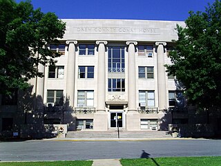
Drew County is a county located in the southeast region of the U.S. state of Arkansas. As of the 2020 census, the population was 17,350. The county seat and largest city is Monticello. Drew County was formed on November 26, 1846, and named for Thomas Drew, the third governor of Arkansas.
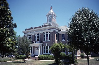
Cleveland County is a county located in the U.S. state of Arkansas. Its population was 7,550 at the 2020 U.S. census. The county seat and largest city is Rison.

Cleburne County is a county located in the U.S. state of Arkansas. As of the 2020 census, the population was 24,711. The county seat and most populous city is Heber Springs. The county was formed on February 20, 1883, as the last of Arkansas's 75 counties to be formed. It is named for Confederate Major-General Patrick Cleburne. Cleburne is an alcohol prohibition or dry county.

Bradley County is a county located in the U.S. state of Arkansas. As of the 2020 census, the population was 10,545. The county seat is Warren. It is Arkansas's 43rd county, formed on December 18, 1840, and named for Captain Hugh Bradley, who fought in the War of 1812.

Ashley County is a rural South Arkansas county with a culture, economy, and history based on timber and agriculture. Created as Arkansas's 52nd county on November 30, 1848, Ashley County has seven incorporated municipalities, including Hamburg, the county seat and Crossett, the most populous city. The county is also the site of numerous unincorporated communities and ghost towns. The county is named for Chester Ashley, a prominent lawyer in the Arkansas Territory and U.S. senator from the state from 1844 to 1848.

South Arkansas lies within the southernmost portions of Arkansas Gulf Coastal Plain and Delta regions. It encompasses the lower 15 counties of the state.
There are several lakes named Mud Lake within the U.S. state of Arkansas.

The Arkansas Timberlands is a region of the U.S. state of Arkansas generally encompassing the area south of the Ouachita Mountains, south of Central Arkansas and west of the Arkansas Delta. With several different definitions in use by various state agencies, the Arkansas Timberlands is essentially a region known for dense pine and cypress forests covering hilly terrain and lining numerous rivers. Modern settlement created a significant logging industry and subsequent clearance agriculture which provided the basis of the local economy until the discovery of petroleum. Local tourism is largely based on the popularity of deer hunting and bass fishing. Attractions there include Marks' Mills Battleground Historical Monument, Jenkins' Ferry Battleground Historical Monument, Overflow National Wildlife Refuge, Felsenthal National Wildlife Refuge, South Arkansas Arboretum, Arkansas Museum of Natural Resources, White Oak Lake State Park, Poison Springs Battleground State Park, Millwood State Park, and Pond Creek National Wildlife Refuge. The Arkansas Timberlands is the birthplace of former President of the United States Bill Clinton.

Lamine Township is one of 14 civil townships in Cooper County, in the U.S. state of Missouri. Twenty-two of Missouri's 114 counties, including Cooper County, have civil township governments. The other 92 counties have townships which are geographical but not governmental (civil). According to the 1860 Census, the population of Lamine Township was 830 . As of the 2020 Census, Lamine Township's population was 257.
L’Aigle Creek is a waterway in Bradley County, Arkansas. It is 44.2 miles long. It flows into the Saline River. The Saline River flows into the Ouachita River.

Banner Township is a township in Ashley County, Arkansas, United States. Its total population was 158 as of the 2010 United States Census, a decrease of 7.6 percent from 171 at the 2000 census.

Banner Township is a township in Saline County, Arkansas, United States. Its total population was 6,790 as of the 2010 United States Census, an increase of 22.85 percent from 5,527 at the 2000 census.
Bayou Township is a township in Ashley County, Arkansas, United States. Its population was 55 at the 2010 United States Census, a decrease of 5.17 percent from 58 at the 2000 census.

Bayou Township is a township in Baxter County, Arkansas, United States. Its total population was 360 as of the 2010 United States Census, a decrease of 11.76 percent from 408 at the 2000 census.
Beaver Township is a township in Saline County, Arkansas, United States. Its total population was 3,211 as of the 2010 United States Census, an increase of 20.22 percent from 2,671 at the 2000 census.
Mount Elba is an unincorporated community in Cleveland County, Arkansas, United States. The land belonged to the Quapaw people, but it was opened to American settlement by a treaty in 1824. By the 1830s, a settlement was set up on the east bank of the Saline River on the road between Pine Bluff and Camden. Ferry service began in 1845 and a post office was opened in 1847. Mount Elba was a bustling community by the time of the American Civil War and a skirmish was fought there on March 30, 1864 as part of the Camden Expedition. The conflict badly damaged the town and the surrounding area. With the establishment of railroads, the importance of river traffic declined and the town's population dwindled. Only a few residences remain in the area.
References
- ↑ U.S. Geological Survey Geographic Names Information System: Marais Saline Township, Ashley County, Arkansas
- ↑ Hook, J. N. (June 10, 2014). All Those Wonderful Names. Open Road Media. p. 292. ISBN 978-1-4976-1186-3.
Municipalities and communities of Ashley County, Arkansas, United States | ||
|---|---|---|
| Cities |  | |
| Town | ||
| CDPs | ||
| Unincorporated communities | ||
33°03′18″N92°02′42″W / 33.055°N 92.045°W
| | This article about a location in Ashley County, Arkansas is a stub. You can help Wikipedia by expanding it. |