Sulphur Springs, Ashley County, Arkansas

Last updated

Sulphur Springs, Arkansas
USA Arkansas location map.svg
Red pog.svg
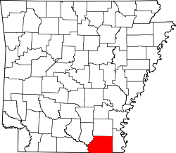
Sulphur Springs, Arkansas
Sulphur Springs's position in Arkansas.
Coordinates: 33°04′18″N92°01′52″W / 33.07167°N 92.03111°W / 33.07167; -92.03111
Country Flag of the United States (23px).png  United States
State Flag of Arkansas.svg  Arkansas
County Ashley
Elevation
[1]
23 m (75 ft)
Time zone UTC-6 (Central (CST))
  Summer (DST) UTC-5 (CDT)
GNIS feature ID78493 [1]

Sulphur Springs (also Sulpher Springs) is an unincorporated community in Ashley County, Arkansas, United States. [1] The community is located at the southern terminus of Arkansas Highway 169. [2]

Related Research Articles

<span class="mw-page-title-main">Miller County, Arkansas</span> County in Arkansas, United States

Miller County is a county located in the southwestern corner of the U.S. state of Arkansas. As of the 2020 census, the population was 42,600. The county seat is Texarkana.

<span class="mw-page-title-main">Ashley County, Arkansas</span> County in Arkansas, United States

Ashley County is a rural South Arkansas county with a culture, economy, and history based on timber and agriculture. Created as Arkansas's 52nd county on November 30, 1848, Ashley County has seven incorporated municipalities, including Hamburg, the county seat and Crossett, the most populous city. The county is also the site of numerous unincorporated communities and ghost towns. The county is named for Chester Ashley, a prominent lawyer in the Arkansas Territory and U.S. senator from the state from 1844 to 1848.

<span class="mw-page-title-main">Sulphur Springs, Benton County, Arkansas</span> City in Arkansas, United States

Sulphur Springs is a city in Benton County, Arkansas, United States. The population was 481 at the 2020 census. It is part of the Northwest Arkansas region.

<span class="mw-page-title-main">Searcy, Arkansas</span> City in Arkansas, United States

Searcy is the largest city and county seat of White County, Arkansas, United States. According to 2019 Census Bureau estimates, the population of the city is 23,767. It is the principal city of the Searcy, AR Micropolitan Statistical Area which encompasses all of White County. The city takes its name from Richard Searcy, a judge for the Superior Court of the Arkansas Territory. A college town, Searcy is the home of Harding University and ASU-Searcy.

<span class="mw-page-title-main">Sulphur Springs, Texas</span> City in Texas, United States

Sulphur Springs is a city in and the county seat of Hopkins County, Texas, United States. As of the 2020 census, its population was 15,941. Sulphur Springs is located along the western edge of Northeast Texas.

<span class="mw-page-title-main">Sulphur River</span> River in Texas and Arkansas in the United States

The Sulphur River is a 175-mile-long (282 km) river in northeast Texas and southwest Arkansas in the United States.

Black Oak is a community in White River Township, Washington County, Arkansas, United States. It is located between Greenland and Elkins and lies six miles southeast of Fayetteville.

Sulphur Springs, also known as White Sulphur Springs, is a census-designated place (CDP) in Spring Township, Jefferson County, Arkansas, United States. Per the 2020 census, the population was 1,032.

Sulphur Springs, Arkansas may refer to one of seven places in Arkansas:

Sulphur Springs is an unincorporated community in Johnson County, Arkansas, United States. Sulphur Springs is located along Arkansas Highway 352, 5.5 miles (8.9 km) west of Clarksville.

Sulphur Springs is an unincorporated community in Montgomery County, Arkansas, United States. Sulphur Springs is 10 miles (16 km) west-northwest of Black Springs.

Sulphur Springs is an unincorporated community in Van Buren County, Arkansas, United States. Sulphur Springs, which was formerly named Morganton, is located near Arkansas Highway 92, 11.5 miles (18.5 km) southeast of Clinton.

Sulphur Springs is an unincorporated community in northern Yell County, Arkansas, United States. The community is located approximately 10 miles (16 km) west-southwest of Dardanelle. The peak of Spring Mountain in southeast Logan County is about 1.5 miles to the north.

<span class="mw-page-title-main">Seminole Hot Springs, California</span> Unincorporated community in California, United States

Seminole Hot Springs is an unincorporated community in Los Angeles County, California, United States. Seminole Hot Springs is located in the Santa Monica Mountains near Cornell, 3.6 miles (5.8 km) south-southeast of Agoura Hills at an elevation of 932 feet (284 m).

<span class="mw-page-title-main">Camp White Sulphur Springs Confederate Cemetery</span> Historic cemetery in Jefferson County, Arkansas

The Camp White Sulphur Springs Confederate Cemetery is an American Civil War cemetery in Arkansas. It is located northeast of the village of Sulphur Springs, also known as White Sulphur Springs, in Jefferson County.

Sulphur City is an unincorporated community in White River Township, Washington County, Arkansas, United States. It is located at the intersection of Black Oak Road and Whitehouse Road (CR 43). The community is on the east bank of the Middle Fork of the White River. The community of Black Oak lies approximately 1.5 miles to the northwest on the opposite side of the river.

<span class="mw-page-title-main">Camp Crowder Gymnasium</span> United States historic place

The Camp Crowder Gymnasium is a historic school building at 205 Shiloh Drive in Sulphur Springs, Benton County, Arkansas. It is primarily a building with local significance, and also is a rare example of military construction in the small community.

<span class="mw-page-title-main">Shiloh House (Sulphur Springs, Arkansas)</span> Historic house in Arkansas, United States

The Shiloh House is a historic house at 700 Lodge Dr. in Sulphur Springs, Benton County, Arkansas. Built in 1927, it is one of the largest examples of Bungalow and Craftsman-style architecture in Benton County.

<span class="mw-page-title-main">Sulphur Springs Cemetery (Sulphur Springs, Arkansas)</span> Historic cemetery in Arkansas, United States

Sulphur Springs Cemetery is a historic cemetery in rural northern Yell County, Arkansas. It is located northwest of Chickalah, on the south side of County Road 39, about 0.2 miles (0.32 km) west of its junction with County Road 38. The cemetery contains 26 marked burial sites on just over 1 acre (0.40 ha) of the 4.5 acres (1.8 ha) property, dating from 1844 to 1940. There are at least two known unmarked burials, and fieldstones in the cemetery may denote further sites. The cemetery is ringed by a barbed wire fence. It is one of the few surviving remnants of the former spa community of Sulphur Springs, which flourished here in the 19th century.

<span class="mw-page-title-main">Arkansas Highway 169</span> State highway in Arkansas, United States

Highway 169 is a designation for three state highways in Southeast Arkansas. One route of 7.82 miles (12.59 km) begins at Sulphur Springs and runs northeast to Hancock Road in Crossett. A second route of 1.27 miles (2.04 km) in McGehee begins at Highway 4 and runs east to US Highway 65/US Highway 165 (US 65/US 165). A third route of 2.21 miles (3.56 km) begins at US 165 and runs east to Arkansas Post. All routes are maintained by the Arkansas Department of Transportation (ArDOT).

References

  1. 1 2 3 U.S. Geological Survey Geographic Names Information System: Sulphur Springs, Ashley County, Arkansas
  2. Arkansas Atlas and Gazetteer (Map) (Second ed.). DeLorme. § 63.