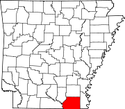
Ashley County is a rural South Arkansas county with a culture, economy, and history based on timber and agriculture. Created as Arkansas's 52nd county on November 30, 1848, Ashley County has seven incorporated municipalities, including Hamburg, the county seat and Crossett, the most populous city. The county is also the site of numerous unincorporated communities and ghost towns. The county is named for Chester Ashley, a prominent lawyer in the Arkansas Territory and U.S. senator from the state from 1844 to 1848.
Scott is an unincorporated community and census-designated place (CDP) in Lonoke and Pulaski counties in the central part of the U.S. state of Arkansas. Per the 2020 census, the population was 97. It is part of the Little Rock–North Little Rock–Conway Metropolitan Statistical Area.

U.S. Route 425 (US 425) is a north–south United States highway that travels in the U.S. states of Mississippi, Louisiana, and Arkansas. It was first commissioned in 1989.

The North American Central Time Zone (CT) is a time zone in parts of Canada, the United States, Mexico, Central America and some Caribbean islands.
Sunshine is sunlight, the electromagnetic radiation emitted by the Sun, especially in the visible wavelengths.
Hamburg High School is a comprehensive public high school for students in grades 9 through 12 located in Hamburg, Arkansas, United States. Since 2004, Hamburg High School is the only high school of the Hamburg School District.

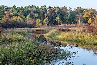
The Arkansas Timberlands is a region of the U.S. state of Arkansas generally encompassing the area south of the Ouachita Mountains, south of Central Arkansas and west of the Arkansas Delta. With several different definitions in use by various state agencies, the Arkansas Timberlands is essentially a region known for dense pine and cypress forests covering hilly terrain and lining numerous rivers. Modern settlement created a significant logging industry and subsequent clearance agriculture which provided the basis of the local economy until the discovery of petroleum. Local tourism is largely based on the popularity of deer hunting and bass fishing. Attractions there include Marks' Mills Battleground Historical Monument, Jenkins' Ferry Battleground Historical Monument, Overflow National Wildlife Refuge, Felsenthal National Wildlife Refuge, South Arkansas Arboretum, Arkansas Museum of Natural Resources, White Oak Lake State Park, Poison Springs Battleground State Park, Millwood State Park, and Pond Creek National Wildlife Refuge. The Arkansas Timberlands is the birthplace of former President of the United States Bill Clinton.
Bayou Bartholomew is the longest bayou in the world, meandering approximately 364 miles (586 km) between the U.S. states of Arkansas and Louisiana.
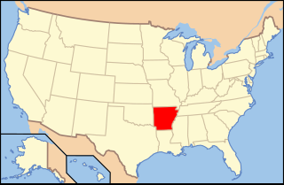
The following is an alphabetical list of articles related to the U.S. State of Arkansas.

Arkansas Highway 133 is a designation for three state highways in South Arkansas. One route of 24.20 miles (38.95 km) runs from Louisiana Highway 142 north through Crossett to Highway 8 near Fountain Hill. A second segment runs from Highway 160 north to US Route 425 (US 425) at Lacey. A third segment begins in Rison at Highway 35 and runs north to Highway 54 south of Pine Bluff.
Sulphur Springs is an unincorporated community in Ashley County, Arkansas, United States. The community is located at the southern terminus of Arkansas Highway 169.
Sunshine is an unincorporated community in Garland County, Arkansas, United States. On April 25, 2011, high winds – possibly a tornado – part of the storm system associated with the 2011 Super Outbreak hit the Sunshine area, destroying houses and trapping and injuring two people.
Sunshine, Arkansas may refer to:
Pearcy is an unincorporated community and census-designated place (CDP) in Garland County, Arkansas, United States. It was first listed as a CDP in the 2020 census with a population of 306.
Crystal Springs is an unincorporated community and census-designated place (CDP) in Garland County, Arkansas, United States. It was first listed as a CDP in the 2020 census with a population of 129.

Highway 52 is a designation for three state highways in Southeast Arkansas. All segments are low volume, two-lane roadways in rural areas. The segment between Wilmot and Indian has been designated since the original 1926 Arkansas state highway numbering, with new designations created in 1966 and 1985. All segments are maintained by the Arkansas Department of Transportation (ArDOT).
Mount Olive is an unincorporated community in Ashley County, Arkansas, United States. Mount Olive is 12 miles (19 km) north-northeast of Hamburg.
Hamburg School District is a public school district headquartered in the S. P. Portis Administration Building in Hamburg, Arkansas, United States. The district is one of three school districts based in Ashley County, Arkansas and operates four schools serving the following rural, fringe communities in Ashley, Drew, and Chicot counties. Communities served by the district include Hamburg, Fountain Hill, Parkdale, Portland, Wilmot, and a section of North Crossett.

Lakeside School District is a public school district based in Lake Village, Arkansas, United States. The Lakeside School District encompasses 242.54 square miles (628.2 km2) of land including all or portions of Chicot County and Ashley County communities. Incorporated places within the district include Lake Village in Chicot County, and Montrose in Ashley County. It also serves the Chicot County unincorporated area of Ross Van Ness.

Arkansas Highway 189 is the designation for a state highway in the U.S. state of Arkansas. The route is split into four sections, all of which are located in southeast Arkansas. The first section is a very short highway that begins at US Highway 425 (US 425) in Hamburg and travels to the Ashley County Fairgrounds just south of Hamburg. The second section begins at US 425, US 82 and AR 8 in Hamburg and ends at AR 133 near the unincorporated community of Milo, or about six miles (9.7 km) southwest of Fountain Hill. The third section begins at US 278 in Warren and ends at US 63 in Warren. The fourth and longest section begins at AR 8 near the unincorporated community of Orlando, or about five miles (8.0 km) northwest of Warren and ends at Pump Station Road in rural Cleveland County.