
Hürth is a town in the Rhein-Erft-Kreis, North Rhine-Westphalia, Germany. Hürth shares borders with the city of Cologne and is about 6 km to the southwest of Cologne city centre, at the northeastern slope of the natural preserve Kottenforst-Ville. The town consists of thirteen districts, once independent villages, and is distributed over a relatively large area. The municipal area is interspersed with lakes and stretches of forest.

Most is a city in the Ústí nad Labem Region of the Czech Republic. It has about 64,000 inhabitants.

Middleton is a largely residential suburb of Leeds in West Yorkshire, England and historically a village in the West Riding of Yorkshire. It is situated on a hill 4 miles (6 km) south of Leeds city centre and 165 miles (266 km) north north-west of London.

Eschweiler is a municipality in the district of Aachen in North Rhine-Westphalia in Germany on the river Inde, near the German-Belgian-Dutch border, and about 15 kilometres (9 mi) east of Aachen and 50 kilometres (31 mi) west of Cologne.
XX World Youth Day was a Catholic youth festival that started on 16 August and continued until 21 August 2005 in Cologne, Germany, commemorating the 20th anniversary of the first World Youth Day held in 1985. It was the first World Youth Day and foreign trip of Pope Benedict XVI, who joined the festival on 18 August. This meeting was decided by the previous pope, John Paul II, during the Toronto World Youth Day of 2002. The theme was "We have come to worship Him".

Frechen is a town in the Rhein-Erft District, North Rhine-Westphalia, Germany. Frechen was first mentioned in 877. It is situated at the western Cologne city border.

Bergheim is a German town, 22 km west of Cologne and the capital of the Rhein-Erft-Kreis (district). The town's Niederaußem district is one of the most important suppliers for energy from lignites in Europe.

Borna is a town in Saxony, Germany, capital of the Leipzig district. It is situated approximately 30 km southeast of Leipzig city. It has approx. 19,000 inhabitants. The town is the district seat of the district of Leipzig.
The pilgrimage from Osnabrück to Telgte takes place since 1852 on the second Sunday after the Feast of Saints Peter and Paul; it is known as Telgte pilgrimage or Osnabrück pilgrimage. Each year approximately 8,000 pilgrims participate in the 47 km long walk along the B51 and more visitors arrive by bus or car.
The Geisel valley is a valley in Saxony-Anhalt, Germany, situated west of Merseburg, Saalekreis district. It is named after the River Geisel which rises in Mücheln and is a tributary of the Saale, just under 25 km (16 mi) long.
The Tagebau Hambach is a large open-pit coal mine in Niederzier and Elsdorf, North Rhine–Westphalia, Germany. It is operated by RWE and used for mining lignite.

Hora Svaté Kateřiny is a town in Most District in the Ústí nad Labem Region of the Czech Republic. It has about 500 inhabitants.

The Tagebau Garzweiler is a surface mine in the German state of North Rhine-Westphalia. It is operated by RWE and used for mining lignite. The mine currently has a size of 48 km2 (19 sq mi) and got its name from the village of Garzweiler which previously existed at this location. The community was moved to a section of Jüchen with the same name.

The Turów coal mine or KWB Turów, is a large open pit mine in the southwest of Poland, located outside Bogatynia, Lower Silesia. It feeds the nearby Turów Power Station. The mine is scheduled to be shut down by 2044 when its coal reserves are expected to be depleted.
Bottenbroich Abbey, later Bottenbroich Priory, was a former Cistercian religious house located in Bottenbroich, now in Frechen, about three kilometres north-east of Kerpen, in the present Rhein-Erft-Kreis of North Rhine-Westphalia, Germany.

Horrem station is a station in the Kerpen district of Horrem in the German state of North Rhine-Westphalia. It is a railway junction of the Cologne–Aachen high-speed railway and the Erft Railway. The triangular station of Horrem is served by regional services and by S-Bahn trains of the Rhine-Ruhr S-Bahn. Long-distance trains run through on the high-speed line without stopping. It is classified by Deutsche Bahn as a category 3 station.

Geiseltalsee, literally Geisel valley lake, is at about 1,840 hectares the largest artificial lake by area in Germany. Once flooding of the Cottbuser Ostsee is complete it will surpass Geiseltalsee in surface area, covering 19 square kilometres (7.3 sq mi). Geiseltalsee lies in the Saalekreis district of the state Saxony-Anhalt. The lake was created in 2003-11 by flooding a former opencast lignite mine in the Geiseltal ; the name of that valley had become widely known due to the notable fossil record which emerged from that coal mine.

The Church of St. Lambertus, known locally as the Immerather Dom, was a Roman Catholic parish church in the village of Immerath, Erkelenz in North Rhine-Westphalia, Germany. A church dedicated to Saint Lambert of Maastricht had existed on the site since at least the 12th century, being rebuilt and enlarged a number of times before being demolished in 1888. It was replaced by Romanesque Revival church building, which was constructed between 1888 and 1891 to designs of Erasmus Schüller.

Anton Josef Reiss, also Reiß was a German sculptor. Based in Düsseldorf, he focused on sacred art for churches, including a marble Pietà for St. Gereon in Cologne in a style close to the Nazarene movement.

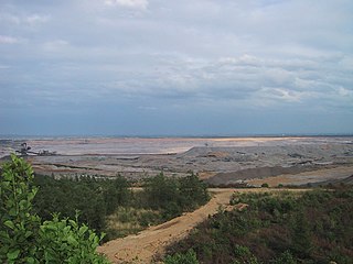
The Rheinisches Braunkohlerevier, often called the Rhenish mining area, is a lignite mining area or district in the Cologne Bay, on the northwestern edge of the Rhenish Slate Mountains. The mining of lignite using the open pit method has had a significant impact on the landscape here and led to the formation of several important industrial sites. The area includes the Zülpicher and Jülicher Börde, the Erft lowlands and the Ville, making it the largest lignite mining area in Europe. To a lesser extent clay, silica sand and loess are mined here. The area is the only active lignite mining area in what was West Germany during German partition and contains the mines with the largest surface area, greatest depth, and biggest annual output of coal.

