
Algonquin is a village in McHenry and Kane counties, Illinois, in the United States. It is a suburb of Chicago, located approximately 40 miles (64 km) northwest of the Loop. As of the 2020 census, the village's population was 29,700.

Mundelein is a village in Lake County, Illinois, United States and a northern suburb of Chicago. Per the 2020 census, the population was 31,560. It is approximately thirty-five miles northwest of Chicago.
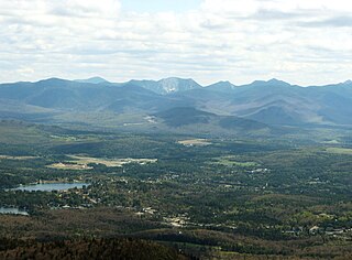
Lake Placid is a village in the Adirondack Mountains in Essex County, New York, United States. In 2020, its population was 2,205.

Saranac Lake is a village in the state of New York, United States. As of the 2020 census, the population was 4,887, making it the largest community by population in the Adirondack Park. The village is named after Upper, Middle and Lower Saranac lakes, which are nearby.

Hornindalsvatnet is Norway's and Europe's deepest lake, and the world's thirteenth deepest lake, officially measured to a depth of 514 m (1,686 ft). Its surface is 53 m (174 ft) above sea level, which means that its bottom is 461 m (1,512 ft) below sea level.

Ashtamudi Lake, in the Kollam District of the Indian state of Kerala. It possesses a unique wetland ecosystem and a large palm-shaped water body, second only in size to the Vembanad estuary ecosystem of the state. Ashtamudi means 'eight braids' in the local Malayalam language. The name is indicative of the lake's topography with its multiple branches. The lake is also called the gateway to the backwaters of Kerala and is well known for its houseboat and backwater resorts. Ashtamudi Wetland was included in the list of wetlands of international importance, as defined by the Ramsar Convention for the conservation and sustainable utilization of wetlands.
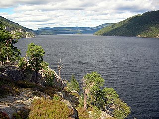
Tinnsjå is one of the largest lakes in Norway measuring about 51.38 km2 (19.84 sq mi). It is also one of the deepest lakes in Europe, reaching a depth of 460 m (1,510 ft). Tinnsjå is located in the municipalities of Tinn and Notodden in Vestfold og Telemark county. At its source in the west, the Måna river flows out of the lake Møsvatn and past the town of Rjukan into Tinnsjå. From the north, the river Mår flows from the lakes Mår, Gøystavatn, and Kalhovdfjorden into Tinnsjå. Tinnsjå is part of the Skien watershed, and it drains via the Tinnelva river in the south, down to the lake Heddalsvatn.
Våvatnet is a lake in Orkland Municipality in Trøndelag county, Norway. The lake was dammed in 1910 and is used as the main reservoir for the municipality of Orkdal. The water flows into the lake Songsjøen and then into the lake Gagnåsvatnet.
Åraksfjorden is a lake in the municipality of Bygland in Agder county, Norway. The 11.96-square-kilometre (4.62 sq mi) lake is part of the Otra drainage basin. The northern part of the lake is fed directly by the river Otra. The southern part of the lake goes through a narrow channel which leads into the Byglandsfjorden. The villages of Frøysnes and Skåmedal are located along the western side of the lake and on the eastern side are the villages of Sandnes and Åraksbø. The Norwegian National Road 9 runs along the eastern side of the lake.
Kilefjorden is a lake on in Agder county, Norway. The lake is located on the border of the municipalities of Evje og Hornnes, Iveland, and Vennesla. The lake is part of the river Otra. The lake is located about 6 kilometres (3.7 mi) west of the village of Birketveit in Iveland, about 2.5 kilometres (1.6 mi) north of the village of Hægeland in Vennesla, and about 15 kilometres (9.3 mi) south of the village of Hornnes in Evje og Hornnes.

Herefossfjorden is a lake in the municipality of Birkenes in Agder county, Norway. The 3.7-square-kilometre (1.4 sq mi) lake is about 9 kilometres (5.6 mi) long and it is part of the Tovdalselva river. The Gauslåfjorden and Uldalsåna lakes flow into Herefossfjorden near the village of Herefoss at the northern end of the lake. The Uldalsåna lake is held back by a dam and the Gauslåfjorden flows over a waterfall into the Herefossfjorden. The Norwegian National Road 41 runs along the eastern shore. The village of Herefoss lies on the northern edge of the lake and the village of Søre Herefoss lies at the southern end of the fjord. The old municipality of Herefoss existed from 1838 until 1967 and it included all the land surrounding the lake.
Gilten is a lake in the municipality of Steinkjer in Trøndelag county, Norway. The 31.62-square-kilometre (12.21 sq mi) lake lies in the northern part of Steinkjer, about 8 kilometres (5.0 mi) northeast of the village of Kvam, about 1.5 kilometres (0.93 mi) north of the village of Følling, and about 14 kilometres (8.7 mi) east of the village of Namdalseid. The lake is only accessible by road from Namdalseid, even though most of the 31.62-square-kilometre (12.21 sq mi) lake lies in Steinkjer. The lake Bangsjøan lies to the northeast and the lake Snåsavatnet lies to the south.
Straumsetervatnet or Selavatnet is a lake on the border of the municipalities of Åfjord and Steinkjer in Trøndelag county, Norway. The majority of the 4.72-square-kilometre (1.82 sq mi) lake lies in Steinkjer, with the northwestern end of the lake partially lying in Åfjord. The village of Sela lies on the northern side of the lake and the village of Sandsetra at the southeastern end of the lake. The lake is one of the sources for the Folla river system which flows into the Trondheimsfjord at the village of Follafoss.

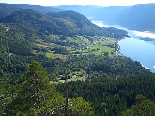
Oppstrynsvatn is a lake in the municipality of Stryn in Vestland county, Norway. It is located about 8 kilometres (5.0 mi) east of the village of Stryn. The villages of Flo, Oppstryn, and Erdal are located on the shores of the lake.

A fishing village is a village, usually located near a fishing ground, with an economy based on catching fish and harvesting seafood. The continents and islands around the world have coastlines totalling around 356,000 kilometres (221,000 mi). From Neolithic times, these coastlines, as well as the shorelines of inland lakes and the banks of rivers, have been punctuated with fishing villages. Most surviving fishing villages are traditional.

Uphusen is a village in Lower Saxony, Germany. The East Frisian village is currently a borough of the city of Emden together with Marienwehr.


