Lower Saxony is a German state in northwestern Germany. It is the second-largest state by land area, with 47,614 km2 (18,384 sq mi), and fourth-largest in population among the 16 Länder of the Federal Republic of Germany. In rural areas, Northern Low Saxon and Saterland Frisian are still spoken, though by declining numbers of people.

Frisia is a cross-border cultural region in Northwestern Europe. Stretching along the Wadden Sea, it encompasses the north of the Netherlands and parts of northwestern Germany. Wider definitions of "Frisia" may include the island of Rem and the other Danish Wadden Sea Islands. The region is traditionally inhabited by the Frisians, a West Germanic ethnic group.
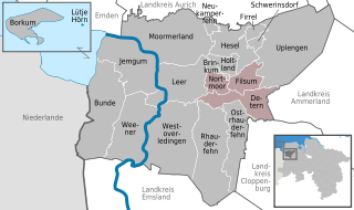
Leer is a district (Landkreis) in Lower Saxony, Germany. It is bounded by the city of Emden, the districts of Aurich, Wittmund, Friesland, Ammerland, Cloppenburg and Emsland, and by the Netherlands.

East Frisia or East Friesland is a historic region in the northwest of Lower Saxony, Germany. It is primarily located on the western half of the East Frisian peninsula, to the east of West Frisia and to the west of Landkreis Friesland.
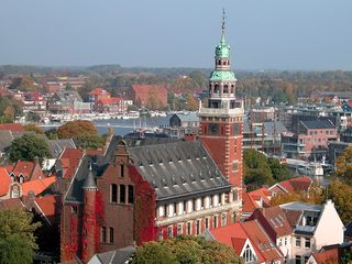
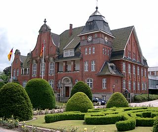
Leer is a town in the district of Leer, in the northwestern part of Lower Saxony, Germany. It is situated on the river Leda, a tributary of the river Ems, near the border with the Netherlands. With 34,958 inhabitants (2021), it is the third-largest city in East Frisia after Emden and Aurich.

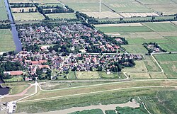
Greetsiel is a small port on the bight of Leybucht in western East Frisia, Germany, that was first documented in letters from the year 1388. Since 1972, Greetsiel has been part of the municipality of Krummhörn, which has its administrative seat in Pewsum. The nearest railway station is at Emden, about 15–20 kilometres (9.3–12.4 mi) away, and the two towns are linked by a bus service.

Dagebüll is a municipality located at the west coast of Schleswig-Holstein in the Nordfriesland district, Germany. Today's Dagebüll was created in 1978 as a merger of the municipalities of Fahretoft, Juliane-Marien-Koog and Waygaard. Dagebüll used to be a Hallig, the oldest houses were built on artificial dwelling hills which in parts can still be seen today. In 1704 the area was secured by sea dikes.
Jümme is a collective municipality (Samtgemeinde) in the district of Leer in the German state of Lower Saxony. It is named after the River Jümme which flows through all three constituent communities. It has an area of 82.34 km2 and a population of 6,421. It is situated in the region of East Frisia. Along with the Samtgemeinde of Hesel, it is one of two in the district. It was formed in the wake of local government reform in 1973. Filsum serves as the administrative centre.
Papenburg is a city in the district of Emsland, Lower Saxony, Germany, situated at the river Ems. It is known for its large shipyard, the Meyer-Werft, which specializes in building cruise liners.
The Ripperda family is an old and prominent family that belonged to the German, Austrian, Spanish and Dutch nobility. Members of this family have played a major role in European history as soldiers, politicians and diplomats.

The formerly independent village of Wiegboldsbur in East Frisia in North Germany has been part of the municipality of Südbrookmerland since the regional reform of 1972. Wiegboldsbur is a ribbon development (Reihensiedlung) and lies on the Großes Meer about 10 km northwest of the seaport of Emden. The parish chair is Bernhard Behrends (SPD).

Pewsum is a village in the municipality of Krummhörn in the west of East Frisia, in Lower Saxony, Germany. Pewsum is both the administrative seat as well as the trade and craft centre of the municipality. The number of inhabitants was 3,352 in 2006 and the village lies at a height of 0 m above sea level (NN).
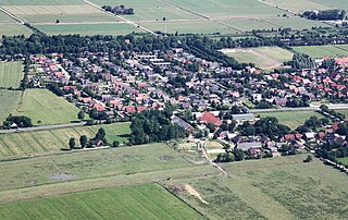
Groothusen is an old Langwurtendorf – a village on an artificially-built ridge – in the municipality of Krummhörn in western East Frisia on Germany's North Sea coast. It lies about 15 kilometres northwest of the seaport of Emden and has a population of 474 (2006). The ridge or warf has a length of about 500 metres and a width of some 130 metres and was built to raise the village above the water level should flooding from the sea occur, for instance, during a storm tide.
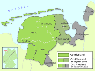
East Frisia is a collective term for all traditionally Frisian areas in Lower Saxony, Germany, which are primarily located on a peninsula between the Dollart and the Jade Bight. Along with West Frisia and North Frisia, it is one of the most commonly used subdivisions of Frisia.
Morsum is a village on the North Sea island of Sylt in the district of Nordfriesland in Schleswig-Holstein, Germany. Today, it is an Ortsteil of the Gemeinde Sylt. Morsum is located close to the scientifically important geotope Morsum-Kliff and to the beginning of the Hindenburgdamm linking Sylt with the mainland.

Bedekaspel is an East Frisian village in Lower Saxony, Germany. It is an Ortsteil of the municipality of Südbrookmerland. It is located near the Großes Meer. A Haufendorf, the village of Bedekaspel includes Wochenendsiedlung, a recreational area on the northern shore of the Großes Meer, and Bedekaspeler Marsch.
Widdelswehr is a village in Lower Saxony, Germany. Together with Jarßum, it is a district of the city of Emden. It is located on the northern embankment of the Ems and to the west of Petkum. Until 1972, Widdelswehr was an independent municipality that was part of the district Leer.

Borssum or Borßum is a village in Lower Saxony, Germany. Together with the village of Hilmarsum it forms a district of Emden. The East Frisian village on the Eems is located southeast of the city.

Larrelt is a former village in Lower Saxony, Germany. The centuries-old East Frisian village originally belonged to the former Landkreis Norden, but was added to the city of Emden as a district immediately after the Second World War. It currently lies directly to the north of the Emden industrial estate.
Visquard is a village in the region of East Frisia, in Lower Saxony, Germany. It is part of the municipality of Krummhörn. The village is located to the north of Pewsum and to the south of Greetsiel.