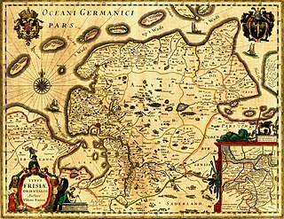
Frisia is a cross-border cultural region in Northwestern Europe. Stretching along the Wadden Sea, it encompasses the north of the Netherlands and parts of northwestern Germany. The region is traditionally inhabited by the Frisians, a West Germanic ethnic group.

East Frisia or East Friesland is a historic region in the northwest of Lower Saxony, Germany. It is primarily located on the western half of the East Frisian peninsula, to the east of West Frisia and to the west of Landkreis Friesland.

The title Earl of Dunbar, also called Earl of Lothian or Earl of March, applied to the head of a comital lordship in south-eastern Scotland between the early 12th century and the early 15th century. The first man to use the title of Earl in this capacity was Gospatric II, Earl of Lothian, son of Gospatric, Earl of Northumbria. It descended to George de Dunbar, 11th Earl of March, whose titles & estates were declared forfeit by parliament in 1435, and retired into obscurity in England. His son Patrick retained a barony at Kilconquhar in Fife.
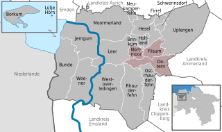
Jümme is a collective municipality (Samtgemeinde) in the district of Leer in the German state of Lower Saxony. It is named after the River Jümme which flows through all three constituent communities. It has an area of 82.34 km² and a population of 6,421. It is situated in the region of East Frisia. Along with the Samtgemeinde of Hesel, it is one of two in the district. It was formed in the wake of local government reform in 1973. Filsum serves as the administrative centre.

The Evenburg is a water castle in the village of Loga (Leer) in north Germany not far from the River Leda.

Baltrum is a barrier island off the coast of East Frisia, in Germany, and is a municipality in the district of Aurich, Lower Saxony. It is located in-between the chain of the seven inhabited East Frisian Islands. Baltrum is the smallest island in this chain by area and inhabitants. It has a land area of 6.5 square kilometres, and a population in (2011) of just over 500 resident inhabitants.

Dornum is a village and a municipality in the East Frisian district of Aurich, in Lower Saxony, Germany. It is situated near the North Sea coast, approx. 15 km east of Norden, and 20 km north of Aurich.
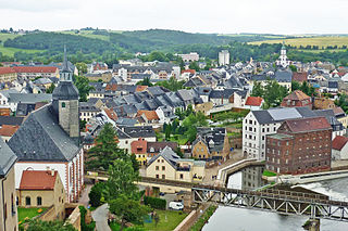
Rochlitz is a major district town in the district of Mittelsachsen, in Saxony, Germany. Rochlitz is the head of the "municipal partnership Rochlitz" with its other members being the municipalities of Königsfeld, Seelitz and Zettlitz.
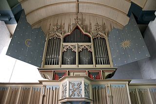
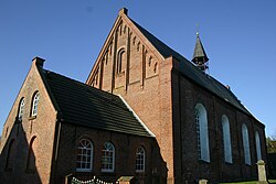
The Rysum organ in Rysum Church in Rysum, north Germany, is the oldest instrument of its kind in northern Europe that still largely has its original pipes. It is also one of the oldest playable church organs in the world alongside those in Sion, St. Valentin in Kiedrich, and Ostönnen. The exact date of its construction is not entirely known, but dates of 1457 and 1440 have been proposed. It was rebuilt in 1513. After undergoing several other modifications through the years it was restored to its 1513 condition by Jürgen Ahrend and Gerhard Brunzema in 1959. The organ has seven stops on one manual.
Frisia has changed dramatically over time, both through floods and through a change in identity. It is part of the Nordwestblock which is a hypothetical historic region linked by language and culture,where they may have spoken an Indo-European language which was neither germanic nor celtic.

Anna of Oldenburg was a Countess consort of East Frisia as the spouse of Count Enno II of East Frisia. She was the Regent of East Frisia in 1542–1561 as the guardian for her minor sons, Johan II and Edzard II. Her reign lasted until 1561 and was generally supported by the Estates.
The history of East Frisia developed rather independently from the rest of Germany because the region was relatively isolated for centuries by large stretches of bog to the south, while at the same time its people were oriented towards the sea. Thus in East Frisia in the Middle Ages there was little feudalism, instead a system of fellowship under the so-called Friesian Freedom emerged. It was not until 1464, that the House of Cirksena was enfeoffed with the Imperial County of East Frisia. Nevertheless absolutism had been, and continued to be, unknown in East Frisia. In the two centuries after about 1500, the influence of the Netherlands is discernable - politically, economically and culturally. In 1744, the county lost its independence within the Holy Roman Empire and became part of Prussia. Following the Vienna Congress of 1815, it was transferred to the Kingdom of Hanover, in 1866 it went back to Prussia and, from 1946, it has been part of the German state of Lower Saxony.
Groothusen is an old Langwurtendorf – a village on an artificially-built ridge – in the municipality of Krummhörn in western East Frisia on Germany's North Sea coast. It lies about 15 kilometres northwest of the seaport of Emden and has a population of 474 (2006). The ridge or warf has a length of about 500 metres and a width of some 130 metres and was built to raise the village above the water level should flooding from the sea occur, for instance, during a storm tide.
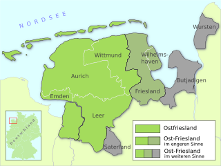
East Frisia is a collective term for all traditionally Frisian areas in Lower Saxony, Germany, which are primarily located on a peninsula between the Dollart and the Jade Bight. Along with West Frisia and North Frisia, it is one of the most commonly used subdivisions of Frisia.
Uko Fockena was an East Frisian chieftain of Moormerland and Emsigerland.
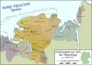
The East Frisian chieftains assumed positions of power in East Frisia during the course of the 14th century, after the force of the old, egalitarian constitution from the time of Frisian Freedom had markedly waned.

The Bay of Sielmönken or Bight of Sielmönken is a former bay on the territory of the present day municipality of Krummhörn in the west of East Frisia in Germany. The bight reached its greatest extent during the Carolingian transgression of 800 to 950 A. D. After that it silted up heavily and was completely enclosed by dykes between 1,000 A. D. and the 13th century.

Petkum is the easternmost district of the German city of Emden, in Lower Saxony. It is located to the east of Widdelswehr. Until 1972 it was part of the Leer district, since then it has been administratively part of the city of Emden.
Widdelswehr is a village in Lower Saxony, Germany. Together with Jarßum, it is a district of the city of Emden. It is located on the northern embankment of the Ems and to the west of Petkum. Until 1972, Widdelswehr was an independent municipality that was part of the district Leer.

Wybelsum is a village in Lower Saxony, Germany. Located to the west of the city, it is administratively a district of Emden. The village was incorporated as such on 1 July 1972, as were the villages of Logumer Vorwerk and Twixlum.