Marinier Archipelago

Last updated

Marinier Archipelago
Native name:
Archipel Marinier
Archipel Marinier du lac Magog.jpg
Aerial view of the Marinier Archipelago in the southern end of Lake Magog
Canada Quebec location map 2.svg
Red pog.svg
Marinier Archipelago
Geography
Location Lake Magog
Coordinates 45°16′20″N72°03′11″W / 45.27222°N 72.05306°W / 45.27222; -72.05306 Coordinates: 45°16′20″N72°03′11″W / 45.27222°N 72.05306°W / 45.27222; -72.05306
ArchipelagoMarinier
Total islands3
Area0.0115 km2 (0.0044 sq mi)
Administration
Canada
Province Quebec
Regional county municipality Memphremagog
Municipality Sainte-Catherine-de-Hatley

The Marinier Archipelago groups the Odanak Islands, three islands located in the southern end of Lake Magog in the Estrie region of Quebec, Canada. It is part of Sainte-Catherine-de-Hatley.

History

The larger island of the archipelago was originally 6 acres (2.4 hectares ), covered with grass, and used as pasture for a few cows brought to the island on a raft at spring time by the owner Ambroise Gaudreau. In fall, the farmer swan them back to the bank. When the Rock Forest hydroelectric dams was built in 1911, [1] the water level of Lake Magog rose by about 3 feet (0.91 metres ), which flooded many fields while increasing the size of the lake. The island then reduced size from about 6 acres (2.4 hectares) to 6 acres (2.4 hectares). In 1923, the island became the property of two priests, Charles-Edmond Chartier and Joseph Têtu, who are joined a few weeks later by Canon Émile Chartier, then First Vice-Rector and General Chaplain of the Université de Montréal. Chartier then bought back the part of Father Têtu in 1925, then that of Father Chartier in 1934. In 1938, Canon Chartier built a wooden house with a tower on top of the highest rocky summit of the island, with three footbridges and a two-storey boathouse. He named this house Odanak (which means "at home" in the Abenaki language), and had many trees planted all over the island, especially numerous white pines. In 1956, the island (then named Island Chartier [2] [3] [4] ) was acquired by the Orphanage Saint-Joseph of Waterville, in 1967, by the brothers of Holy Cross of Montreal, and then in 1974, by Jacques Darche of Sainte-Catherine-de-Hatley who donated it to the religious community Marie-Jeunesse in 1997. During the winter of 2003, the house on the island was heavily plundered and vandalised.

The smaller island of the archipelago and the islet next to it were originally formed a single island, with a small house perched on top of the rocky hill. When Lake Magog was flooded in 1911, the island was split in two. Only the concrete base of the house's chimney remains today on the small island. In 1959, the island was acquired from Rose-Anna Bernier-Lagasse by the accountant Lionel Jacques, in 1962, by the salesman Léonard Chartier (without kinship with the priest nor the canon Chartier), in 1968, by the radio writer André Boulanger, in 1971, by the engineer Jacques Lemieux, and then in 1976, by the merchant Jacques Darche.

In 2005 and 2006, the islands of the archipelago were acquired from different owners by Bruno-Marie Béchard Marinier, [5] then Rector of the Université de Sherbrooke. The new owner upgraded the housing on the larger island, while maintaining its natural setup. The smaller island is accessible to the public, and is a popular stop while kayaking on Lake Magog.

Related Research Articles

<span class="mw-page-title-main">Sherbrooke</span> City in Quebec, Canada

Sherbrooke is a city in southern Quebec, Canada. It is at the confluence of the Saint-François and Magog rivers in the heart of the Estrie administrative region. Sherbrooke is also the name of a territory equivalent to a regional county municipality (TE) and census division (CD) of Quebec, coextensive with the city of Sherbrooke. With 172,950 residents at the Canada 2021 Census, it is the sixth largest city in the province and the 30th largest in Canada. The Sherbrooke Census Metropolitan Area had 227,398 inhabitants, making it the fourth largest metropolitan area in Quebec and 19th in Canada.

<span class="mw-page-title-main">Terrebonne, Quebec</span> City in Quebec, Canada

Terrebonne is an off-island suburb of Montreal, in southwestern Quebec, Canada. It is located in the North Shore region of the Montreal area, north of Laval across the Rivière des Mille-Îles.

<span class="mw-page-title-main">West Island</span> Settlements in Quebec, Canada

The West Island is the unofficial name given to the cities, towns and boroughs at the western end of the Island of Montreal, in Quebec, Canada. It is generally considered to consist of the Lakeshore municipalities of Dorval, Pointe-Claire, and Beaconsfield, the municipalities of Kirkland, Dollard-des-Ormeaux, Baie-D'Urfé, Sainte-Anne-de-Bellevue, the village of Senneville, and two North Shore boroughs of the city of Montreal: Pierrefonds-Roxboro and L'Île-Bizard–Sainte-Geneviève.

<span class="mw-page-title-main">Île Bizard</span>

Île Bizard is an island near the Island of Montreal in the Hochelaga Archipelago region.

Sainte-Marie or Ste. Marie may refer to the several places:

Area codes 819 and 873 are telephone area codes in the North American Numbering Plan (NANP) for central and western Quebec, Canada, including the Quebec portion of the National Capital Region, and the Hudson Strait and Ungava Bay coastlines of Quebec. Major cities in the territory include Gatineau, Sherbrooke, Trois-Rivières, Drummondville, Shawinigan, Victoriaville, Rouyn-Noranda, Val-d'Or, Magog and Mont-Laurier.

<span class="mw-page-title-main">Brome—Missisquoi</span> Federal electoral district in Quebec, Canada

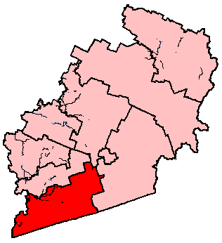
Brome—Missisquoi is a federal electoral district in Quebec, Canada, that has been represented in the House of Commons of Canada since 1925. The original electoral district of Missiquoi existed from 1867 to 1925.

The 2000–2006 municipal reorganization in Quebec resulted in large-scale amalgamation of smaller municipalities in Quebec into larger cities. It was undertaken by one administration, and modified and partially undone by its successor.

Compton was a federal electoral district in Quebec, Canada, that was represented in the House of Commons of Canada from 1867 to 1949, and again from 1968 to 1997.

<span class="mw-page-title-main">Saint-Pierre, Saint Pierre and Miquelon</span> Capital of Saint Pierre and Miquelon

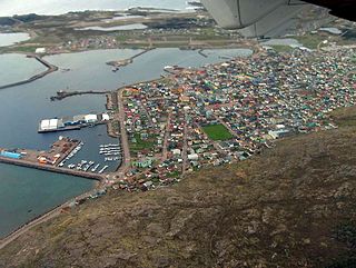
Saint-Pierre is the capital of the French overseas collectivity of Saint Pierre and Miquelon, off the coast of the Canadian island of Newfoundland. Saint-Pierre is the more populous of the two communes (municipalities) making up Saint Pierre and Miquelon.

<span class="mw-page-title-main">Sainte-Geneviève, Quebec</span> Neighbourhood in Montreal, Quebec, Canada

Sainte-Geneviève was a municipality located on the Island of Montreal in southwestern Quebec, Canada. It is now part of the Borough of L'Île-Bizard–Sainte-Geneviève in the City of Montreal, created on January 1, 2002.

<span class="mw-page-title-main">Downtown Montreal</span> Neighbourhood, central business district of Montreal in Quebec, Canada

Downtown Montreal is the central business district of Montreal, Quebec, Canada.

<span class="mw-page-title-main">Sainte-Catherine-de-Hatley</span> Municipality in Quebec, Canada

Sainte-Catherine-de-Hatley is a municipality in the Memphrémagog Regional County Municipality in the Eastern Townships region of Quebec, Canada.

<span class="mw-page-title-main">Abbey of Saint Genevieve</span> Monastery in Paris suppressed at the time of the French Revolution

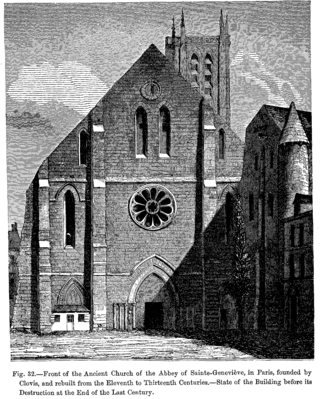
The Abbey of Saint Genevieve was a monastery in Paris. Reportedly built by Clovis, King of the Franks in 502, it became a centre of religious scholarship in the Middle Ages. It was suppressed at the time of the French Revolution.

<span class="mw-page-title-main">Charron Island</span>

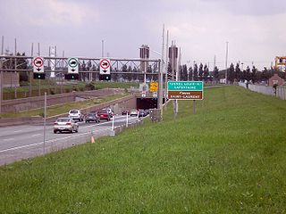
Charron Island is an island in the Saint Lawrence River, the westernmost of the Îles de Boucherville archipelago, near Îles-de-Boucherville National Park to the northeast of Montreal. It is part of the city of Longueuil, and is connected to the mainland and the Island of Montreal by the Louis-Hippolyte Lafontaine Bridge–Tunnel which carries Quebec Autoroute 25 and the Trans-Canada Highway.

<span class="mw-page-title-main">Lake Magog</span> Body of water

Lake Magog is a freshwater lake located in the Estrie region of Quebec, Canada. It is bordered by three municipalities: Sherbrooke, Magog and Sainte-Catherine-de-Hatley. Located in the Appalachian geological province, Lake Magog consists of sedimentary rock, especially slate and sandstone. Lake Magog is part of the watershed of the St. Francois River, which flows into the St. Lawrence River.

<span class="mw-page-title-main">Archipelago of Saint-Pierre Lake</span>

The Archipelago of Lake Saint Pierre counts 103 islands in the western part of Lake Saint Pierre, in Quebec, in Canada. There are two groups: Islands of Berthier to the north and the islands of Sorel to the south.

The Piggery Theatre is a summer community theater in Sainte-Catherine-de-Hatley, in the Memphrémagog Regional County Municipality, in Estrie, in Quebec, Canada. By 1990, the Piggery was already the oldest professional English-language theater in Quebec and the only English-language summer theater in the province.

References

  1. Centrale Rock Forest - Ville de Sherbrooke Archived 2015-08-18 at archive.today
  2. 1962-01-22 - Crépeau, Crépeau, Melanson & Bédard, avocats - Vente pour taxes de l'Ile Chartier
  3. 1962-02-06 - Municipalité de Ste-Catherine-de-Hatley - L'ile Mgr Chartier
  4. 1970-06-15 - Eugène Thérien inc., évaluateurs - Propriété des frères de Ste-Croix, Ile Chartier, Ste-Catherine d'Hatley, P.Que.
  5. 2005-09-17 - La Tribune - Le recteur Béchard a trouvé ses îles