Martini Creek is a coastal stream whose watershed lies entirely within San Mateo County, California, United States on the western exposures of the Montara mountain block, discharging to the Pacific Ocean. It flows about 2 miles (3 km) from its source on Montara Mountain to its mouth in Montara State Beach. This stream has a drainage basin composed of open space and agricultural lands. Some of the basin has moderate to steep slopes and much of the basin habitat is northern coastal scrub, and in places almost of a pygmy forest nature.

San Mateo County, officially the County of San Mateo, is a county located in the U.S. state of California. As of the 2010 census, the population was 718,451. The county seat is Redwood City.

Montara Mountain, positioned between the unincorporated community of Montara, California to the southwest and the city of Pacifica, California to the north, forms the northern spur of the Santa Cruz Mountains, a narrow mountain range running the length of the San Francisco Peninsula that separates San Francisco Bay from the Pacific Ocean. Its highest point rises to 1,898 feet (579 m) above sea level. An unpaved fire road, the North Peak Access Road, accessible from the Pedro Mountain Road in McNee Ranch State Park, provides access to the summit by hikers from the south. From the north, Montara Mountain Trail, Hazelnut Trail and Brooks Creek Trail provide access to the mountain with trailheads in San Pedro Valley County Park.

Montara State Beach is a beach located eight miles north of Half Moon Bay on State Route 1 in California, USA. It is operated by the California State Department of Parks and Recreation under the San Mateo Coast Sector Office. It is one of the cleanest beaches in the state and is known for surfing and fishing.
There are numerous species of flora and fauna which are found in this watershed, including the rare plant Hickman's potentilla. Yellow Bush Lupine is also seen here in a low growing form

Flora is the plant life occurring in a particular region or time, generally the naturally occurring or indigenous—native plant life. The corresponding term for animal life is fauna. Flora, fauna and other forms of life such as fungi are collectively referred to as biota. Sometimes bacteria and fungi are also referred to as flora, as in the terms gut flora or skin flora.

Fauna is all of the animal life present in a particular region or time. The corresponding term for plants is flora. Flora, fauna and other forms of life such as fungi are collectively referred to as biota. Zoologists and paleontologists use fauna to refer to a typical collection of animals found in a specific time or place, e.g. the "Sonoran Desert fauna" or the "Burgess Shale fauna". Paleontologists sometimes refer to a sequence of faunal stages, which is a series of rocks all containing similar fossils. The study of animals of a particular region is called faunistics.
The creek name became widely publicized when a highway alternative for the Devil's Slide bypass became dubbed the "Martini Creek Alignment". The highway proposal caused considerable study during the 1980s and 1990s of biology, geology, air quality and acoustics conditions within this watershed.

Devil's Slide is a coastal promontory in California, United States. It lies on the San Mateo County coast between Pacifica and Montara.
Biology is the natural science that studies life and living organisms, including their physical structure, chemical processes, molecular interactions, physiological mechanisms, development and evolution. Despite the complexity of the science, there are certain unifying concepts that consolidate it into a single, coherent field. Biology recognizes the cell as the basic unit of life, genes as the basic unit of heredity, and evolution as the engine that propels the creation and extinction of species. Living organisms are open systems that survive by transforming energy and decreasing their local entropy to maintain a stable and vital condition defined as homeostasis.
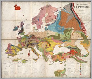
Geology is an earth science concerned with the solid Earth, the rocks of which it is composed, and the processes by which they change over time. Geology can also include the study of the solid features of any terrestrial planet or natural satellite such as Mars or the Moon. Modern geology significantly overlaps all other earth sciences, including hydrology and the atmospheric sciences, and so is treated as one major aspect of integrated earth system science and planetary science.

California State Route 1 (SR 1) is a major north–south state highway that runs along most of the Pacific coastline of the U.S. state of California. At a total of just over 659 miles (1,061 km), it is the longest state route in California. SR 1 has several portions designated as either Pacific Coast Highway (PCH), Cabrillo Highway, Shoreline Highway, or Coast Highway. Its southern terminus is at Interstate 5 (I-5) near Dana Point in Orange County and its northern terminus is at U.S. Route 101 (US 101) near Leggett in Mendocino County. SR 1 also at times runs concurrently with US 101, most notably through a 54-mile (87 km) stretch in Ventura and Santa Barbara counties, and across the Golden Gate Bridge.

Montara is a census-designated place (CDP) in San Mateo County, California, United States. The population was 2,909 at the 2010 census. Nearby communities include Moss Beach and Princeton-by-the-Sea.
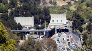
The Caldecott Tunnel is an east-west highway tunnel through the Berkeley Hills between Oakland and Orinda, California. Its four bores carry California State Route 24. Named after Thomas E. Caldecott, former mayor of Berkeley, it opened in 1937 as a two-bore tunnel. The third bore opened in 1964 and the fourth bore in 2013. Currently, the two oldest bores carry eastbound traffic and the two newest bores carry westbound traffic.
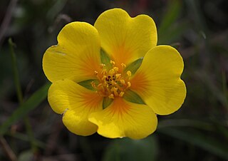
Potentilla hickmanii is an endangered perennial herb of the rose family. This rare plant species is found in a narrowly restricted range in two locations in coastal northern California, in Monterey County, and in very small colonies in San Mateo County. This small wildflower, endemic to western slopes of the outer coastal range along the Pacific Ocean coast, produces bright yellow blossoms through spring and summer.
Pedro Mountain Road describes a series of historical road crossings of Pedro Mountain, a promontory ridge located between Montara Mountain and the coastal cliffs of Devil's Slide in San Mateo County, California. This Pedro Mountain headland blocks the easy passage of coastal travelers between the Pedro Valley in Pacifica, California and Montara, California. The most prominent of these Pedro Mountain roads was Coastside Boulevard, the 1914 to 1937 coastal highway 57, which remains in use today as part of the trail network of McNee Ranch State Park.

San Mateo Creek is a perennial stream whose watershed includes Crystal Springs Reservoir, for which it is the only natural outlet after passing Crystal Springs Dam.
Arroyo de en Medio is a 2.5-mile-long (4.0 km) coastal stream in western San Mateo County, California. Arroyo de en Medio rises on the western slopes of Montara Mountain and discharges to the Pacific Ocean at Half Moon Bay at the location of the unincorporated community of Miramar at Miramar Beach. The watershed of Arroyo de en Medio consists of relatively permeable sandy soils capable of significant recharge to its aquifers, which supply considerable potable water to the local area. Arroyo is Spanish for creek; de en Medio means literally "of in between" but a closer more functional translation may be in the middle.
Denniston Creek is a 4.4-mile-long (7.1 km) coastal stream in western San Mateo County, California. Denniston Creek rises on the western slopes of Montara Mountain and discharges to the Pacific Ocean at Pillar Point Harbor somewhat north of El Granada Beach. The watershed of Denniston Creek is made up of relatively permeable sandy soils capable of significant recharge to its aquifers, which supply a moderate amount of potable water to the local area.
Pilarcitos Creek is a 13.5-mile-long (21.7 km) coastal stream in San Mateo County, California, United States, that rises on the western slopes of the Santa Cruz Mountains and descends through Pilarcitos Canyon to discharge into the Pacific Ocean Half Moon Bay State Beach.
San Bruno Creek is an intermittent stream that rises on the eastern slopes of the Northern Santa Cruz Mountains in San Mateo County, California, USA. The headwaters descend a relatively steep canyon east of Skyline Boulevard in a tortuous course. Comparison of topographic maps from 1896 and 1939 illustrates the extreme modification in the lower reaches due to urban development from the rapidly expanding population. The San Bruno Creek watershed was originally settled by a tribe of the Ohlone, and later this locale was part of the Spanish missions' landholdings.

San Pedro Creek is a perennial stream in the City of Pacifica, San Mateo County, California in the San Francisco Bay Area whose tributaries originate on Sweeney Ridge in the Golden Gate National Recreation Area and Montara Mountain in the Santa Cruz Mountains.The creek mainstem flows 2.5 miles (4.0 km) through the San Pedro Valley to its mouth near Shelter Cove of the Pacific Ocean The stream is notable as the 1769 campsite for Gaspar de Portolà before he ascended Sweeney Ridge and discovered San Francisco Bay.

Richardson Grove State Park is located at the southernmost border of Humboldt County, 75 miles (121 km) south of Eureka, California, United States, and 200 miles (320 km) north of San Francisco. The year-round park, which has approximately 2,000 acres (8.1 km2), straddles US 101, causing the narrowest point of its entire distance. Said to have the 9th largest tree of all remaining Coast Redwoods, it is known for swimming on the South Fork of the Eel River and day use in addition to 159 campsites.
Weeks Creek is a small creek tributary to La Honda Creek, which in turn is tributary to San Gregorio Creek in western San Mateo County, California. San Gregorio Creek drains to the Pacific Ocean at San Gregorio State Beach. The San Gregorio Creek watershed supports several species listed under the federal and State of California Endangered Species Acts. These species include—coho salmon (endangered), steelhead (threatened), Tidewater Goby, San Francisco Garter Snake, and California Red-legged frog.
Montara State Marine Reserve (SMR) and Pillar Point State Marine Conservation Area (SMCA) are two adjoining marine protected areas that extend offshore from Montara to Pillar Point in San Mateo County on California’s north central coast. The combined area of these marine protected areas is 18.42 square miles (47.7 km2), with 11.76 square miles (30.5 km2) in the SMR and 6.66 in the SMCA. Montara SMR prohibits the take of all living marine resources. Pillar Point SMCA prohibits the take of all living marine resources, except the recreational and commercial take of pelagic finfish by trolling or seine, the commercial or recreational take of Dungeness crab by trap and the commercial or recreational take or market squid by hand-held dip net or round haul net.

San Mateo Creek is a stream in Southern California in the United States, whose watershed mostly straddles the border of Orange and San Diego Counties. It is about 22 miles (35 km) long, flowing in a generally southwesterly direction. Draining a broad valley bounded by the Santa Ana Mountains and Santa Margarita Mountains, San Mateo Creek is notable for being one of the last unchannelized streams in Southern California.
Rancho Corral de Tierra was a 7,766-acre (31.43 km2) Mexican land grant in present-day coastal western San Mateo County, northern California.

The Tom Lantos Tunnels are two tunnels located within the coastal promontory of Devil's Slide in California, United States, allowing State Route 1 to bypass the treacherous Devil's Slide stretch. They are officially named after late Congressman Tom Lantos, who was instrumental in securing funding for the project, but de facto named after their location.


