
Interstate 97 (I-97) is a north-south Interstate Highway in the eastern United States. It runs entirely within Anne Arundel County, Maryland, for 17.62 miles (28.36 km) from U.S. Route 50/U.S. Route 301 (US 50/US 301) in Parole near Annapolis north to I-695 and I-895B in Brooklyn Park near Baltimore. The interstate is the primary highway between Baltimore and Annapolis. I‑97 connects Annapolis with Baltimore/Washington International Airport and links the northern Anne Arundel County communities of Crownsville, Millersville, Severna Park, Glen Burnie, and Ferndale. It is the second shortest primary Interstate Highway after I-87 in North Carolina.

Interstate 395 (I-395) is an auxiliary Interstate Highway in the US state of Maryland. Known as Cal Ripken Way, the highway runs 1.98 miles (3.19 km) from I-95 north to Howard Street and Camden Street in Downtown Baltimore, where it provides access to the Inner Harbor and the Baltimore Convention Center. The Interstate also serves the Camden Yards Sports Complex, which contains M&T Bank Stadium and Oriole Park at Camden Yards, homes of the Baltimore Ravens and Baltimore Orioles, respectively. I-395 also serves as the southern terminus of Martin Luther King Jr. Boulevard, an urban arterial that provides a western bypass of Downtown Baltimore and connects I-95 with U.S. Route 40 (US 40), US 1, and I-83. The Interstate is maintained by the Maryland Transportation Authority (MDTA) and, like all Interstates, is a part of the National Highway System.

Maryland Route 396 is a state highway in the U.S. state of Maryland. Known as Massachusetts Avenue, the highway runs 2.23 miles (3.59 km) from MD 614 southeast to Westmoreland Circle near the District of Columbia boundary in Bethesda. MD 396 is an extension of Washington's Massachusetts Avenue into southwestern Montgomery County. The highway was constructed from Westmoreland Circle to Glen Echo in the early to mid-1930s. MD 396 was rolled back to its present western terminus in favor of MD 614 in the late 1970s.
The Clara Barton Parkway is a parkway in the U.S. state of Maryland and the District of Columbia. The highway runs 6.8 miles (10.9 km) from MacArthur Boulevard in Carderock, Maryland, east to Canal Road at the Chain Bridge in Washington. The Clara Barton Parkway is a two- to four-lane parkway that parallels the Potomac River and the Chesapeake and Ohio Canal (C&O) in southwestern Montgomery County, Maryland, and the far western corner of Washington. The parkway provides access to the communities of Cabin John and Glen Echo and several units of the Chesapeake and Ohio Canal National Historical Park. The Maryland portion of the George Washington Memorial Parkway was constructed from Carderock past Interstate 495 (I-495) to Glen Echo in the early to mid-1960s. The parkway was proposed to continue west to Great Falls and east to Georgetown. However, these proposals never came to fruition and the parkway was extended only to the Chain Bridge in the early 1970s. The Maryland portion of the George Washington Memorial Parkway was renamed in 1989 for Clara Barton, the founder of the American Red Cross, and whose original headquarters is located in Glen Echo.
The Cabin John Parkway is an controlled-access parkway in the U.S. state of Maryland. The parkway runs 1.50 miles (2.41 km) from the Clara Barton Parkway in Cabin John north to Interstate 495 (I-495) in Bethesda in southwestern Montgomery County. Cabin John Parkway is a four-lane freeway that serves as a connector between the Clara Barton Parkway in the direction of Washington, D.C. and I-495 in the direction of Rockville and Silver Spring. The parkway was constructed in the mid-1960s and passes under the historic Union Arch Bridge, the longest masonry arch span in America.

Maryland Route 10 is a state highway in the U.S. state of Maryland. Known as the Arundel Expressway, the highway runs 7.17 miles (11.54 km) from MD 2 in Pasadena north to Interstate 695 (I-695) near Glen Burnie. MD 10 is a four- to six-lane freeway that serves as a bypass of MD 2 through Pasadena and Glen Burnie in northeastern Anne Arundel County. The Arundel Expressway was planned as a Baltimore–Annapolis freeway to provide relief to MD 2 between the cities as early as the 1950s. However, the portion of MD 10 south of Pasadena was removed from state plans when the I-97 corridor was chosen for the intercity freeway in the 1970s. MD 10 was constructed from I-695 to MD 710 in the early 1970s and continued south to MD 648 in the late 1970s. The freeway was extended south to MD 100 and completed to MD 2 in the late 1980s and early 1990s, respectively.

Maryland Route 198 is a state highway in the U.S. state of Maryland. The highway runs 14.14 miles (22.76 km) from MD 650 near Spencerville east to the entrance of Fort George G. Meade beyond its junction with MD 32. MD 198 connects Laurel in far northern Prince George's County with the northeastern Montgomery County communities of Spencerville and Burtonsville and Maryland City and Fort Meade in western Anne Arundel County. The highway is a four-to-six-lane divided highway between U.S. Route 29 in Burtonsville and the Baltimore–Washington Parkway in Maryland City.

Maryland Route 190 is a state highway in the U.S. state of Maryland. Known as River Road, the highway runs 15.88 miles (25.56 km) from MD 112 near Seneca east to Western Avenue at the District of Columbia boundary in Bethesda. MD 190 parallels the Potomac River through the affluent southwestern Montgomery County communities of Potomac and Bethesda and connects those suburbs with Interstate 495 (I-495). River Road was paved from Washington, D.C. west through part of Bethesda in the early 1910s. A second section of MD 190 was constructed through Potomac in the mid-1920s. The Bethesda and Potomac portions of the route were unified in the late 1920s. MD 190 was extended west toward Seneca in two steps in 1950 and the early 1970s. The highway was expanded to a four-lane divided highway through Bethesda in the early 1960s.
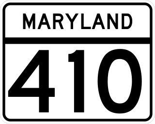
Maryland Route 410 (MD 410) is a state highway in the U.S. state of Maryland and known for most of its length as East–West Highway. The highway runs east to west for 13.92 miles (22.40 km) from MD 355 in Bethesda east to Pennsy Drive in Landover Hills. MD 410 serves as a major east–west commuter route through the inner northern suburbs of Washington, D.C., connecting the commercial districts of Bethesda, Silver Spring, and Hyattsville. In addition, the highway serves the industrial area of Landover Hills and the residential suburbs of Chevy Chase, Takoma Park, Chillum, Riverdale, and East Riverdale. The road also connects many of the arterial highways and freeways that head out of Washington. Additionally, it provides a highway connection to transit and commercial hubs centered around Washington Metro subway stations in Bethesda, Takoma Park, Hyattsville, Silver Spring, and New Carrollton–the latter two of which provide additional connections to MARC and Amtrak trains.

Maryland Route 187 is a state highway in the U.S. state of Maryland. Known as Old Georgetown Road, the highway runs 5.32 miles (8.56 km) from MD 355 and MD 410 in Bethesda north to Executive Boulevard in North Bethesda. MD 187 is a four- to six-lane highway that runs parallel to MD 355 through suburban areas of southern Montgomery County. The highway was paved through Bethesda by 1910. The remainder of MD 187 was constructed in the mid- to late 1920s. The highway was relocated at its northern end and expanded to a divided highway over most of its length in the late 1960s. MD 187's interchanges with Interstate 270 (I-270) and I-495 were built in the late 1950s and early 1960s, respectively; the former interchange was reconstructed in the early 2000s. The northern terminus was cut back from MD 355 to Executive Boulevard in 2016.

Charles Street, known for most of its route as Maryland Route 139, runs through Baltimore and the Towson area of Baltimore County. On the north end, it terminates at an intersection with Bellona Avenue near Interstate 695 (I-695). At the south end, it terminates in Federal Hill in Baltimore. Charles Street is one of the major routes through Baltimore, and is a major public transportation corridor. For the one-way portions of Charles Street, the street is functionally complemented by the parallel St. Paul Street, including St. Paul Place and Preston Gardens, Maryland Avenue, Cathedral Street, and Liberty Street.

Maryland Route 158 is a state highway located in Baltimore County in the U.S. state of Maryland. Known as Bethlehem Boulevard, the state highway runs 2.35 miles (3.78 km) from Riverside Drive in Sparrows Point east to North Point Road in Edgemere. MD 158 parallels Interstate 695 (I-695) along the northern edge of the former Bethlehem Steel complex at Sparrows Point and connects MD 157 with MD 151. Bethlehem Boulevard was constructed as a four-lane divided county highway with several interchanges in the late 1950s. The highway was designated MD 158 in the early 1990s. When I-695 was completely rebuilt and expanded from two to four lanes through Sparrows Point and Edgemere in the late 1990s, MD 158 was also reconstructed as a mostly two-lane highway without interchanges.

Maryland Route 43 is a state highway in the U.S. state of Maryland. Known as White Marsh Boulevard, the state highway runs 8.65 miles (13.92 km) from Interstate 695 (I-695) near Parkville east to MD 150 in Middle River. MD 43 is a four-lane divided highway in eastern Baltimore County that connects the northern and eastern suburbs of Baltimore with the commercial center of White Marsh, where the highway has junctions with I-95 and U.S. Route 40. The state highway was built from west of I-95 to US 40 concurrent with the construction of I-95 in the early 1960s. MD 43 was extended west to Parkville in the early 1990s and east to Middle River in 2006.

Maryland Route 140 is a 49-mile (79 km) state highway in the U.S. state of Maryland. The route runs from U.S. Route 1 and US 40 Truck in Baltimore northwest to the Pennsylvania border, where the road continues into that state as Pennsylvania Route 16. MD 140 passes through the northern part of central Maryland, connecting Baltimore, Pikesville, Reisterstown, Westminster, Taneytown, and Emmitsburg.
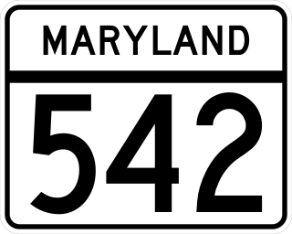
Maryland Route 542 is a state highway in the U.S. state of Maryland. Known for most of its length as Loch Raven Boulevard, the state highway runs 6.33 miles (10.19 km) from MD 147 in Baltimore north to Interstate 695 (I-695) and Cromwell Bridge Road near Towson. MD 542 is a four-lane divided highway that connects portions of Northeast Baltimore with Towson and I-695. The state highway is maintained by the Maryland State Highway Administration in Baltimore County and the Baltimore City Department of Transportation in the city. MD 542 was constructed in the early to mid-1930s. The highway was expanded to a divided highway in Baltimore by 1950 and in Baltimore County in the mid- to late 1950s.

Maryland Route 586 is a state highway in the U.S. state of Maryland. Known as Veirs Mill Road, the highway runs 5.78 miles (9.30 km) from MD 28 and MD 911 in Rockville east to MD 97 in Wheaton. MD 586 is a four- to six-lane northwest–southeast highway through southern Montgomery County. The highway was originally constructed in the mid-1930s. MD 586 was expanded to a divided highway in the mid-1950s.

Maryland Route 188 is a state highway in the U.S. state of Maryland. Known as Wilson Lane, the highway runs 3.25 miles (5.23 km) from MacArthur Boulevard near Glen Echo east to MD 187 in Bethesda. MD 188 runs mainly through residential areas in its course through the affluent suburb of Bethesda. The highway was originally paved in the early 1910s and widened in the mid-1920s.

Maryland Route 191 is a state highway in southwestern Montgomery County in the U.S. state of Maryland.

U.S. Route 1 Alternate is an alternate route of US 1 in the U.S. state of Maryland. The highway runs 3.92 miles (6.31 km) between intersections with US 1 in Arbutus and in Baltimore. US 1 Alt. serves the southwestern Baltimore County community of Halethorpe and connects US 1 with full-access interchanges with Interstate 95 (I-95) and I-695. The Washington Boulevard portion of the alternate route was the original road southwest from Baltimore in the 18th century and was part of the turnpike southwest to Washington, D.C. for much of the 19th century. The highway was paved in the early 1910s, expanded in the late 1910s and late 1920s, and became part of US 1 in 1926. The Caton Avenue portion of the alternate route was improved and expanded in the 1930s to serve as a rerouting of US 1 in southwest Baltimore. US 1 Alt. was created in 1949 when US 1 was moved to its present course through Arbutus and southwest Baltimore. The alternate route's interchanges with I-695 and I-95 were constructed in the late 1950s and mid-1970s, respectively.
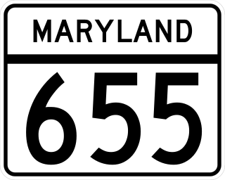
Maryland Route 655 is a state highway in the U.S. state of Maryland. The unsigned highway runs 1.86 miles (2.99 km) from MD 28 east and south to Carrolton Road in the Norbeck area of eastern Montgomery County. MD 655 is an L-shaped route with east–west and north–south segments that parallel MD 28 and MD 97, respectively. The highway and its auxiliary routes form parts of service roads along MD 28 and MD 97. The route follows what were two of the original state roads constructed in the early 1910s. MD 655 was assigned to the north–south segment when MD 97 was relocated in the late 1960s. The highway was extended west when MD 28 was relocated in the early 1980s.


