
Abuja is the capital city of the Federal Republic of Nigeria, strategically situated at the geographic midpoint of the country within the Federal Capital Territory (FCT). As the seat of the Federal Government of Nigeria, it hosts key national institutions, landmarks, and buildings spread across its over 50 districts. It replaced Lagos, as the capital on 12 December 1991.
The Federal Capital Territory (FCT) is a federal territory in central Nigeria. Abuja, the capital city of Nigeria, is located in this territory. The FCT was formed in 1976 from parts of the states of old Kaduna, Kwara, Niger, and Plateau states, with the bulk of land mass carved out of Niger state. The Federal Capital Territory is within the North Central region of the country. Unlike other states of Nigeria, which are headed by elected Governors, it is administered by the Federal Capital Territory Administration, headed by a minister, who is appointed by the president.

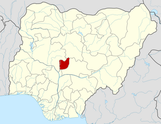
Nasarawa is a state in the North Central region of Nigeria, bordered to the east by the states of Taraba and Plateau, to the north by Kaduna State, to the south by the states of Benue and Kogi, and to the west by the Federal Capital Territory. Named for the historic Nasarawa Emirate, the state was formed from the west of Plateau State on 1 October 1996. The state has thirteen local government areas and its capital is Lafia, located in the east of the state, while a key economic centre of the state is the Karu Urban Area—suburbs of Abuja—along the western border with the FCT.
The Gbari or Gbagyi are an ethnic group found predominantly in Central Nigeria with an estimated population of 12 million spread in four states, including Abuja, and located in thirty local government areas. It is also the name of their language. Members of this ethnic group speak two dialects. While speakers of the dialects were loosely called Gwari by both the Hausa and the Fulani, as well as by Europeans during pre-colonial Nigeria, they prefer to be known as Gbagyi/Gbari. They live in Niger State, the Federal Capital Territory - Abuja, and Kaduna State. They are also found in Nasarawa State, central Nigeria Area. Gbagyi/Gbari is one of the most populous ethnic groups in the middle belt and indigenous to the Federal Capital Territory of Nigeria. This means Gbagyi people are among the bonafide owners of the Nigerian capital city, Abuja.
New Karu is the headquarters of Karu Local Government Area, Nasarawa State. It is one of the largest towns that make up the greater Karu urban centre in Nasarawa state which is a conurbation consisting of towns and villages along the Keffi-Abuja expressway making up the Nyanya-Masaka urban centre. The major towns that make up this urban area are;
Sanga is a Local Government Area in southern Kaduna State, Nigeria. Its headquarters is in the town of Gbantu. The Local Government Council is chaired by Bisallah Malam. It has an area of 1,821 km2 and had a population of 151,485 as at the 2006 census. The postal code of the area is 801.
Jaba is a Local Government Area in southern Kaduna State, Nigeria. It covers an area of 531 km2. It is located close to the Jos Plateau region and Abuja in the central part of Nigeria in West Africa. The local government capital is in the town of Kwoi. The postal code of the area is 801. The Chairman of the local government oversee both economic and developmental activities in the area.
Karu is a Local Government Area in Nasarawa State, central Nigeria. It is close in proximity to the Federal Capital Territory of Nigeria. It has an area of 2,640 km2. Karu local government has its headquarters in New Karu town. It was originally built to house the capital's civil servants and lower income families, but had no running water or good sanitation system. Karu has grown in population beyond its original planned capacity. Ensure Administrative convenience and bring government closer to the grass root people, Karshi Development Area was created with its administrative secretariat at Uke.
Toto is a Local Government Area in Nasarawa State, Nigeria. Its headquarters is in the town of Toto.

Ado is a town in Nasarawa, central Nigeria. It is a district of Karu Local Government Area, Nasarawa State and is among the towns that make up the Karu urban area, a conurbation of towns stretching to Nigeria's Federal Capital Territory.
Mararaba is a town in Nasarawa State, central Nigeria. It is a district of Gurku Chiefdom under Karu Local Government Area, Nasarawa State and is among the towns that make up the Karu urban area, a conurbation of towns stretching to Nigeria's Federal Capital Territory. Its neighbouring towns are:
New Nyanya is a town in Nasarawa State. It is a district of Karu Local Government Area, Nasarawa State, and is among the towns that make up the Karu Urban Area, a conurbation of towns stretching into the Federal Capital Territory (FCT). New Nyanya is loosely considered as part of the metropolitan area of Abuja.
Kurunduma is a suburban town in Abuja Municipal area council, Nigeria. It is a major town around Asokoro Area, a conurbation of towns within Abuja's metropolitan area. Its neighbouring towns are:
The Karu Urban Area is an urban area in central Nigeria. The urban area is majorly located in the Nigerian state of Nasarawa, but with some parts stretching into the boundaries of the Federal Capital Territory (FCT). It has an area of 40,000 hectares (400 km2) and a population of some 2 million.
Auta Balefi is a fast developing district in central Nigeria. This town is located in Karu Local Government Area of Nasarawa State. It lies close to Abuja, the capital city of Nigeria in the Federal Capital Territory of Nigeria. Popular institutions located in this town include, Birgham University Campus (ECWA); Living Faith Church, Goshen City; The Redeemed Christian Church of God, Redemption Camp, Auta gurgu; and some developing estates. This district is rapidly growing due to its closeness to the Federal Capital Territory, Abuja.
One Man Village is a village in central Nigeria. It is found in Karu Local Government area of Nasarawa State. It lies close to Abuja, Federal Capital Territory, Nigeria.
Gade (Gad) is a Gadoid language of Nigeria. Glottolog 4.7 (2022) classifies it as an independent branch of Benue-Congo rather than as a Nupoid language of the Gade people.
The Ombatse group is a militia group in Nasarawa Egon, a Local Government Area of Nasarawa State, northern Nigeria. In May 2013, the group was reported to have killed 74 police officers and 10 State Security Service officers. The deadly attack was led by the leader of the group, Baba Alakyo, the chief priest of Alakyo Village of Nasarawa Egon.

New Karshi is a town in Karu Local Government Area of Nasarawa State, Nigeria, founded in the 1980s by Muhammadu Bako II. It is a semi-autonomous local government created out of Karu LGA as Karshi Development area with the administrative secretariat in Uke. Karshi has a local government chairman as its administrative head and a seat in the Nasarawa State House of Assembly. Emir of Karshi Emirate, Alhaji (Dr) Muhammadu Sani Bako III, a first class chief is the traditional head of New Karshi. It has a population of about 30,000 people. The predominant tribes are Gwandara, Gbagyi, Gade, Bassa and Hausa.
Gade people, also known as BÀBYẸ̀, are one of the ethnic groups in Nigeria. They can be found in Kano State, Kogi State, Lagos State, Jigawa State, Niger State, Kwara State, Niger State, the Federal Capital Territory (Abuja) and Nassarawa State. The Gadé language belongs to GADOID language Classification Scheme. Gade is considered one of the ancient and oldest languages, not just in Nigeria but also in Germany, China, Togo, England, France just to mention but a few, and also one of the existing languages in Nigeria that have some of its earlier History written and documented in Greek Language. The Gade people arrived at the present day Nigeria around 36,000 BCE with codified Philosophy and religion called Gaboism and Gomoism. The Gaboism consist of Norms, philosophy, education, Values, Laws and Mores, Traditions and Worships while the Gomoism have to do with rulership and leadership structure in all Gade Nations. These religions are still paramount and practicing till today. The Supreme Court in Gade Nations is called Ụdáá gbòngbòńkí headed by the Gómó and some Bátsákpá during proceedings and the system of Administration or Governance in Gade Nations is called Constitutional Mornachy in a Confederate Society. Importantly, The Gade Native Speakers are called Bábyẹ̀ and the style of speaking and writing GADE is called Rìbyẹ̀ which is literally mean Phonetics. A Gademan/Gadewoman is called Byēní. Ụbyēní/Ụbyēnú is used when referring to the Gademan/Gadewoman while Bàbyẹ̀ is the plural form of byēní.
