This article may be expanded with text translated from the corresponding article in French. (August 2015)Click [show] for important translation instructions.
|
Maskinongé | |
|---|---|
 | |
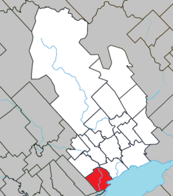 Location within Maskinongé RCM. | |
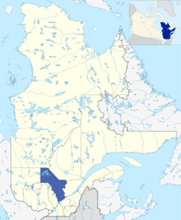
 Maskinongé Location in central Quebec. | |
| Coordinates: 46°14′N73°01′W / 46.233°N 73.017°W Coordinates: 46°14′N73°01′W / 46.233°N 73.017°W [1] | |
| Country | |
| Province | |
| Region | Mauricie |
| RCM | Maskinongé |
| Constituted | April 25, 2001 |
| Government | |
| • Mayor | Roger Michaud |
| • Federal riding | Berthier—Maskinongé |
| • Prov. riding | Maskinongé |
| Area | |
| • Total | 74.40 km2 (28.73 sq mi) |
| • Land | 74.55 km2 (28.78 sq mi) |
| There is an apparent contradiction between two authoritative sources | |
| Population (2011) [3] | |
| • Total | 2,253 |
| • Density | 30.2/km2 (78/sq mi) |
| • Pop 2006-2011 | |
| • Dwellings | 1,093 |
| Time zone | UTC−5 (EST) |
| • Summer (DST) | UTC−4 (EDT) |
| Postal code(s) | |
| Area code(s) | 819 |
| Highways | |
| Website | www |
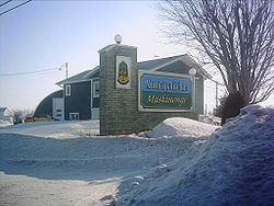
Maskinongé is a municipality in the Mauricie region of the province of Quebec in Canada.
Mauricie is a traditional and current administrative region of Quebec. La Mauricie National Park is contained within the region, making it a prime tourist location. The region has a land area of 35,855.22 km² and a 2006 census population of 258,928 residents. Its largest cities are Trois-Rivières and Shawinigan.

The provinces and territories of Canada are sub-national governments within the geographical areas of Canada under the authority of the Canadian Constitution. In the 1867 Canadian Confederation, three provinces of British North America—New Brunswick, Nova Scotia, and the Province of Canada —were united to form a federated colony, becoming a sovereign nation in the next century. Over its history, Canada's international borders have changed several times, and the country has grown from the original four provinces to the current ten provinces and three territories. Together, the provinces and territories make up the world's second-largest country by area.

Quebec is one of the thirteen provinces and territories of Canada. It is bordered to the west by the province of Ontario and the bodies of water James Bay and Hudson Bay; to the north by Hudson Strait and Ungava Bay; to the east by the Gulf of Saint Lawrence and the province of Newfoundland and Labrador; and to the south by the province of New Brunswick and the U.S. states of Maine, New Hampshire, Vermont, and New York. It also shares maritime borders with Nunavut, Prince Edward Island, and Nova Scotia. Quebec is Canada's largest province by area and its second-largest administrative division; only the territory of Nunavut is larger. It is historically and politically considered to be part of Central Canada.


