
Kafue is a town on the T2 road in the Lusaka Province of Zambia and it lies on the north bank of the Kafue River, after which it is named. It is the southern gateway to the central Zambian plateau on which Lusaka and the mining towns of Kabwe and the Copperbelt are located.
Kalabo is an urban centre and the seat of Kalabo District, in the Western Province of Zambia.

The Great North Road is a major route in Zambia, running north from Lusaka through Kabwe, Kapiri Mposhi, Serenje, Mpika, Isoka and Nakonde to the border with Tanzania. The entire route is designated as the T2 road on Zambia's road network. It forms the Zambian section of the Tanzam Highway.

Union Turnpike is a thoroughfare stretching across part of Long Island in southern New York state, mostly within central and eastern Queens in New York City. It runs from Myrtle Avenue in Glendale, Queens, to Marcus Avenue in North New Hyde Park, Nassau County, about 1 mile (1.6 km) outside New York City border.
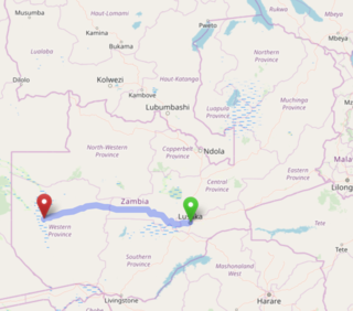
The Lusaka–Mongu Road of Zambia runs 580 km from the capital, Lusaka, to Mongu, capital of the Western Province. It connects that province to the rest of the country, as well as being one of two routes to the south-west extremity of North-Western Province. It also serves as the main highway of the western half of Central Province. The entire route from Lusaka to Mongu is designated as the M9 road.

The T1 or Lusaka–Livingstone Road is the main highway of the Southern Province of Zambia. It begins 55 kilometres south of the city of Lusaka and heads south-west to the principal tourist destination, Victoria Falls in Livingstone, via Mazabuka, Monze, Choma and Kalomo, measuring approximately 430 kilometres (267 mi). The entire route is part of Trans-African Highway network number 4 or Cairo-Cape Town Highway between Cairo and Cape Town.

Fresh Pond Parkway is a historic park and parkway on the western end of Cambridge, Massachusetts, part of the Metropolitan Park System of Greater Boston. The parkway was built in 1899 and added to the National Register of Historic Places in 2005.

Lusaka is the capital and largest city of Zambia. It is one of the fastest-developing cities in southern Africa. Lusaka is in the southern part of the central plateau at an elevation of about 1,279 metres (4,196 ft). As of 2019, the city's population was about 3.3 million, while the urban population is estimated at 2.5 million in 2018. Lusaka is the centre of both commerce and government in Zambia and connects to the country's four main highways heading north, south, east, and west. English is the official language of the city administration, while Bemba, Tonga, Lenje, Soli, Lozi, and Nyanja are the commonly spoken street languages.

The Cairo–Cape Town Highway is Trans-African Highway 4 in the transcontinental road network being developed by the United Nations Economic Commission for Africa (UNECA), the African Development Bank (AfDB), and the African Union. The route has a length of 10,228 km (6,355 mi) and links Cairo in Egypt to Cape Town in South Africa.

Heroes National Stadium is a multi-purpose stadium in Lusaka, Lusaka Province, Zambia. It is currently used mostly for football matches and hosts the home matches of the Zambia national football team. The stadium holds 60,000 spectators. It opened in 2014. The name of the stadium refers to the 1993 Zambia national football team air disaster which took the lives of most of its national football team.

AB Bank Zambia is a commercial bank in Zambia, licensed by the Bank of Zambia and by the national banking regulator. It is a member of AccessHolding, a banking group which operates a network of commercial banks and microfinance institutions in developing and transition countries with a target group focus on micro, small and medium-sized enterprises.
Garden Township, is a neighborhood in the city of Lusaka, the capital of Zambia.
Chelston, also Chelstone or Chakunkula, is a neighborhood in Zambia's capital city, Lusaka. Before the 1960s Chelstone was an separate town until it was annexed into the greater city of Lusaka.

Cathedral Hill is a neighborhood in the city of Lusaka, the capital of Zambia.
Ridgeway is a neighborhood in the city of Lusaka, the capital of Zambia.
Nakonde is a town in the Muchinga Province of Zambia, on the border with Tanzania. It is at the northern end of Zambia's Great North Road. It is the principal commercial and political headquarters of Nakonde District and the district headquarters are located here.

The T2 is a trunk road in Zambia. The road runs from the Tunduma border with Tanzania via Mpika, Kabwe and Lusaka to the Chirundu border with Zimbabwe. The road is the longest route of the country, as it is approximately 1,155 kilometres (718 mi). The route from Mpika to Kafue is a toll road. The route from Tanzania to Lusaka is Zambia's Great North Road and is part of the Tanzam Highway.
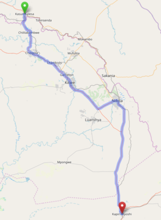
The T3 is a Trunk Road in Zambia. The road runs from Kapiri Mposhi via Ndola, Kitwe and Chingola to Kasumbalesa on the border with DR Congo. The entire route is a toll road.
