Mauerkirchen | |
|---|---|
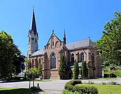 Church of the Assumption of the Virgin Mary | |
 Coat of arms | |
 Mauerkirchen Location within Austria | |
| Coordinates: 48°11′27″N13°08′07″E / 48.19083°N 13.13528°E | |
| Country | Austria |
| State | Upper Austria |
| District | Braunau am Inn |
| Government | |
| • Mayor | Horst Gerner (SPÖ interim) |
| Area | |
• Total | 3.09 km2 (1.19 sq mi) |
| Elevation | 407 m (1,335 ft) |
| Population (2018-01-01) [2] | |
• Total | 2,566 |
| • Density | 830/km2 (2,150/sq mi) |
| Time zone | UTC+1 (CET) |
| • Summer (DST) | UTC+2 (CEST) |
| Postal code | 5270 |
| Area code | 07724 |
| Vehicle registration | BR |
| Website | https://www.mauerkirchen.ooe.gv.at/ |
Mauerkirchen is a municipality in the district of Braunau am Inn in the Austrian state of Upper Austria.
