
Calauag, officially the Municipality of Calauag, is a 1st class municipality in the province of Quezon, Philippines. According to the 2020 census, it has a population of 71,809 people.

The Upper Marikina River Basin Protected Landscape is a protected area in the Province of Rizal in the Philippines, which forms the upper area of the drainage basin of the Marikina River.
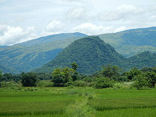
Sibalom Natural Park is a 5,511.47-hectare (13,619.1-acre) protected area in the Philippines on the island of Panay in the municipality of Sibalom, Antique. It was proclaimed a natural park on 23 April 2000. It is considered one of the last remaining lowland rainforests on Panay.
The Manleluag Spring Protected Landscape is a protected area containing natural hot springs in the Ilocos Region of the Philippines. It is one of 34 protected landscapes in the Philippines located in the municipality of Mangatarem, Pangasinan in the west-central area of the island of Luzon.

The Magapit Protected Landscape is a protected area of forested limestone hills and grasslands in the Cagayan Valley of northern Luzon island in the Philippines. It covers an area of 3,403.62 hectares in northeastern Cagayan province straddling the municipalities of Lal-lo and Gattaran. The park was established as a game refuge and bird sanctuary on 15 August 1947 covering an initial area of 4,554 hectares declared through Administrative Order No. 10 by President Manuel Roxas. On 23 April 2000, the park was redesignated as a protected landscape area under the National Integrated Protected Areas System Act through Proclamation No. 285 signed by President Joseph Estrada. The park is a component of the Northeastern Cagayan Key Biodiversity Area and also contains the Lal-lo and Gattaran Shell Middens, a proposed World Heritage Site.
The Libunao Protected Landscape, also known as the Libunao Spring Protected Landscape, is a protected area in the Ilocos Region of the island of Luzon in the Philippines located on the western foothills of the Ilocos Mountain Range. It protects the Libunao Spring and surrounding forests, as well as the Nagcullooban River watershed. First proclaimed as the Libunao Spring Watershed Forest Reserve in 1931 through Proclamation No. 410 issued by Governor-General Dwight F. Davis, the park was reestablished as a protected landscape area under the National Integrated Protected Areas System in 2000 through Proclamation No. 280 signed by President Joseph Estrada. The Libunao watershed is the source of water supply for domestic use and irrigation of the surrounding farms and communities of northern Ilocos Sur province.
The Lidlidda Protected Landscape, also known as the Lidlidda–Banayoyo Protected Landscape, is a protected area of natural springs and surrounding mountain forests in Ilocos Sur on the island of Luzon in the Philippines. It is an important watershed providing the agricultural and household water requirements of the communities in the municipalities of Lidlidda and Banayoyo. It was established in 1936 as the Lidlidda Watershed Forest Reserve through Proclamation No. 79 signed by President Manuel Luis Quezon with an initial area of 1,228 hectares. In 2000, under the National Integrated Protected Areas System, it was redesignated as a protected landscape area covering its present size of 1,157.44 hectares.
The Santa Lucia Protected Landscape, also known as the Salcedo Protected Landscape, is a protected area located in the foothills of the Cordillera Central mountain range in the Ilocos Sur province of the Philippines. It protects an important watershed that serves as the water source for the surrounding communities in the municipality of Salcedo. It had an initial area of 174 hectares proclaimed as the Santa Lucia Watershed Forest Reserve in 1938 through Proclamation No. 333 issued by President Manuel Luis Quezon. In 2000, the forest reserve was reestablished as a protected landscape area under the National Integrated Protected Areas System with the signing of Proclamation No. 296 by President Joseph Estrada.
The Bigbiga Protected Landscape is a protected landscape of forested hills, open grasslands and natural springs in Ilocos Sur in the northwestern part of the island of Luzon, Philippines. It is one of five protected landscape areas in the Ilocos Region under the Philippines' National Integrated Protected Areas System. The park has a total area of 135.71 hectares located entirely within the municipality of Narvacan. It was created in 1939 as the Bigbiga Spring Watershed Forest Reserve by virtue of Proclamation No. 431 signed by President Manuel Luis Quezon. In 2000, it was reclassified as a protected landscape by Proclamation No. 290.
The Mati Protected Landscape is a protected area located in Davao Oriental on the southern Philippine island of Mindanao. It protects the watershed in Mati which is the source of water supply for the city's Mati Waterworks System. The protected area was established in 1967 when 890 hectares of forest in Central Mati was proclaimed as the Mati Watershed Forest Reserve through Proclamation No. 222 issued by President Ferdinand Marcos. Under the National Integrated Protected Areas System, the area was reclassified as a protected landscape with the signing of Proclamation No. 912 in 2005 by President Gloria Arroyo.
The Mainit Hot Springs Protected Landscape is a protected landscape area located in the province of Davao de Oro on the island of Mindanao in the Philippines. It preserves the sulfuric hot springs and surrounding forest in Nabunturan municipality which also contains the headwaters of the Manat River, a source of water supply for surrounding villages. First declared a national park in 1957 by virtue of Proclamation No. 466 by President Carlos P. Garcia, it had an initial area of 1,381 hectares. Under the National Integrated Protected Areas System, it was reclassified as a protected landscape through Proclamation No. 320 issued in 2000 by President Joseph Estrada. The hot springs are a popular ecotourist attraction in Davao de Oro. Its name "Mainit" is a Filipino word which means hot.
The Buenavista Protected Landscape is a conservation area and an archaeological site located on Bondoc Peninsula in the southern Luzon province of Quezon in the Philippines. It conserves an important watershed area composed of secondary-growth forest, grassland and coconut land in the rural village of Buenavista within the coastal municipality of Mulanay. The area was primarily set aside for watershed protection and timber production in 1937 covering approximately 356 hectares. In 2000, it was reestablished as a protected landscape area under the National Integrated Protected Areas System. The area is known as the site of an ancient village containing unique limestone graves discovered in 2011. The protected area, including the limestone tombs of Kamhantik were recommended by various scholars to be included in the tentative list of UNESCO World Heritage Sites, yet no government or private entities have yet to file a tentative nomination to the UNESCO Secretariat.
The Amro River Protected Landscape is a protected landscape area located in the province of Aurora in eastern Central Luzon in the Philippines. It preserves the primary water source for agricultural, power generation and domestic consumption of the remote northern Auroran communities on the Pacific coast. The area was first established in 1990 as the Amro River Watershed Forest Reserve to protect, maintain and improve the water yield of the Amro River as declared through Proclamation No. 633 by President Corazón Aquino. In 2000, the forest reserve was reclassified as a protected landscape under the National Integrated Protected Areas System with the enactment of Proclamation No. 274 by President Joseph Estrada. It is one of five declared protected areas of the Philippines in Aurora.

The Dinadiawan River Protected Landscape is a protected area covering the stretch of the Dinadiawan River from its headwaters in the Sierra Madre mountain range to its mouth on the Philippine Sea coast of the village of Dinadiawan in Aurora province, Philippines. The park covers an area of 3,371.332 hectares and includes its surrounding forested mountains, waterfalls and springs in Dipaculao municipality. It is composed of 2,645 hectares of forested area, 323 hectares of grassland, 151 hectares of forested shrubland, 144 hectares of cultivated area, and 108 hectares of the Dinadiawan River. Its forest cover consists primarily of dipterocarp trees like tanguile, mayapis, white lauan, red lauan and bagtikan. It serves as a habitat of wild fauna such as the Philippine deer, Philippine long-tailed macaque, Philippine warty pig, spotted wood kingfisher and pygmy swiftlet.
The Simbahan–Talagas Protected Landscape is a protected area in northern Aurora, Philippines that preserves a major watershed in the Sierra Madre mountain range of Central Luzon. It contains the headwaters of the Simbahan and Talagas rivers, including the Sangay River and Umihiem Creek in Dinalungan municipality which empty into the Casiguran Sound. A large portion of the park is under forest cover, while the remaining areas are cultivated land, shrubland, grassland, built-up area and river-wash area. Some of the park's fauna include the Philippine deer, Philippine long-tailed macaque, and an abundant species of avifauna. Its location in north central Sierra Madre is covered by dipterocarp forest, composed of Shorea almon, Shorea polysperma (tanguile), Shorea squamata (mayapis), Shorea contorta, Shorea negrosensis, and Parashorea malaanonan (bagtikan).
The Talaytay Protected Landscape is a protected area in northern Aurora, Philippines that preserves the Talaytay River watershed in the Sierra Madre mountain range of Central Luzon. It encompasses an area of 3,526.29 hectares stretching from the rugged interior containing the headwaters of the Talaytay River to its mouth at the lowland area of Dinalungan municipality. The park is known to harbor several important flora of the dipterocarp variety, including Dipterocarpus grandiflorus (apitong), Shorea polysperma (tanguile), Shorea squamata (mayapis), Shorea contorta, Shorea negrosensis, Parashorea malaanonan (bagtikan), and Shorea philippinensis (mangasinoro). It is home to a number of wildlife such as the Philippine deer, Philippine long-tailed macaque and some avifauna species.
The Calbayog Pan-as–Hayiban Protected Landscape, also known as the Calbayog Watershed, is a watershed and protected area located northwest of the city of Calbayog, Province of Samar in Oquendo District between Tinambacan District and San Isidro, Northern Samar in the Philippines. It is a mountainous region in the Tanaoan Ridge within the Mount Zamal Range that divides the three provinces of Samar. The protected area extends along the valley of the Hayiban River, the primary source of water for the Calbayog Water District. It consists of old growth trees and a system of rivers, waterfalls and streams capable of generating 2,279 liters per day. It also contains the Pan-as Falls and surrounding landscape which also supplies hydroelectric power to the city. The area was declared a forest reserve in 1967 known as the Pan-as Falls–Hayiban Watershed Forest Reserve with a total area of 7,832 hectares. In 1998, through Proclamation No. 1158 issued by President Fidel Ramos, the watershed was reclassified as a protected landscape. It is one of four protected areas in the island of Samar.

Mounts Banahaw–San Cristobal Protected Landscape is a protected landscape park in the Calabarzon region of the Philippines, 120 kilometres (75 mi) south of Manila. It is the second largest protected area in Calabarzon, after the Upper Marikina River Basin Protected Landscape, with an area of 10,900.59 hectares. The park is located at the border of Laguna and Quezon provinces and includes the features it is named after: Mount Banahaw and, 7 kilometres (4.3 mi) to its west, Mount San Cristobal.

The Angat Watershed Forest Reserve is a conservation area that protects the drainage basin in the southern Sierra Madre range north of Metro Manila in the Philippines where surface water empties into the Angat River and its distributaries. It is spread over an area of 62,309 hectares in the eastern portion of Bulacan and northern Rizal province at an altitude of between 490 and 1,206 metres. The conservation area also extends to the provinces of Nueva Ecija and Quezon and is centered on an artificial lake created by the Angat Dam which, together with the Ipo Dam located 7.5 kilometres (4.7 mi) downstream, supply 97% of the water requirement of Metro Manila via an aqueduct system to the La Mesa Dam and Reservoir and the Balara Filtration Plant in Quezon City. The Angat Dam and Reservoir is also a major source of hydroelectricity for Metro Manila and surrounding provinces, contributing some 200 megawatts to the Luzon grid. The watershed is a popular birdwatching site and is a biodiversity hotspot containing most of the remaining closed-canopy forests in Central Luzon.

The Upper Agno River Basin Resource Reserve is a protected area located on the southeast flank of the Cordillera Central in the Philippine province of Benguet along its border with Ifugao and Nueva Vizcaya. It is a resource reserve located high in the Central and Polis ranges protecting the headwaters of the Agno River. According to section 4 of the National Integrated Protected Areas System Act, a resource reserve is an extensive and relatively isolated area designated as such to preserve the natural resources of the area. The reserve comprises 77,561 hectares of the catchment area that feeds the Ambuklao and Binga dams, two of the country's oldest hydroelectric plants that supply power to the city of Baguio and entire Benguet province. Upper Agno is north of and contiguous with the Lower Agno Watershed Forest Reserve that preserves the immediate downstream of the Binga Dam where the Agno River is impounded by a third dam, the San Roque Dam, the largest in the Philippines and the main source of water, electric energy and irrigation for surrounding regions in Luzon.
