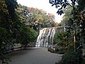
Hinulugang Taktak

Last updated

Hinulugang Taktak Protected Landscape
IUCN category V (protected landscape/seascape)
Hinulugang Taktak.jpg
Hinulugang Taktak
Philippines relief location map (Luzon).svg
Red pog.svg
Location in the Philippines
Philippines relief location map (square).svg
Red pog.svg
Hinulugang Taktak (Philippines)
Location Rizal, Philippines
Nearest city Antipolo
Coordinates 14°35′41″N121°10′03″E / 14.59472°N 121.16750°E / 14.59472; 121.16750 Coordinates: 14°35′41″N121°10′03″E / 14.59472°N 121.16750°E / 14.59472; 121.16750
Area3.2 hectares (7.9 acres)
Established15 July 1952 (Recreation area)
18 September 1990 (National park)
17 November 2000 (Protected landscape)
Visitors843,000(in 2018 [1] )
Governing body Rizal Provincial Government
Department of Environment and Natural Resources

Hinulugang Taktak Protected Landscape, also known as Hinulugan Taktak, is a protected area located in Rizal, Philippines. Initially assigned as a recreation area, the waterfall area has been designated as a national park by virtue of Republic Act No. 6964 in 1990. [2] Ten years later, it became a protected landscape in accordance to Proclamation No. 412. [3] It is being managed by the Department of Environment and Natural Resources and the Rizal Provincial Government. [4] As of 2003 and 2004, Hinulugang Taktak is the second most popular national park in the Philippines in terms of number of visitors. [5]

Contents

History

Folk knowledge has it that the name was derived from a large bell (taktak) which was thrown (hinulog) into the falls during the 15th century or the 16th century because the local villagers considered it too loud. Since then, it has become known as Hinulugang Taktak or the place where the bell fell. [6] [7] Being one of Antipolo's iconic destinations, the other being the Antipolo Cathedral, [8] Hinulugang Taktak is featured in the hymn Antipolo composed by German San Jose in 1929. [6] The lyrics indicate that even at the time, it was already a popular recreational area. [9]

On 15 July 1952, five lots with a total area of 0.85 hectares (2.1 acres) were reserved as a recreation area under the administration of the Antipolo Municipal Government. The largest lot came from the property of James O'Hara and Concepcion Francisco, while the rest of the lots came from the properties of Concepcion Leyba y Banson and the Manila Railroad Company. [10] Beginning in the 1960s, the waters have been slowly polluted. To stop the degradation of the falls, it was designated as a national park on 18 September 1990. As part of its conversion into a national park, the reserved area was increased to 3.2 hectares (7.9 acres). [2] [7] The rehabilitation began as early as 1991. Seven years later, up to 75 percent of the area has been restored at a cost exceeding 45 million pesos. [11]

On 17 November 2000, it became a protected landscape in accordance to Proclamation No. 412, effectively transferring its administration to the Department of Environment and Natural Resources and the Rizal Provincial Government. It also mandated the use of the trust fund through the Integrated Protected Area Fund System to add to the limited funding for the park from the national government. [3] [12] Renewed efforts were made to rehabilitate the area starting 2009 with an initial three-year budget of 100 million pesos, and in 2013. [13] [14] However, an oil spill in 2015 forced the closure of the park, and to further intensify rehabilitation efforts. [15] [16] Private institutions also helped in the restoration, including photo exhibits, bamboo planting and other re-greening efforts in the area. [17] [18] Eleven days after the oil spill, the park was reopened to visitors. [19] [20]

On February 13, 2020 the Hinulugang Takatak had reopened to the public after a long year rehabilitation and featured recreational activities are spider web platform, hanging bridges, and a wall climbing facility. [21]

Geography and geology

Located around 1.7 kilometres (1.1 mi) from the Antipolo Cathedral, the falls can be accessed through Taktak Road. The park contains the headwaters of the Sapang Baho River (also known as Antipolo River and Taktak River), which flows to Laguna de Bay through the Manggahan Floodway. Due to the accumulated water pollution, it was deemed unsafe for recreational purposes such as swimming. [22] The falls have a height of 21.5 meters (70.5 feet) and a width of 25.8 meters (84.6 feet). The rocks beneath the Quaternary soil are Miocene layers. However, the area itself is susceptible to erosion, landslides, and earthquakes. [7]

Biology and ecology

There are at least 11 species of trees in the area, including Senna spectabilis , Cananga odorata , Swietenia macrophylla , Pterocarpus indicus , Chrysophyllum cainito , Artocarpus heterophyllus , Persea americana , Sandoricum koetjape , Mangifera indica , Averrhoa bilimbi , and Cocos nucifera . While there is no report of endemic or endangered species present, animal species in the area include Varanus salvator , Python reticulatus , and Draco volans . [7]

Recreation

Facilities began to be built as part of the continuing rehabilitation effort starting in 2002. Due to water pollution, the river itself was deemed unsafe for swimming. As an alternative, a nearby pool was constructed for swimmers. [7] Private resorts and hotels have also been built near the area. [23] Since its designation as a national park and its consequent rehabilitation, visitors have steadily increased from 45,563 in 1995 to 83,431 in 2004. This raised the profile of Hinulugang Taktak as the nation's second most popular national park, following the Ninoy Aquino Parks and Wildlife Center. [5] As of 2008, it also recorded the third largest income for any protected area in the Philippines with 11.1 million pesos, following the Ninoy Aquino Parks and Wildlife Center (first) and the Mount Apo Natural Park (second). [24]

Related Research Articles

<span class="mw-page-title-main">Rizal (province)</span> Province in Calabarzon, Philippines

Rizal, officially the Province of Rizal, is a province in the Philippines located in the Calabarzon region in Luzon. Its capital is the city of Antipolo. It is about 16 kilometres (9.9 mi) east of Manila. The province is named after José Rizal, one of the main national heroes of the Philippines. It is bordered by Metro Manila to the west, Bulacan to the north, Quezon to the east and Laguna to the southeast. The province also lies on the northern shores of Laguna de Bay, the largest lake in the country. Rizal is a mountainous province perched on the western slopes of the southern portion of the Sierra Madre mountain range.

<span class="mw-page-title-main">Calabarzon</span> Administrative region of the Philippines

Calabarzon, formally known as the Southern Tagalog Mainland, is an administrative region in the Philippines, designated as Region IV-A. The region comprises five provinces: Batangas, Cavite, Laguna, Quezon, and Rizal; and one highly urbanized city, Lucena. The region is the most populous region in the Philippines according to the Philippine Statistics Authority, having over 16.1 million  inhabitants in 2020, and is also the country's second most densely populated after the National Capital Region.  The region is situated southeast of Metro Manila, and is bordered by Manila Bay to the west, Lamon Bay and the Bicol Region to the east, the Tayabas Bay and Sibuyan Sea to the south, and Central Luzon to the north. It is home to places like Mount Makiling near Los Baños, Laguna, and the Taal Volcano in Batangas.

<span class="mw-page-title-main">Laguna de Bay</span> Largest lake in the Philippines

Laguna de Bay, also known as Laguna Lake, is the largest lake in the Philippines. It is located southeast of Metro Manila, between the provinces of Laguna to the south and Rizal to the north. A freshwater lake, it has a surface area of 911–949 km², with an average depth of about 2.8 meters and an elevation of about one meter above sea level. The lake is shaped like a crow's foot, with two peninsulas jutting out from the northern shore and filling the large volcanic Laguna Caldera. In the middle of the lake is the large island of Talim.

<span class="mw-page-title-main">Pasig River</span> Estuary in Metro Manila, Philippines

The Pasig River is a water body in the Philippines that connects Laguna de Bay to Manila Bay. Stretching for 25.2 kilometers (15.7 mi), it bisects the Philippine capital of Manila and its surrounding urban area into northern and southern halves. Its major tributaries are the Marikina River and San Juan River. The total drainage basin of the Pasig River, including the basin of Laguna de Bay, covers 4,678 square kilometers (1,806 sq mi).

<span class="mw-page-title-main">San Jose del Monte</span> Component City in Bulacan, Philippines

San Jose del Monte, officially the City of San Jose del Monte, is a 1st class component city in the province of Bulacan, Philippines. According to the 2020 census, it has a population of 651,813 people, making it the largest local government unit within the province of Bulacan and Central Luzon and the 18th most populated city in the Philippines. The City of San Jose del Monte had been proclaimed as a highly urbanized city on December 4, 2020, by the virtue of Proclamation No. 1057, signed by President Rodrigo Duterte and shall take effect after the ratification in a plebiscite.

<span class="mw-page-title-main">Pasig</span> Highly Urbanized City in Metro Manila, Philippines

Pasig, officially the City of Pasig, is a 1st class highly urbanized city in the National Capital Region of the Philippines. According to the 2020 census, it has a population of 803,159 people. 

<span class="mw-page-title-main">Marikina</span> Highly Urbanized City in Metro Manila, Philippines

Marikina, officially the City of Marikina, is a 1st class highly urbanized city in the National Capital Region of the Philippines. According to the 2020 census, it has a population of 456,159 people. 

<span class="mw-page-title-main">Antipolo</span> Capital of Rizal, Philippines

Antipolo, officially the City of Antipolo, is a 1st class component city and capital of the province of Rizal, Philippines. According to the 2020 census, it has a population of 887,399 people.  It is the most populous city in the Calabarzon region, and the seventh most-populous city in the Philippines.

<span class="mw-page-title-main">San Mateo, Rizal</span> Municipality in Rizal, Philippines

San Mateo, officially the Municipality of San Mateo, is a 1st class municipality in the province of Rizal, Philippines. According to the 2020 census, it has a population of 273,306.

<span class="mw-page-title-main">Taytay, Rizal</span> Municipality in Rizal, Philippines

Taytay, officially the Municipality of Taytay, is a 1st class municipality in the province of Rizal, Philippines. It is also known as the Garments Capital of the Philippines. Most occupation of the residents are related to supplying different types of garments related things like blouses, pants, dresses and the garment itself at a very low cost. According to the 2020 census, it has a population of 386,451 people.  It is the 2nd most populous municipality in the country, after Rodriguez, Rizal.

The Sapang Baho River is a river system that runs through Rizal Province and Marikina in the Philippines. The name, when literally translated, means "smelly creek." It is one of 21 tributaries of Laguna de Bay and is regularly monitored by the Laguna Lake Development Authority (LLDA) through one of its 15 river monitoring stations. Among its headwaters are the Hinulugang Taktak falls on the Taktak River in Antipolo city, once a famed tourist destination in the days before urbanization and pollution.

<span class="mw-page-title-main">Ninoy Aquino Parks and Wildlife Center</span> Zoo in Quezon City, Philippines

The Ninoy Aquino Parks and Wildlife Center is a 23.85-hectare (58.9-acre) Protected Area located in Diliman, Quezon City, Philippines. It was named after Benigno "Ninoy" Aquino Jr. The Ninoy Aquino Parks & Wildlife Center has a lagoon, an aquarium, a playground, botanical garden and a Wildlife Rescue Center, which the Department of Environment and Natural Resources uses as a temporary shelter where confiscated, retrieved, donated, sick, abandoned, and injured wild animals are placed to be taken care of. The park houses several indigenous plants and animals such as crab-eating macaques, water monitors, Philippine deer, binturongs, Palawan bearded pigs and several varieties of birds.

<span class="mw-page-title-main">Upper Marikina River Basin Protected Landscape</span>

The Upper Marikina River Basin Protected Landscape is a protected area in the Province of Rizal in the Philippines, which forms the upper area of the drainage basin of the Marikina River.

<span class="mw-page-title-main">Las Piñas–Parañaque Critical Habitat and Ecotourism Area</span> Protected coastal area in Metro Manila, Philippines

The Las Piñas–Parañaque Critical Habitat and Ecotourism Area (LPPCHEA), also known as the Las Piñas–Parañaque Wetland Park, is a protected area at the coasts of the cities of Las Piñas and Parañaque in Metro Manila, Philippines. The entire wetland is a declared Ramsar site under the Ramsar Convention of UNESCO.

<span class="mw-page-title-main">La Mesa Watershed Reservation</span> Protected area in Metro Manila, Philippines

The La Mesa Watershed Reservation is a protected area that preserves the only major watershed in Metro Manila, Philippines. Also known as the Novaliches Watershed, it contains the last remaining rainforest of its size in Metro Manila surrounding the La Mesa Dam and Reservoir, the primary source of potable drinking water for 12 million residents in the Manila metropolitan area. The area is under the joint administration, supervision and control of the Department of Environment and Natural Resources and the Metropolitan Waterworks and Sewerage System. It was established in 2007 through Proclamation No. 1336 issued by President Gloria Arroyo.

<span class="mw-page-title-main">Mounts Banahaw–San Cristobal Protected Landscape</span>

Mounts Banahaw–San Cristobal Protected Landscape is a protected landscape park in the Calabarzon region of the Philippines, 120 kilometres (75 mi) south of Manila. It is the second largest protected area in Calabarzon, after the Upper Marikina River Basin Protected Landscape, with an area of 10,900.59 hectares. The park is located at the border of Laguna and Quezon provinces and includes the features it is named after: Mount Banahaw and, 7 kilometres (4.3 mi) to its west, Mount San Cristobal.

<span class="mw-page-title-main">Makati Park and Garden</span>

The Makati Park and Garden, sometimes called Fort Bonifacio Riverside Park and Liwasang Bonifacio by local residents, is an urban riverfront park along the south bank of the Pasig River in Makati, Metro Manila, Philippines. It is the largest public park in Makati with an area of 35,433 square meters (381,400 sq ft). The park is under the management of the Parks and Green Division of Makati's Department of Environmental Services. It was created in 2001 as part of the Linear Parks Project of the Pasig River Rehabilitation Commission.

<span class="mw-page-title-main">Angat Watershed Forest Reserve</span>

The Angat Watershed Forest Reserve is a conservation area that protects the drainage basin in the southern Sierra Madre range north of Metro Manila in the Philippines where surface water empties into the Angat River and its distributaries. It is spread over an area of 62,309 hectares in the eastern portion of Bulacan and northern Rizal province at an altitude of between 490 and 1,206 metres. The conservation area also extends to the provinces of Nueva Ecija and Quezon and is centered on an artificial lake created by the Angat Dam which, together with the Ipo Dam located 7.5 kilometres (4.7 mi) downstream, supply 97% of the water requirement of Metro Manila via an aqueduct system to the La Mesa Dam and Reservoir and the Balara Filtration Plant in Quezon City. The Angat Dam and Reservoir is also a major source of hydroelectricity for Metro Manila and surrounding provinces, contributing some 200 megawatts to the Luzon grid. The watershed is a popular birdwatching site and is a biodiversity hotspot containing most of the remaining closed-canopy forests in Central Luzon.

<span class="mw-page-title-main">Pamitinan Protected Landscape</span> Protected area in Philippines

The Pamitinan Protected Landscape is a Philippine protected area of approximately 608 hectares in the Sierra Madre mountain range, just 34 kilometres (21 mi) northeast of Manila. It contains and protects the Montalban Gorge formed by the Marikina River that separates Mount Pamitinan and Mount Binacayan in the municipality of Rodriguez in Rizal. Established in 1996 through Proclamation No. 901 issued by President Fidel Ramos, the park is originally a component of the Mariquina Reserve founded in 1904 to protect the watershed of the Marikina River that supplied water to the city of Manila from the Wawa Dam located just above the Montalban Gorge in the early 1900s.

<span class="mw-page-title-main">Manila Dolomite Beach</span> Artificial beach in Manila, Philippines

Manila Baywalk Dolomite Beach, commonly known as Dolomite Beach, is an artificial beach along Manila Bay in Manila, Philippines created through the process of beach nourishment. It is part of an overall integrated coastal zone management aimed at coastal defense of the Manila Bay Rehabilitation project. When completed, the beach will cover a total length of 900 meters of Manila Baywalk.

References

  1. "Mayor Ynares glad tourists are flocking to Hinulugang Taktak again". Politiko. Retrieved 4 September 2019.
  2. 1 2 "Republic Act No. 6964". The Lawphil Project. Retrieved 29 May 2018.
  3. 1 2 "Proclamation No. 412 series of 2000". Official Gazette. Retrieved 29 May 2018.
  4. "Hinulugang Taktak to be co-managed by DENR, LGUs of Rizal Province and Antipolo City". DENR CALABARZON. Retrieved 29 May 2018.
  5. 1 2 "Statistics on Philippine Protected Areas and Wildlife Resources". Biodiversity Management Bureau. Retrieved 30 May 2018.
  6. 1 2 "Talon na ipinangalan sa kampana". GMA News. Retrieved 30 May 2018.
  7. 1 2 3 4 5 "Hinulugang Taktak". City Government of Antipolo. Retrieved 30 May 2018.
  8. "Best places to visit in Antipolo". Antipolo Star. Retrieved 30 May 2018.
  9. "Tayo na sa Antipolo: The Festival and The Song". Wow Rizal. Retrieved 30 May 2018.
  10. "Proclamation No. 330 series of 1952". The Lawphil Project. Retrieved 30 May 2018.
  11. "Compendium of Philippine Statistics" (PDF). National Statistical Coordination Board. Retrieved 30 May 2018.
  12. "Hinulugan Taktak in Philippines". Protected Planet. Retrieved 30 May 2018.
  13. Cueto, Francis Earl (16 January 2014). "Rizal Govt, DENR to rehabilitate Hinulugang Taktak". The Manila Times. Retrieved 29 May 2018.
  14. "Reversing the tragedy of the commons". Business Mirror. 6 April 2017. Retrieved 30 May 2018.
  15. "Hinulugang Taktak gets a P100-M makeover - INQUIRER.net, Philippine News for Filipinos". Archived from the original on 29 October 2013. Retrieved 9 February 2016.
  16. "Hinulugang Taktak closed due to oil spill". GMA News. Retrieved 30 May 2018.
  17. Calleja, Niña. "Lensmen focus on saving Hinulugang Taktak". Philippine Daily Inquirer. Retrieved 30 May 2018.
  18. "SM Cares Gives Support to Greening of Hinulugang Taktak". SM Cares. Retrieved 30 May 2018.
  19. "Hinulugang Taktak reopens doors to visitors". Antipolo Star. Retrieved 30 May 2018.
  20. Andrade, Nel. "Hinulugang Taktak visit now charged by DENR". Manila Bulletin. Retrieved 30 May 2018.
  21. Christia I. Dela Cruz (13 February 2020). "Antipolo's Hinulugang Taktak Reopens With Exciting Attractions". Spot.ph. Retrieved 14 February 2020.
  22. "Water Quality Assessment of Sapang Baho River, Cainta, Rizal, Philippines" (PDF). Laguna Lake Development Authority. Retrieved 30 May 2018.
  23. "Hotels and Resorts". City Government of Antipolo. Retrieved 30 May 2018.
  24. "Legal Framework for Protected Areas: Philippines" (PDF). International Union for Conservation of Nature. Retrieved 30 May 2018.