
Bladensburg is a small unincorporated community in Wapello County, Iowa, United States. It lies midway between Agency and Batavia at a distance of five miles (8 km) from each, and the largest nearby city is Ottumwa, seven miles (11 km) to the west-southwest.
Elvira is an unincorporated community in Clinton County, Iowa, United States. It falls within the Clinton zip code (52732).
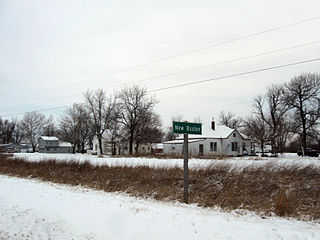
New Boston is an unincorporated community in central Lee County, Iowa, United States. It lies in the southeast corner of Iowa, along U.S. Highway 218 and southwest of the city of Fort Madison, the county seat of Lee County. New Boston is located nearby to the unincorporated communities of Argyle, Iowa and Charleston, Iowa. The community is part of the Fort Madison–Keokuk, IA-MO Micropolitan Statistical Area. There are no commercial establishments in New Boston, although this is the home of Liberty Baptist Church.

Allendorf is an unincorporated community in Osceola County, Iowa, United States. It is located on Highway 59, five miles east of Sibley, at 43.413270N, -95.64318W, adjacent to the Johnson Wilderness Area.
Bangor is an unincorporated community in Marshall County, Iowa, United States. It is located at the intersections of County Highway E18 and S62, five miles southwest of Liscomb and six miles south of Union. It is located near the west bank of the Iowa River, at 42.172838N, -93.089073W.
Adaza is an unincorporated community in Greene County, Iowa, United States. It is located on County Road E13, three miles northwest of Churdan, at 42.194705N, -94.4969273W.
Churchville is an unincorporated community in Warren County, Iowa, United States. It is located in Jefferson Township at the intersection of Churchville Street and 30th Avenue. It is 1.5 miles (2.4 km) southwest of Prole and two miles (3.2 km) north of Martensdale at an altitude of 971 feet (296 m).
Tyrone is an unincorporated community in Monroe County, Iowa, United States. Tyrone is 8.1 miles (13.0 km) west-southwest of Albia.

Downey is an unincorporated community in Cedar County, Iowa, United States.
Centerdale is an unincorporated community in Cedar County, Iowa, United States.
Plato is an unincorporated community in Cedar County, Iowa, United States. Plato is located at 41°44′17″N91°18′31″W.
Buchanan is an unincorporated community in Cedar County, Iowa, United States.
Dean is an unincorporated community in Appanoose County, Iowa, United States.
Walnut City is an unincorporated community in Appanoose County, Iowa, United States.
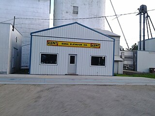
Edna is an unincorporated town in Lyon County, Iowa, United States. Edna is located on the western border of Liberal Township in Lyon County. It is located 6 miles (10 km) southeast of Rock Rapids, the county seat.
Norwood is an unincorporated community in Otter Creek Township, Lucas County, Iowa, United States. Norwood is located along U.S. Route 65, 6.2 miles (10.0 km) north of Lucas.
Thorpe is an unincorporated community in Honey Creek Township, Delaware County, Iowa, United States.

Argo is an unincorporated community and census-designated place (CDP) in Scott County, Iowa, United States. It is in the eastern part of the county, 9 miles (14 km) northeast of Bettendorf and 5 miles (8 km) northwest of Le Claire.
Abbott is an unincorporated community in Hardin County, in the U.S. state of Iowa. It is at the junction of 150th Street and V Avenue.
Alice is an unincorporated community in Linn County, in the U.S. state of Iowa.


