
The Chickasaw are an indigenous people of the Southeastern Woodlands. Their traditional territory was in the Southeastern United States of Mississippi, Alabama, and Tennessee. Their language is classified as a member of the Muskogean language family. In the present day, they are organized as the federally recognized Chickasaw Nation.

DeSoto County is a county located on the northwest border of the U.S. state of Mississippi. As of the 2010 census, the population was 161,252, making it the third-most populous county in Mississippi. Its county seat is Hernando.

Chickasaw County is a county located in the U.S. state of Mississippi. As of the 2010 census, the population was 17,392. Its county seats are Houston and Okolona. The county is named for the Chickasaw people, who lived in this area for hundreds of years. Most were forcibly removed to Indian Territory in the 1830s, but some remained and became citizens of the state and the United States.
Houston is a city in and one of two county seats of Chickasaw County, in northern Mississippi, United States. The population was 3,623 at the 2010 census.

New Houlka, also referred to simply as Houlka, is a town in Chickasaw County, Mississippi, United States. It was founded in 1904 to take advantage of a railway line of the Gulf and Ship Island Railroad. Residents moved their buildings over from the original settlement, now referred to as "Old Houlka", located to the west. The population was 626 at the 2010 census.

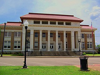
Okolona is a city in and one of the two county seats of Chickasaw County, Mississippi, United States. It is located near the eastern border of the county. The population was 2,692 at the 2010 census.

Tupelo is a city in, and the county seat of, Lee County, Mississippi, United States. With an estimated population of 38,312 in 2019, Tupelo is the sixth-largest city in Mississippi and is considered a commercial, industrial, and cultural hub of North Mississippi.
Pontotoc is a city in, and the county seat of, Pontotoc County, Mississippi, located to the west of the much larger city of Tupelo. The population was 5,625 at the 2010 census. Pontotoc is a Chickasaw word that means, “Land of the Hanging Grapes.”

Trebloc is an unincorporated community in Chickasaw County, Mississippi, United States. It is located at the intersections of Highways 8 and 47, 10.5 mi (16.9 km) southeast of Houston.

The Chickasaw Nation is a federally recognized Native American nation, with its headquarters located in Ada, Oklahoma in the United States. Currently, the nation's jurisdictional territory includes about 7,648 square miles of south-central Oklahoma, including the Bryan, Carter, Coal, Garvin, Grady, Jefferson, Johnston, Love, McClain, Marshall, Murray, Pontotoc, and Stephens counties. The Chickasaw Nation originated in its homeland of the American Southeast, with territory in what is defined as modern-day Mississippi, Tennessee, Alabama and Kentucky.
Sparta is an unincorporated community in Chickasaw County, Mississippi, United States.

The Chickasaw Bluff is the high ground rising about 50 to 200 feet (20–60 m) above the Mississippi River flood plain between Fulton in Lauderdale County, Tennessee and Memphis in Shelby County, Tennessee.

Randolph is an unincorporated rural community in Tipton County, Tennessee, United States, located on the banks of the Mississippi River. The lands of the Mississippi River Basin were inhabited by Paleo-Indians and later Native American tribes of the Mississippian culture for thousands of years. The Tipton Phase people and the Chickasaw Indian tribe populated the Mississippi River valley near Randolph during the Mississippian period. In 1541, Spanish explorer Hernando de Soto crossed the Mississippi River at or near Randolph. French explorer Cavelier de La Salle built the first French fortification at or near Randolph on his 1682 canoe expedition of the Mississippi River.
Van Vleet is an unincorporated community in Chickasaw County, Mississippi, United States. Van Vleet is located at the junction of Mississippi Highway 32 and Mississippi Highway 385, 8 miles (13 km) northeast of Houston. Van Vleet has a post office with ZIP code 38877.
Egypt, also known as Pikeville, is an unincorporated community in Chickasaw County, Mississippi, United States. Egypt is 7 miles (11 km) south of Okolona.

Old Town is a ghost town in Calhoun County, Mississippi, United States.
Mississippi Highway 47 (MS 47) is a 23.048-mile-long (37.092 km) state highway located in the U.S. state of Mississippi. The route starts at MS 50 west of West Point in Clay County. The road then travels northwest through small communities in Clay and Chickasaw counties, and it intersects MS 8 in Trebloc, Chickasaw County. MS 47 ends at Aberdeen Road near Buena Vista, and the road continues as MS 385. The route was designated around 1934, from MS 10 near West Point to MS 8 in Buena Vista, and MS 8 was rerouted south through Trebloc by 1944. MS 47 was fully paved by 1958.
Bently, also spelled Bentley, is an unincorporated community in Calhoun County, Mississippi, United States.
Thorn, also known as Flatwoods, is an unincorporated community in Chickasaw County, Mississippi, United States.
Buena Vista, also known as Monterey, is an unincorporated community in Chickasaw County, Mississippi, United States.


