Minter City is an unincorporated community in Leflore County and Tallahatchie County, Mississippi. It is part of the Greenwood, Mississippi micropolitan area, and is within the Mississippi Delta.

Plymouth was an early settlement in Mississippi in present-day Lowndes County. Plymouth was located on the west bank of the Tombigbee River at the mouth of Tibbee Creek.

Jacks Creek is an unincorporated community in Chester County, Tennessee, United States.
Baxterville is a census-designated place and unincorporated community in Lamar County, Mississippi. It is located in the southwestern portion of Lamar County along Mississippi Highway 13, southwest of Hattiesburg.

McHenry, is an unincorporated community in southern Stone County, Mississippi. It is situated approximately 10 miles (16 km) south of Wiggins and 3 miles (4.8 km) north of Saucier. The community is part of the Gulfport-Biloxi metropolitan area.

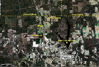
Bond is a census-designated place and unincorporated community in northern Stone County, Mississippi, United States. The community is situated approximately 3 miles (4.8 km) north of Wiggins on U.S. Route 49, and is part of the Gulfport-Biloxi metropolitan area. It was first named as a CDP in the 2020 Census which listed a population of 506.

Lancaster is an unincorporated community in Lane County, Oregon, United States. It is located about two miles south of Harrisburg and two miles north of Junction City, on Oregon Route 99E near the Willamette River.
Hub is an unincorporated community in Marion County, Mississippi, United States.
Arm is an unincorporated community in Lawrence County, Mississippi, United States. Arm is located on Mississippi Highway 43 6.4 miles (10.3 km) east-southeast of Monticello, and 2.3 miles (3.7 km) south of the junction with Mississippi Highway 43A.
Howison is an unincorporated community located in Harrison County, Mississippi. Howison is approximately 1.9 miles (3.1 km) north of Saucier and 4 miles (6.4 km) south of McHenry and part of the Gulfport-Biloxi metropolitan area.
Eutaw is a ghost town in Bolivar County, Mississippi, United States. The settlement had a port on the Mississippi River called "Eutaw Landing."
Artonish is a ghost town located in Wilkinson County, Mississippi, United States. South of the town was Artonish Landing, located on a stretch of the Mississippi River known as the "Homochitto Cutoff".
Burke Landing is an unincorporated community located on the Mississippi River in Coahoma County, Mississippi, United States.
Liverpool is a ghost town in Yazoo County, Mississippi, United States. Liverpool Landing, the settlement's port on the Yazoo River, was located 0.9 mi (1.4 km) west of Liverpool.

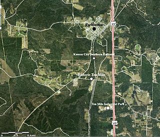
Ten Mile, also known as Tenmile, is an unincorporated community in Stone County, Mississippi, United States, located approximately 1.15 mi (1.85 km) south of Perkinston. Ten Mile is part of the Gulfport-Biloxi metropolitan area. The main period of significance was between 1904 and 1923.

Binnsville is a ghost town in Kemper County, Mississippi, United States.

Maxie is an unincorporated area in Forrest County, Mississippi. It lies within the De Soto National Forest and was a stop on the Gulf and Ship Island Railroad (G&SIRR). It had a post office from 1900 until 1967. In 1964 it had a population of 125. William Henry Bucklew, who became mayor of Laurel, Mississippi and published the Southern Baptist News, was born in Maxie. Beaverdam Creek runs through Maxie.
Merrill is an unincorporated community in George County, Mississippi, United States. Prior to the creation of George County, Merrill was located in Greene County.
Shipman is an unincorporated community in George County, Mississippi. Prior to the creation of George County, Shipman was located in Jackson County. The community was originally called Brushy, but the name was changed to Shipman in 1907. Shipman is likely named for William A. Shipman, who moved to the community from Georgia and operated a sawmill in the area.
Avera is an unincorporated community in Greene County, Mississippi. Avera was originally located along the Chickasawhay River. The community was named for Powell Avera, who settled the area prior to 1860. Around 1880, the community was moved to its present location. The former location is now known as Old Avera.


