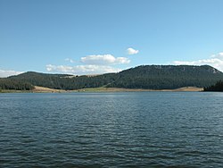
Meadow Lark Lake, Wyoming

Last updated
Meadowlark Lake, Wyoming
2003-08-16 View across Meadowlark Lake.jpg
USA Wyoming location map.svg
Red pog.svg
Meadowlark Lake, Wyoming
Location within the state of Wyoming
Usa edcp location map.svg
Red pog.svg
Meadowlark Lake, Wyoming
Meadowlark Lake, Wyoming (the United States)
Coordinates: 44°10′45″N107°13′2″W / 44.17917°N 107.21722°W / 44.17917; -107.21722 Coordinates: 44°10′45″N107°13′2″W / 44.17917°N 107.21722°W / 44.17917; -107.21722
Country United States
State Wyoming
County Big Horn
Area
  Total19.3 sq mi (50.0 km2)
  Land19.0 sq mi (49.1 km2)
  Water0.3 sq mi (0.9 km2)
Elevation
8,199 ft (2,499 m)
Population
 (2000)
  Total8
  Density0.4/sq mi (0.2/km2)
Time zone UTC-7 (Mountain (MST))
  Summer (DST) UTC-6 (MDT)
Area code(s) 307
FIPS code 56-51357 [1]
GNIS feature ID1877176 [2]

Meadowlark Lake is an unincorporated community in Big Horn County, Wyoming, United States. The population was 8 at the 2000 census, when it was a Census-designated place (CDP).

Contents

Geography

Meadowlark Lake is located at 44°10′45″N107°13′2″W / 44.17917°N 107.21722°W / 44.17917; -107.21722 (44.179299, -107.217124). [3]

According to the United States Census Bureau, in 2000 the CDP has a total area of 19.3 square miles (50.0 km2), of which, 19.0 square miles (49.1 km2) is land and 0.3 square mile (0.9 km2) (1.76%) is water.

Demographics

As of the census [1] of 2000, there were 8 people, 2 households, and 2 families residing in the CDP. The population density was 0.4 people per square mile (0.2/km2). There were 46 housing units at an average density of 2.4/sq mi (0.9/km2). The racial makeup of the CDP was 87.50% White, and 12.50% from two or more races.

There were 2 households, out of which none had children under the age of 18 living with them, 50.0% were married couples living together, and 0.0% were non-families. No households were made up of individuals, and none had someone living alone who was 65 years of age or older. The average household size was 4.00 and the average family size was 3.00.

In the CDP the population was spread out, with 62.5% from 18 to 24, 37.5% from 45 to 64, . The median age was 24 years. For every 100 females, there were 166.7 males. For every 100 females age 18 and over, there were 166.7 males.

The median income for a household in the CDP was $31,250, and the median income for a family was $31,250. Males had a median income of $0 versus $0 for females. The per capita income for the CDP was $17,167. None of the population or families were below the poverty line.

Education

Public education in the community of Meadowlark Lake is provided by Big Horn County School District #4. The district has four campuses – Laura Irwin Elementary School (grades K-4), Manderson Elementary School (grade 5), Cloud Peak Middle School (grades 6-8), and Riverside High School (grades 9-12).

Related Research Articles

Maytown, Pennsylvania Census-designated place in Pennsylvania, United States

Maytown is an unincorporated community and census-designated place (CDP) in Lancaster County, Pennsylvania, United States. The population was 3,824 at the 2010 census.

Barnes Lake-Millers Lake, Michigan Census-designated place & unincorporated community in Michigan, United States

Barnes Lake-Millers Lake is a census-designated place (CDP) and Unincorporated community within Deerfield Township, Lapeer County in the U.S. state of Michigan. The CDP is used for statistical purposes and has no legal status as a municipality. The population was 1,187 at the 2000 census.

The Lakes, Minnesota Unincorporated community in Minnesota, US

The Lakes is an unincorporated community and census-designated place (CDP) in Murray County, Minnesota, United States located just north of Currie, Minnesota. The population was 667 at the 2010 census. The community is centered about Lake Shetek, the largest lake in southwestern Minnesota. The lake and the community are located in parts of four townships in Murray County, which include Lake Sarah, Shetek, Murray, and Mason Townships.

Fort Smith, Montana Census-designated place in Montana, United States

Fort Smith is a census-designated place (CDP) in Big Horn County, Montana, United States. The population was 161 at the 2010 census. The town is named for the former Fort C.F. Smith.

Encinal, New Mexico Census-designated place in New Mexico, United States

Encinal is a census-designated place (CDP) in Cibola County, New Mexico, United States. It is the smallest of the six villages of the Laguna Pueblo and sits at the base of Mount Taylor. The population was 210 at the 2010 census. The feast day for Encinal is September 8.

Naschitti, New Mexico CDP in New Mexico, United States

Naschitti is a census-designated place (CDP) in San Juan County, New Mexico, United States. The population was 360 at the 2000 census. It is part of the Farmington Metropolitan Statistical Area. The town was established in 1886, when Tom Bryan set up a trading post east of the Chuska Mountains. With a Navajo name, Naschitti means "badger springs."

Delano, Pennsylvania CDP in Pennsylvania, United States

Delano is a census-designated place (CDP) in Schuylkill County, Pennsylvania, United States. The population was 377 at the 2000 census.

Woods Landing-Jelm, Wyoming CDP in Wyoming, United States

Woods Landing-Jelm is a census-designated place (CDP) in Albany County, Wyoming, United States. The population was 97 at the 2010 census.

Hyattville, Wyoming CDP in Wyoming, United States

Hyattville is a census-designated place (CDP) in Big Horn County, Wyoming, United States. The population was 75 at the 2010 census.

Esterbrook, Wyoming CDP in Wyoming, United States

Esterbrook is a village, and the locus of a same-named census-designated place (CDP), in Converse County, Wyoming, United States in the Medicine Bow National Forest. The population was 52 at the 2010 census.

Owl Creek, Wyoming CDP in Wyoming, United States

Owl Creek is a census-designated place (CDP) in Hot Springs County, Wyoming, United States. The population was five at the 2010 Census.

Alpine Northwest, Wyoming CDP in Wyoming, United States

Alpine Northwest is a census-designated place (CDP) in Lincoln County, Wyoming, United States. The population was 244 at the 2010 census.

Turnerville, Wyoming CDP in Wyoming, United States

Turnerville is a census-designated place (CDP) in Lincoln County, Wyoming, United States. The population was 192 at the 2010 census.

Parkman, Wyoming CDP in Wyoming, United States

Parkman is a census-designated place (CDP) in Sheridan County, Wyoming, United States. The population was 151 at the 2010 census.

Carter, Wyoming CDP in Wyoming, United States

Carter is a census-designated place (CDP) in Uinta County, Wyoming, United States. The community was named after Judge William A. Carter. The population was 10 at the 2010 census.

Lonetree, Wyoming CDP in Wyoming, United States

Lonetree is a census-designated place (CDP) in Uinta County, Wyoming, United States. The population was 49 at the 2010 census.

Airport Road, Wyoming Unincorporated community in Wyoming, United States

Airport Road is an unincorporated community in Washakie County, Wyoming, United States. The population was 297 at the 2000 census, when it was a census-designated place (CDP).

Washakie Ten, Wyoming Unincorporated community in Wyoming, United States

Washakie is an unincorporated community in Washakie County, Wyoming, United States. The population was 604 at the 2000 census, when it was a census-designated place (CDP).

West River, Wyoming Unincorporated community in Wyoming, United States

West River is an unincorporated community in Washakie County, Wyoming, United States. The population was 321 at the 2000 census, when it was a census-designated place (CDP).

Bainbridge (CDP), Ohio Census-designated place in Ohio, United States

Bainbridge is a census-designated place (CDP) in Bainbridge Township, Geauga County, Ohio, United States. As of the 2010 census, the CDP had a population of 3,267.

References

  1. 1 2 "U.S. Census website". United States Census Bureau . Retrieved 2008-01-31.
  2. "US Board on Geographic Names". United States Geological Survey. 2007-10-25. Retrieved 2008-01-31.
  3. "US Gazetteer files: 2010, 2000, and 1990". United States Census Bureau. 2011-02-12. Retrieved 2011-04-23.