Tarusa, also known as Tarussa (Тару́сса), is a town and the administrative center of Tarussky District in Kaluga Oblast, Russia, located on the left bank of the Oka River, 76 kilometers (47 mi) northeast of Kaluga, the administrative center of the oblast. Population: 9,918 (2021 Census); 9,660 (2010 Census); 9,893 (2002 Census); 8,795 (1989 Soviet census).

Kirov is a town and the administrative center of Kirovsky District in Kaluga Oblast, Russia, located on the Bolva River 160 kilometers (99 mi) southwest of Kaluga, the administrative center of the oblast. Population: 28,097 (2021 Census); 31,882 (2010 Census); 38,893 (2002 Census); 35,962 (1989 Soviet census). 29,000 (1970).

Yukhnov is a town and the administrative center of Yukhnovsky District in Kaluga Oblast, Russia, located on the Kunava River 85 kilometers (53 mi) northwest of Kaluga, the administrative center of the oblast. Population: 6,610 (2021 Census); 7,056 (2010 Census); 7,692 (2002 Census); 6,059 (1989 Soviet census).

Medyn is a town and the administrative center of Medynsky District in Kaluga Oblast, Russia, located on the Medynka River, 60 kilometers (37 mi) northwest of Kaluga, the administrative center of the oblast. Population: 8,200 (2021 Census); 8,300 (2010 Census); 7,940 (2002 Census); 8,364 (1989 Soviet census).

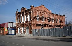
Sukhinichi is a town and the administrative center of Sukhinichsky District in Kaluga Oblast, Russia, a large railway junction on the Moscow – Kyiv line, situated on the Bryn River 105 kilometers (65 mi) southwest of Kaluga, the administrative center of the oblast. Population: 14,806 (2021 Census); 16,273 (2010 Census); 16,387 (2002 Census); 17,762 (1989 Soviet census).

Duminichsky District is an administrative and municipal district (raion), one of the twenty-four in Kaluga Oblast, Russia. It is located in the south central part of the oblast. The area of the district is 1,174 km2 (453 sq mi). Its administrative center is the urban locality of Duminichi. Population: 13,499 (2021 Census); 15,261 (2010 Census); 16,264 (2002 Census); 17,355 (1989 Soviet census). The population of Duminichi accounts for 40.6% of the district's total population.

Zhukovsky District is an administrative and municipal district (raion), one of the twenty-four in Kaluga Oblast, Russia. It is located in the northeast of the oblast. The area of the district is 1,360 square kilometers (530 sq mi). Its administrative center is the town of Zhukov. Population: 62,370 (2021 Census); 48,999 (2010 Census); 46,180 ; 45,940 (1989 Soviet census). The population of Zhukov accounts for 26.0% of the district's total population.

Iznoskovsky District is an administrative and municipal district (raion), one of the twenty-four in Kaluga Oblast, Russia. It is located in the north of the oblast. The area of the district is 1,333.8 square kilometers (515.0 sq mi). Its administrative center is the rural locality of Iznoski. Population: 6,422 (2021 Census);7,011 (2010 Census); 7,868 ; 8,502 (1989 Soviet census). The population of Iznoski accounts for 26.8% of the district's population.

Kirovsky District is an administrative and municipal district (raion), one of the twenty-four in Kaluga Oblast, Russia. It is located in the southwest part of the oblast. The area of the district is 1,000.4 square kilometers (386.3 sq mi). Its administrative center is the town of Kirov. Population: 38,364 (2021 Census); 42,105 (2010 Census); 7,118 ; 9,770 (1989 Soviet census). The population of Kirov accounts for 73.2% of the district's population.

Maloyaroslavetsky District is an administrative and municipal district (raion), one of the twenty-four in Kaluga Oblast, Russia. It is located in the northeast of the oblast. The area of the district is 1,547 square kilometers (597 sq mi). Its administrative center is the town of Maloyaroslavets. Population: 68,702 (2021 Census); 54,269 (2010 Census); 55,910 (2002 Census); 51,377 (1989 Soviet census). The population of Maloyaroslavets accounts for 60.9% of the district's total population.

Peremyshlsky District is an administrative and municipal district (raion), one of the twenty-four in Kaluga Oblast, Russia. It is located in the east of the oblast. The area of the district is 1,156 square kilometers (446 sq mi). Its administrative center is the rural locality of Peremyshl. Population: 14,422 (2021 Census); 14,137 (2010 Census); 13,952 ; 16,105 (1989 Soviet census). The population of Peremyshl accounts for 25.0% of the district's total population.

Sukhinichsky District is an administrative and municipal district (raion), one of the twenty-four in Kaluga Oblast, Russia. It is located in the center of the oblast. The area of the district is 1,232 square kilometers (476 sq mi). Its administrative center is the town of Sukhinichi. Population: 22,959 (2021 Census); 25,427 (2010 Census); 26,968 ; 31,369 (1989 Soviet census). The population of Sukhinichi accounts for 64.5% of the district's total population.

Tarussky District is an administrative and municipal district (raion), one of the twenty-four in Kaluga Oblast, Russia. It is located in the east of the oblast. The area of the district is 714.6 square kilometers (275.9 sq mi). Its administrative center is the town of Tarusa. Population: 16,603 (2021 Census); 15,255 (2010 Census); 15,680 ; 14,848 (1989 Soviet census). The population of Tarusa accounts for 59.7% of the district's total population.

Yukhnovsky District is an administrative and municipal district (raion), one of the twenty-four in Kaluga Oblast, Russia. It is located in the northwest of the oblast. The area of the district is 1,332.5 square kilometers (514.5 sq mi). Its administrative center is the town of Yukhnov. Population: 12,912 (2021 Census); 12,696 (2010 Census); 14,447 ; 13,749 (1989 Soviet census). The population of Yukhnov accounts for 51.2% of the district's total population.

Kremyonki is a town in Zhukovsky District of Kaluga Oblast, Russia. Population: 11,745 (2021 Census); 11,582 (2010 Census); 12,128 (2002 Census);
Duminichi is an urban-type settlement and the administrative center of Duminichsky District, Kaluga Oblast, Russia. Population: 5,474 (2021 Census); 6,326 (2010 Census); 7,866 (2002 Census); 7,418 (1989 Soviet census).

Polotnyany Zavod is an urban-type settlement in Dzerzhinsky District, Kaluga Oblast, Russia. Population: 4,976 (2021 Census); 5,224 (2010 Census); 5,742 (2002 Census); 5,441 (1989 Soviet census).
Seredeysky is an urban-type settlement in Sukhinichsky District, Kaluga Oblast, Russia. Population: 1,766 (2021 Census); 1,819 (2010 Census); 1,948 (2002 Census); 2,522 (1989 Soviet census).

Ulyanovo, formerly Plohino, is a rural locality and the administrative center of Ulyanovsky District, Kaluga Oblast, Russia. Population: 3,078 (2021 Census); 3,022 (2010 Census); 3,085 (2002 Census); 3,482 (1989 Soviet census).
Betlitsa is a rural locality and the administrative center of Kuybyshevsky District, Kaluga Oblast, Russia. Population: 3,959 (2021 Census); 3,589 (2010 Census); 3,868 (2002 Census); 3,911 (1989 Soviet census).