| Kaluga Oblast, Russia | |
|---|---|
| Administrative center: Kaluga | |
| As of 2013: [1] | |
| # of districts (районы) | 24 |
| # of cities/towns (города) | 19 |
| # of urban-type settlements (посёлки городского типа) | 10 |
| # of selsovets, rural okrugs, and territorial okrugs (сельсоветы, сельские округа и территориальные округа) | 277 |
| As of 2002: [2] | |
| # of rural localities (сельские населённые пункты) | 3,189 |
| # of uninhabited rural localities (сельские населённые пункты без населения) | 270 |
- Cities and towns under the oblast's jurisdiction:
- Kaluga (Калуга) (administrative center)
- city okrugs:
- Leninsky (Ленинский)
- with 3 rural okrugs under the city okrug's jurisdiction.
- Moskovsky (Московский)
- with 3 rural okrugs under the city okrug's jurisdiction.
- Oktyabrsky (Октябрьский)
- with 2 rural okrugs under the city okrug's jurisdiction.
- Leninsky (Ленинский)
- city okrugs:
- Kirov (Киров)
- Lyudinovo (Людиново)
- Obninsk (Обнинск)

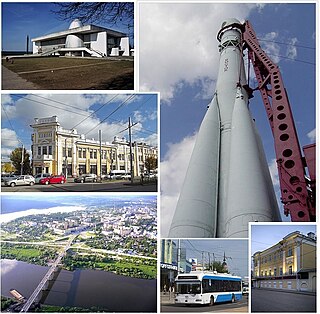
Obninsk is a city in Kaluga Oblast, Russia, located on the bank of the Protva River 100 kilometers (62 mi) southwest of Moscow and 80 kilometers (50 mi) northeast from Kaluga. Population: 104,739.
- Kaluga (Калуга) (administrative center)
- Districts:
- Babyninsky (Бабынинский)
- with 14 selsovets under the district's jurisdiction.
- Baryatinsky (Барятинский)
- with 14 selsovets under the district's jurisdiction.
- Borovsky (Боровский)
- Towns under the district's jurisdiction:
- Balabanovo (Балабаново)
- Borovsk (Боровск)
- Urban-type settlements under the district's jurisdiction:
- Yermolino (Ермолино)
- with 9 selsovets under the district's jurisdiction.
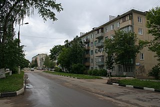
Balabanovo is a town in Borovsky District of Kaluga Oblast, Russia, located on the Protva River 76 kilometers (47 mi) northeast of Kaluga, the administrative center of the oblast. Population: 26,337 (2010 Census); 23,312 (2002 Census); 19,139 (1989 Census).

Yermolino is a town in Borovsky District of Kaluga Oblast, Russia. Population: 10,409 (2010 Census); 9,454 (2002 Census); 10,573 (1989 Census).
- Towns under the district's jurisdiction:
- Duminichsky (Думиничский)
- Urban-type settlements under the district's jurisdiction:
- Duminichi (Думиничи)
- with 13 selsovets under the district's jurisdiction.
- Urban-type settlements under the district's jurisdiction:
- Dzerzhinsky (Дзержинский)
- Towns under the district's jurisdiction:
- Kondrovo (Кондрово)
- Urban-type settlements under the district's jurisdiction:
- Kurovskoy (Куровской)
- Polotnyany Zavod (Полотняный Завод)
- Pyatovsky (Пятовский)
- Tovarkovo (Товарково)
- with 19 selsovets under the district's jurisdiction.
- Towns under the district's jurisdiction:
- Ferzikovsky (Ферзиковский)
- Urban-type settlements under the district's jurisdiction:
- Dugna (Дугна)
- with 16 selsovets under the district's jurisdiction.
- Urban-type settlements under the district's jurisdiction:
- Iznoskovsky (Износковский)
- with 10 selsovets under the district's jurisdiction.
- Khvastovichsky (Хвастовичский)
- with 17 selsovets under the district's jurisdiction.
- Kirovsky (Кировский)
- with 12 selsovets under the district's jurisdiction.
- Kozelsky (Козельский)
- Kuybyshevsky (Куйбышевский)
- with 12 selsovets under the district's jurisdiction.
- Lyudinovsky (Людиновский)
- with 10 selsovets under the district's jurisdiction.
- Maloyaroslavetsky (Малоярославецкий)
- Towns under the district's jurisdiction:
- Maloyaroslavets (Малоярославец)
- with 17 selsovets under the district's jurisdiction.
- Towns under the district's jurisdiction:
- Medynsky (Медынский)
- Towns under the district's jurisdiction:
- Medyn (Медынь)
- with 11 selsovets under the district's jurisdiction.
- Towns under the district's jurisdiction:
- Meshchovsky (Мещовский)
- Towns under the district's jurisdiction:
- Meshchovsk (Мещовск)
- with 17 selsovets under the district's jurisdiction.
- Towns under the district's jurisdiction:
- Mosalsky (Мосальский)
- Towns under the district's jurisdiction:
- Mosalsk (Мосальск)
- with 18 selsovets under the district's jurisdiction.
- Towns under the district's jurisdiction:
- Peremyshlsky (Перемышльский)
- with 16 selsovets under the district's jurisdiction.
- Spas-Demensky (Спас-Деменский)
- Towns under the district's jurisdiction:
- Spas-Demensk (Спас-Деменск)
- with 12 selsovets under the district's jurisdiction.
- Towns under the district's jurisdiction:
- Sukhinichsky (Сухиничский)
- Towns under the district's jurisdiction:
- Sukhinichi (Сухиничи)
- Urban-type settlements under the district's jurisdiction:
- Seredeysky (Середейский)
- with 17 selsovets under the district's jurisdiction.
- Towns under the district's jurisdiction:
- Tarussky (Тарусский)
- Towns under the district's jurisdiction:
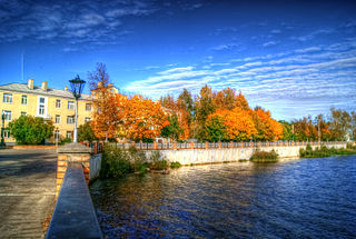
- Tarusa (Таруса)
- with 10 selsovets under the district's jurisdiction.
- Towns under the district's jurisdiction:
- Ulyanovsky (Ульяновский)
- with 5 territorial okrugs under the district's jurisdiction.
- Yukhnovsky (Юхновский)
- Towns under the district's jurisdiction:
- Yukhnov (Юхнов)
- with 13 selsovets under the district's jurisdiction.
- Towns under the district's jurisdiction:
- Zhizdrinsky (Жиздринский)
- Towns under the district's jurisdiction:
- Zhizdra (Жиздра)
- with 11 selsovets under the district's jurisdiction.
- Towns under the district's jurisdiction:
- Zhukovsky (Жуковский)

Babyninsky District is an administrative and municipal district (raion), one of the twenty-four in Kaluga Oblast, Russia. It is located in the center of the oblast. The area of the district is 845 square kilometers (326 sq mi). Its administrative center is the rural locality of Babynino. Population: 21,041 (2010 Census); 22,143 ; 16,178 (1989 Census). The population of Babynino accounts for 17.7% of the district's total population.
Baryatinsky District is an administrative and municipal district (raion), one of the twenty-four in Kaluga Oblast, Russia. It is located in the west of the oblast. The area of the district is 1,110.3 square kilometers (428.7 sq mi). Its administrative center is the rural locality of Baryatino. Population: 6,340 (2010 Census); 6,614 ; 8,097 (1989 Census). The population of Baryatino accounts for 43.3% of the district's total population.

Borovsky District is an administrative and municipal district (raion), one of the twenty-four in Kaluga Oblast, Russia. It is located in the north of the oblast. The area of the district is 759.6 square kilometers (293.3 sq mi). Its administrative center is the town of Borovsk. Population: 61,401 (2010 Census); 54,661 ; 53,698 (1989 Census). The population of Borovsk accounts for 20.0% of the district's total population.
- Babyninsky (Бабынинский)
Kaluga is a city and the administrative center of Kaluga Oblast, Russia, located on the Oka River 150 kilometers (93 mi) southwest of Moscow. Population: 324,698 (2010 Census); 334,751 (2002 Census); 311,319 (1989 Census).

Kirov is a town and the administrative center of Kirovsky District in Kaluga Oblast, Russia, located on the Bolva River 160 kilometers (99 mi) southwest of Kaluga, the administrative center of the oblast. Population: 31,882 ; 38,893 ; 35,962 (1989 Census); 29,000 (1970).
Lyudinovo is a town and the administrative center of Lyudinovsky District in Kaluga Oblast, Russia, located on the shores of Lake Lompad formed by a dam on the Nepolot River, 188 kilometers (117 mi) southwest of Kaluga, the administrative center of the oblast. As of the 2010 Census, its population was 40,530.

