
Palamas is a town and a municipality in the Karditsa regional unit, Greece. Palamas is located south-southwest of Larissa, the capital of Thessaly, northwest of Lamia, north of Sofades, east-northeast of Karditsa and east-southeast of Trikala. Palamas is linked with the road linking Karditsa and Larissa. It also serves roads with the GR-6 and Sofades. The Pineios River is to the north as well as the Trikala regional unit.
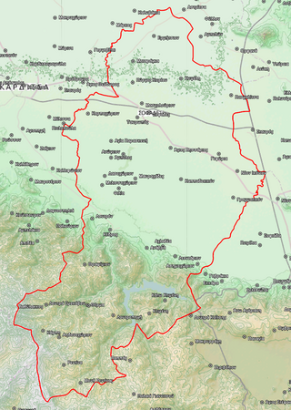
Sofades is a town and municipality in Thessaly, central Greece belonging to the regional unit of Karditsa. Its 2011 census population was 6,056 people and 18,864 for the municipality, including a large Romani community. Its elevation is around 120 m above sea level, and the economy is mainly agricultural. Sofades is located south of Palamas, southwest of Larissa, the capital of Thessaly, northwest of Lamia and southeast of Karditsa and Trikala. The native Greek inhabitants of the region are commonly known as Karagounides (Καραγκούνηδες).
Agios Dimitrios is a former municipality in the Ioannina regional unit, Epirus, Greece. Since the 2011 local government reform it is part of the municipality Dodoni, of which it is a municipal unit. Population 3,277 (2021), its area is 231.473 km². The seat of the municipality was in Theriakisi. The largest village is Kato Mousiotitsa which has a school, gymnasium and lyceum. The municipal unit covers the northwestern part of the Xerovouni mountains.

Sellana is a former municipality in the Karditsa regional unit, Thessaly, Greece, named after the ancient city of "Sellana" or "Silàna". Since the 2011 local government reform it is part of the municipality Palamas, of which it is a municipal unit. The municipal unit has an area of 89.490 km2. The seat of the municipality was in Proastio, which has 1,434 inhabitants (2021). Other communities in the municipal unit are those of Marathea, Agia Triada (548), Pedino (505) and Kalogriana (475).

Agia is a village and a municipality in the Larissa regional unit, Thessaly, Greece. Agia is located east of Larissa and south of Melivoia. The Mavrovouni mountains dominate the south and the Aegean Sea lies to the east.

Gonnoi is a former municipality in the Larissa regional unit, Thessaly, Greece. Since the 2011 local government reform it is part of the municipality Tempi, of which it is a municipal unit. The municipal unit has an area of 113.333 km2. The municipality was created under the Kapodistrias Law in 1997 out of the former communes of Gonnoi, Kallipefki, Itea and Elaia. About 2 kilometres (1.2 mi) southeast of the town lies the site of the ancient city of Gonnus, after which the present town is named.

Evrymenes is a former municipality in the Larissa regional unit, Thessaly, Greece. Since the 2011 local government reform it is part of the municipality Agia, of which it is a municipal unit. The municipal unit has an area of 95.284 km 2. The seat of the municipality was in Stomio. It was named after the ancient city Eurymenae.

Kato Olympos is a municipal unit in the Tempi municipality, within the regional unit of Larissa, in the historical and administrative region of Thessaly, Greece. Kato Olympos has, as of 2021, a population of 3,196 inhabitants. The municipal unit has an area of 128.462 km2 (49.599 sq mi). The seat of the municipal unit is located in Pyrgetos, the largest of its four 'Local Communities' :

Koilada is a village and a former municipality in the Larissa regional unit, Thessaly, Greece. Since the 2011 local government reform it is part of the municipality Larissa, of which it is a municipal unit. Population 3,256 (2021). The municipal unit has an area of 162.299 km2.
Krannonas is a village and a former municipality in the Larissa regional unit, Thessaly, Greece. Since the 2011 local government reform it is part of the municipality Kileler, of which it is a municipal unit. It is located southwest of the regional capital Larissa. In 2021 its population was 127 for the community and 2,007 for the municipal unit. The municipal unit has an area of 205.242 km2. The seat of the municipality was Agioi Anargyroi. It is located north of Farsala and NNE of Palamas and Karditsa.

Lakereia is a former municipality in the Larissa regional unit, Thessaly, Greece. It was named after the ancient city of "Lakèreia". Since the 2011 local government reform it is part of the municipality Agia, of which it is a municipal unit. Population 1,278 (2021). The seat of the municipality was in Dimitra. The municipal unit has an area of 179.386 km2.
Makrychori is a former municipality in the Larissa regional unit, Thessaly, Greece. Since the 2011 local government reform it has been part of the municipality Tempi, of which it is a municipal unit. The municipal unit has an area of 107.767 km2. The municipality was created under the Kapodistrias Law in 1997 out of the former communes of Elateia, Evangelismos, Gyrtoni and Parapotamos.

Nikaia is a town and a former municipality in the Larissa regional unit, Thessaly, Greece. Located 4 km south of Larissa city, it forms a part of Larissa's metropolitan area, that lies in the Thessalian plain. Since the 2011 local government reform it is part of the municipality Kileler, of which it is the seat and a municipal unit. Population 5,436 (2021). The municipal unit has an area of 279.562 km2.

Sarantaporo is a village and a former municipality in the Larissa regional unit, Thessaly, Greece. Since the 2011 local government reform it is part of the municipality Elassona, of which it is a municipal unit. The municipal unit has an area of 150.902 km2, and the community has an area of 26.958 km2. The town is between the mountains of Kamvounia to the northwest and the Pierian Mountains to the northeast. The river Sarantaporos flows through the municipality. Sarantaporo is on the Greek National Road 3. It is located west-southwest of Katerini, northwest of Elassona and Larissa, east of Grevena and south-southeast of Kozani.

Tyrnavos is a municipality in the Larissa regional unit, of the Thessaly region of Greece. It is the second-largest town of the Larissa regional unit, after Larissa. The town is near the mountains and the Thessalian Plain. The river Titarisios, a tributary of the Pineios, flows through the town. Tyrnavos is bypassed by the Greek National Road 3. Tyrnavos is located south-southwest of Thessaloniki and Katerini, northwest of Larissa, east-northeast of Trikala and south-southeast of Elassona and Kozani. Here live an important community of Aromanians (Vlachs).

Farkadona is a municipality in the southeastern Trikala regional unit, part of Thessaly in Greece. It is located about halfway between the cities Larissa to the east, and Trikala to the west, at about 30 km from both. It is situated in the Thessalian Plain, near the river Pineios. Farkadona is on the Greek National Road 6.
Agiokampos is a village in the municipality of Agia, in the Larissa regional unit in Greece. It has 371 inhabitants. It is a beach resort.
Sklithro is a village in Thessaly, Greece, not far from Larissa and Volos. It is part of the Melivoia municipal unit within the Agia municipality.
Sotiritsa is a village in the municipality of Agia, Larissa in the Larissa regional unit in Greece.

Skiti is a village and a community in the municipality of Agia, in the Larissa regional unit in Greece. The community includes the villages Agiokampos, Kato Polydendri and Metochia. The name of this village refers to the place that the monks lived alone away from public view. According to historic research, the ancient Melivoia was situated close to Polydendri or Skiti. The ancient Melivoia was the metropolis of Philoctetes and very popular for the deep red dying of drapery. The ancient city is placed in the south firth of the Bourboulithra stream. In the northwest of Skiti there are the ruins of a fort which most probably belonged to the Byzantine city of Kentavroupoli. About 1 kilometer Northwest of Skiti, is the monastery of mount Kelli, called Sts. Anargiroi. The monastery includes two "chambers" for the monks to leave in. The mural was created between 12th and 16th century.

