Blindheim, traditionally known in English as Blenheim, is a municipality in the Bavarian district of Dillingen in southern Germany, consisting of several villages. It is north of Augsburg, on the left bank of the Danube River. Its population is roughly 1,700.

Donauwörth is a town and the capital of the Donau-Ries district in Swabia, Bavaria, Germany. It is said to have been founded by two fishermen where the rivers Danube (Donau) and Wörnitz meet. The city is part of the scenic route called "Romantische Straße".

Neustadt an der Donau is a town in Lower Bavaria on the Danube in Bavaria, Germany. Lying on the western border of Landkreis Kelheim, Neustadt is primarily known for the thermal spa Bad Gögging. Neustadt had a population of 12,753 as of December 31, 2003.

Bogen is a town in the district of Straubing-Bogen in Bavaria, Germany. It has a population of 10,105. Bogen is located between the southern slopes of the Bavarian Forest and the River Danube. The town lies at the foot of the Bogenberg, a hill immediately on the Danube. The pilgrimage church of the Assumption of the Virgin Mary on the Bogenberg is the destination of one of the oldest pilgrimages for Saint Mary in Bavaria. This was also the seat of power of the Counts of Bogen, who died out in 1242, before the fief passed over to the Wittelsbachs. Since 1958, the German Army has been based at the Graf-Aswin-Kaserne in Bogen. The barracks are home to army engineers and are used for training medics.

Beilngries is a town in the district of Eichstätt, in Bavaria, Germany. It is situated on the river Altmühl and the Rhine-Main-Danube Canal, 30 km north of Ingolstadt.

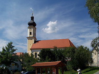
Genderkingen is a municipality in the district of Donau-Ries in Bavaria in Germany. Close to the village the river Lech flows into Danube.

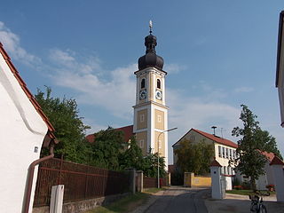
Marxheim is a municipality in the district of Donau-Ries in Bavaria in Germany. It lies on the river Danube.

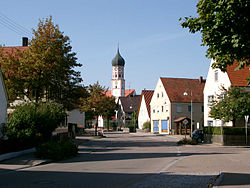
Tapfheim is a municipality in the district of Donau-Ries in Bavaria in Germany. It lies on the river Danube.

Wellheim is a municipality in the district of Eichstätt in Bavaria in Germany. It lies in the so-called "Urdonautal", the valley the Danube used some 300,000 years ago on its way to the Black Sea. Today a little river, the Schutter flows through the village in the opposite direction. The community consists of 5 villages and has about 2800 inhabitants. Today there is no industry at all but a wonderful landscape with a pure nature.

Möhrendorf is a town in the district of Erlangen-Höchstadt, in Bavaria, Germany. It lies on the river Regnitz and the Rhine-Main-Danube Canal.

Neufahrn i. NB or Neufahrn in Niederbayern is a municipality in the district of Landshut in Bavaria in Germany. Its Bavarian name is Neifing.

Bach is a municipality in the district of Regensburg in Bavaria in Germany. It lies on the Danube river.

Barbing is a municipality in the district of Regensburg in Bavaria in Germany. It lies on the Danube river.

Pentling is a municipality in the Regensburg district of Bavaria in Germany. It lies on the river Danube.

Pettendorf is a municipality in the district of Regensburg in Bavaria in Germany.
Pfatter is a municipality in the district of Regensburg in Bavaria, Germany. It lies on the river Danube. The Danube village used to be a central place in the Gäuboden and had a central function in its region.

Kirchroth is a municipality in the district of Straubing-Bogen in Bavaria, Germany. It lies on the Danube River. By the local government reform of May 1978 villages Kößnach, Oberzeitldorn, Obermiethnach, Pillnach, Pondorf, Niederachdorf, as well as Aufroth and Neuroth were incorporated.

Pfofeld is a municipality in the Weißenburg-Gunzenhausen district, in Franconia, Germany.
Irlbach is a municipality in the district of Straubing-Bogen in Bavaria, Germany. It lies on the Danube River.

Mariaposching is a municipality in the district of Straubing-Bogen in Bavaria, Germany. It is a member of the municipal association Schwarzach.