Mesoplates

Last updated

The term "mesoplates" has been applied in two different contexts within geology and geophysics. The first is applicable to much of the Earth's mantle, and the second to distinct layering within the Earth's crust.

Contents

Mantle

Rheological model

In 1977 researchers M. Kumazawa and Y. Fukao [1] introduced the term "mesoplate" in the context of what they termed a "Dual Plate Tectonic Model." Their rationale is a postulated low-velocity zone near and above the 650 km discontinuity with additional properties including local low melting temperature, active chemical migration and fractionation, and low-viscosity. They further write,

"These features lead to a concept of dual plate tectonics models. The layer between the 200- and 550-km depths is sandwiched between two relatively soft layers (upper and lower LVZs) and is expected to behave as a rigid plate (mesoplate)."

Kinematic model

From a kinematic perspective, the concept of "mesoplates" was applied as a heuristic for characterizing the motion of lithospheric plates relative to the sublithospheric source region of hotspot volcanism (Pilger, 2003), or more simply: kinematically rigid layers within the mesosphere, beneath one or more plates. [2] W. Jason Morgan (1972), originally suggested that hotspots (inferred by J. Tuzo Wilson) beneath such active volcanic regions as Hawaii and Iceland form a fixed "absolute" frame of reference for the motion of the overlying plates. However, the existence of a globally fixed reference frame for island-seamount chains and aseismic ridges ("traces") that are inferred to have originated from hotspots was quickly discounted by the primitive plate reconstructions available in the mid-1970s (Molnar and Atwater, 1973). Further, paleomagnetic measurements imply that hotspots have moved relative to the magnetic poles of the Earth (the magnetic poles are further inferred to correspond with the rotational poles of the planet when averaged over thousands of years). Aside: the term "hotspot" is used herein without any genetic implications. The term "melting spot" might well be more applicable.

Development of the kinematic concept

As plate reconstructions have improved over the succeeding three decades since Morgan's original contribution, it is become apparent that the hotspots beneath the central North and South Atlantic and Indian Oceans may form one, distinct frame of reference, while those underlying the plates beneath the Pacific Ocean form a separate reference frame. For convenience, the hotspots beneath the Pacific Ocean are referred to as the "Hawaiian set" after Hawaii, while those beneath much of the Atlantic and Indian Ocean are called the "Tristan set" after the island of Tristan da Cunha (the Tristan hotspot), one of the principal inferred hotspots of the set. Within a single hotspot set, the traces tied to their originating hotspot can be fit by plate reconstructions which imply only minor relative motion among the hotspots for perhaps the past 130 m.y. (million years) for the Tristan set and 80 m.y. for the Hawaiian set. However, the two hotspot sets are inconsistent with the hypothesis of a single hotspot reference frame; distinct motion between the two sets is apparent between 80 and 30 Ma (m.y. before Present; e.g., Raymond, et al., 2000).

It is important to acknowledge that radiometric dating of volcanism along hotspot traces may or may not accurately and precisely constrain the position of the plate above the underlying hotspot at the analytically produced age. However, reconstruction models for the Hawaiian set are constrained in age by the hotspot beneath Easter Island and its traces on the Pacific and Nazca plates between approximately 50 and 30 Ma, as the hotspot was beneath the spreading center during that time interval, and resulting relative plate reconstructions constrain motion of the plates relative to the hotspot. Prior to 50 Ma and since 30 Ma, reconstructions can be determined that fit virtually all existing Hawaiian set traces; the actual ages have the greatest uncertainty. Similarly, plate reconstructions relative to the Tristan set are best constrained in age by relative plate reconstructions, a fortuitous consequence of spherical plate tectonics of three or more plates.

Lithospheric plates are recognized in terms of their lack of internal deformation. Thus two points on the same plate will not move relative to one another, even if the plate moves relative to another plate (or relative to the Earth's rotational poles). Plates are not explicitly defined in terms of their mechanical properties. In a sense, then, "plates" are a heuristic—rather like fitting a straight line through a set of points without a clear functional relationship. Analogously, the term "mesoplate" was introduced. Since the hotspots of the Hawaiian set appear to form a frame of reference (like points on a lithospheric plate, they don't appear to be moving at a very great rate relative to one another), the hotspots and that part of the upper mantle in which they are embedded is termed the "Hawaiian mesoplate". The "Tristan mesoplate" is similarly defined. A third mesoplate, "Icelandic", is inferred to underlie the northernmost Atlantic Ocean, the Arctic Ocean, much of Eurasia to the north of the Alps and Himalayas; since the Iceland hotspot trace is not consistent with either the Hawaiian or Tristan set.

Additional evidence for mesoplates comes from observations that intraplate stresses in stable continental interiors of North America and Africa are consistent with plate motions in the Tristan hotspot frame. This observation was first made for contemporary stresses (the maximum horizontal principal compressive stress – sigma-hx); and also appears to hold for paleostress indicators between approximately 100 and 20 Ma (Pilger, 2003). This observation implies that the sublithospheric mantle over which the plates are moving comprises the same reference frame in which the hotspots are embedded.

The mesoplate heuristic is very much a hypothetical construct. Several observations could discount it. It is conceivable that a missing plate boundary between the plates beneath the Pacific and those beneath the Atlantic and Indian Oceans might be hidden and responsible for the discrepancy between the two hotspot sets. However, progressive study of the most likely region for such a boundary has failed to find it.

The origin of hotspots, whether from deep mantle plumes, mid-mantle melting anomalies, or intraplate fractures, is constrained somewhat by the mesoplate hypothesis. The principal alternative models for the origin of hotspot traces, propagating fractures, are still actively advocated by many workers (see mantleplumes.org). Such a model does not explicitly recognize sublithospheric reference frames. However, it cannot completely explain all of the features of the most familiar hotspot traces. [3]

The mantle plume hypothesis for the origin of hotspots need not be inconsistent with mesoplates. However, it would need to be modified to recognize that the lack of motion between hotspots represents a kind of "embedding" of the "plume" in the upper mantle (shallow mesosphere) of the Earth. One of Morgan's rationales for plumes was the existence of an "absolute motion" reference frame. Numerical modeling now indicates that such a reference frame would be unlikely in the context of plume convection.

If continued research were to demonstrate the continued applicability of the mesoplate hypothesis, it would have important implications for the nature of convection in the upper mantle: Convective motion beneath plates is almost entirely vertical within individual mesoplates; lateral motion in the mantle would be confined to mesoplate boundaries and to greater depths.

Crustal model

Phipps [4] coined the term "crustal mesoplate tectonics" as applied to brittle crust detached from inferred more ductile lower crust. The analogy between lithoplate tectonics and crustal deformation engaging both brittle and ductile components leads to the concept of crustal mesoplates.

Origin of the term

“Mesoplates” is a combination and contraction of two terms: “mesosphere”, as applied to the solid earth, and “tectonic plates”.

Mesosphere (solid earth)

Mesosphere” (not to be confused with mesosphere, a layer of the atmosphere) is derived from “mesospheric shell”, coined by Reginald Aldworth Daly, a Harvard University geology professor. In the pre-plate tectonics era, Daly (1940) inferred three spherical layers comprise the outer Earth: lithosphere (including the crust), asthenosphere, and mesospheric shell. Daly's hypothetical depths to the lithosphere–asthenosphere boundary ranged from 80 to 100 km and the top of the mesospheric shell (base of the asthenosphere) from 200 to 480 km. Thus, Daly's asthenosphere was inferred to be 120 to 400 km thick. According to Daly, the base of the solid earth mesosphere could extend to the base of the mantle (and, thus, to the top of the core).

Isacks, Oliver, and Sykes (1968) applied lithosphere and asthenosphere to their conception to the “New Global Tectonics” or what subsequently became known as plate tectonics. In their conception, the base of the asthenosphere extended as deep as the deepest (650–700 km) earthquakes in the inclined seismic zones where descending lithospheric plates penetrate the upper mantle.

Lithospheric (tectonic) plate (or lithoplate)

The (spherical) lithospheric plates of plate tectonics are so defined because they behave in a kinematically rigid manner. That is, any three points on the same plate do not move relative to one another, while the plate itself (and all points it contains) may move relative to other plates or other internal reference frames (e.g., the earth's spin axis or geomagnetic poles). In other words, ideal lithospheric plates do not deform internally as they move.

A “mesoplate”, then behaves like lithospheric plates: empirical evidence (discussed above) indicates groups of melting anomalies (hotspots) embedded in the shallow mesosphere do not move relative to one another, but collectively move relative to other hotspot groups and relative to overlying lithospheric plates.

See also

Related Research Articles

<span class="mw-page-title-main">Plate tectonics</span> Movement of Earths lithosphere

Plate tectonics is the scientific theory that Earth's lithosphere comprises a number of large tectonic plates, which have been slowly moving since about 3.4 billion years ago. The model builds on the concept of continental drift, an idea developed during the first decades of the 20th century. Plate tectonics came to be accepted by geoscientists after seafloor spreading was validated in the mid-to-late 1960s.

<span class="mw-page-title-main">Lithosphere</span> Outermost shell of a terrestrial-type planet or natural satellite

A lithosphere is the rigid, outermost rocky shell of a terrestrial planet or natural satellite. On Earth, it is composed of the crust and the lithospheric mantle, the topmost portion of the upper mantle that behaves elastically on time scales of up to thousands of years or more. The crust and upper mantle are distinguished on the basis of chemistry and mineralogy.

<span class="mw-page-title-main">Asthenosphere</span> Highly viscous, mechanically weak, and ductile region of Earths mantle

The asthenosphere is the mechanically weak and ductile region of the upper mantle of Earth. It lies below the lithosphere, at a depth between ~80 and 200 km below the surface, and extends as deep as 700 km (430 mi). However, the lower boundary of the asthenosphere is not well defined.

<span class="mw-page-title-main">Guyot</span> Isolated, flat-topped underwater volcano mountain

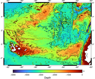
In marine geology, a guyot, also called a tablemount, is an isolated underwater volcanic mountain (seamount) with a flat top more than 200 m (660 ft) below the surface of the sea. The diameters of these flat summits can exceed 10 km (6 mi). Guyots are most commonly found in the Pacific Ocean, but they have been identified in all the oceans except the Arctic Ocean. They are analogous to tables on land.

<span class="mw-page-title-main">Convergent boundary</span> Region of active deformation between colliding tectonic plates

A convergent boundary is an area on Earth where two or more lithospheric plates collide. One plate eventually slides beneath the other, a process known as subduction. The subduction zone can be defined by a plane where many earthquakes occur, called the Wadati–Benioff zone. These collisions happen on scales of millions to tens of millions of years and can lead to volcanism, earthquakes, orogenesis, destruction of lithosphere, and deformation. Convergent boundaries occur between oceanic-oceanic lithosphere, oceanic-continental lithosphere, and continental-continental lithosphere. The geologic features related to convergent boundaries vary depending on crust types.

<span class="mw-page-title-main">Mantle plume</span> Upwelling of abnormally hot rock within Earths mantle

A mantle plume is a proposed mechanism of convection within the Earth's mantle, hypothesized to explain anomalous volcanism. Because the plume head partially melts on reaching shallow depths, a plume is often invoked as the cause of volcanic hotspots, such as Hawaii or Iceland, and large igneous provinces such as the Deccan and Siberian Traps. Some such volcanic regions lie far from tectonic plate boundaries, while others represent unusually large-volume volcanism near plate boundaries.

<span class="mw-page-title-main">African Plate</span> Tectonic plate underlying Africa

The African Plate, also known as the Nubian Plate, is a major tectonic plate that includes much of the continent of Africa and the adjacent oceanic crust to the west and south. It is bounded by the North American Plate and South American Plate to the west ; the Arabian Plate and Somali Plate to the east; the Eurasian Plate, Aegean Sea Plate and Anatolian Plate to the north; and the Antarctic Plate to the south.

<span class="mw-page-title-main">Iceland hotspot</span> Hotspot partly responsible for volcanic activity forming the Iceland Plateau and island

The Iceland hotspot is a hotspot which is partly responsible for the high volcanic activity which has formed the Iceland Plateau and the island of Iceland. It contributes to understanding the geological deformation of Iceland.

<span class="mw-page-title-main">Magmatism</span> Emplacement of magma on the outer layers of a terrestrial planet, which solidifies as igneous rocks

Magmatism is the emplacement of magma within and at the surface of the outer layers of a terrestrial planet, which solidifies as igneous rocks. It does so through magmatic activity or igneous activity, the production, intrusion and extrusion of magma or lava. Volcanism is the surface expression of magmatism.

<span class="mw-page-title-main">Galápagos hotspot</span> Pacific volcanic hotspot

The Galápagos hotspot is a volcanic hotspot in the East Pacific Ocean responsible for the creation of the Galápagos Islands as well as three major aseismic ridge systems, Carnegie, Cocos and Malpelo which are on two tectonic plates. The hotspot is located near the Equator on the Nazca Plate not far from the divergent plate boundary with the Cocos Plate. The tectonic setting of the hotspot is complicated by the Galapagos Triple Junction of the Nazca and Cocos plates with the Pacific Plate. The movement of the plates over the hotspot is determined not solely by the spreading along the ridge but also by the relative motion between the Pacific Plate and the Cocos and Nazca Plates.

<span class="mw-page-title-main">Delamination (geology)</span> Loss of the portion of the lowermost lithosphere from the tectonic plate to which it was attached

In geodynamics, delamination refers to the loss and sinking (foundering) of the portion of the lowermost lithosphere from the tectonic plate to which it was attached.

<span class="mw-page-title-main">Society hotspot</span> Pacific volcanic hotspot

The Society hotspot is a volcanic hotspot in the south Pacific Ocean which is responsible for the formation of the Society Islands, an archipelago of fourteen volcanic islands and atolls spanning around 720 kilometres (450 mi) of the ocean which formed between 4.5 and <1 Ma.

Plate reconstruction is the process of reconstructing the positions of tectonic plates relative to each other or to other reference frames, such as the Earth's magnetic field or groups of hotspots, in the geological past. This helps determine the shape and make-up of ancient supercontinents and provides a basis for paleogeographic reconstructions.

<span class="mw-page-title-main">Geology of Cape Verde</span>

Cape Verde is a volcanic archipelago situated above an oceanic rise that puts the base of the islands 2 kilometers (1.2 mi) above the rest of the seafloor. Cape Verde has been identified as a hotspot and the majority of geoscientists have argued that the archipelago is underlain by a mantle plume and that this plume is responsible for the volcanic activity and associated geothermal anomalies.

Tectonic subsidence is the sinking of the Earth's crust on a large scale, relative to crustal-scale features or the geoid. The movement of crustal plates and accommodation spaces produced by faulting brought about subsidence on a large scale in a variety of environments, including passive margins, aulacogens, fore-arc basins, foreland basins, intercontinental basins and pull-apart basins. Three mechanisms are common in the tectonic environments in which subsidence occurs: extension, cooling and loading.

<span class="mw-page-title-main">Opening of the North Atlantic Ocean</span> Breakup of Pangea

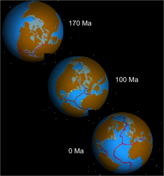
The opening of the North Atlantic Ocean is a geological event that has occurred over millions of years, during which the supercontinent Pangea broke up. As modern-day Europe and North America separated during the final breakup of Pangea in the early Cenozoic Era, they formed the North Atlantic Ocean. Geologists believe the breakup occurred either due to primary processes of the Iceland plume or secondary processes of lithospheric extension from plate tectonics.

<span class="mw-page-title-main">Lower mantle</span> The region from 660 to 2900 km below Earths surface

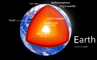
The lower mantle, historically also known as the mesosphere, represents approximately 56% of Earth's total volume, and is the region from 660 to 2900 km below Earth's surface; between the transition zone and the outer core. The preliminary reference Earth model (PREM) separates the lower mantle into three sections, the uppermost (660–770 km), mid-lower mantle (770–2700 km), and the D layer (2700–2900 km). Pressure and temperature in the lower mantle range from 24–127 GPa and 1900–2600 K. It has been proposed that the composition of the lower mantle is pyrolitic, containing three major phases of bridgmanite, ferropericlase, and calcium-silicate perovskite. The high pressure in the lower mantle has been shown to induce a spin transition of iron-bearing bridgmanite and ferropericlase, which may affect both mantle plume dynamics and lower mantle chemistry.

Ridge push is a proposed driving force for plate motion in plate tectonics that occurs at mid-ocean ridges as the result of the rigid lithosphere sliding down the hot, raised asthenosphere below mid-ocean ridges. Although it is called ridge push, the term is somewhat misleading; it is actually a body force that acts throughout an ocean plate, not just at the ridge, as a result of gravitational pull. The name comes from earlier models of plate tectonics in which ridge push was primarily ascribed to upwelling magma at mid-ocean ridges pushing or wedging the plates apart.

<span class="mw-page-title-main">Plate theory (volcanism)</span> Model of volcanic activities on Earth

The plate theory is a model of volcanism that attributes all volcanic activity on Earth, even that which appears superficially to be anomalous, to the operation of plate tectonics. According to the plate theory, the principal cause of volcanism is extension of the lithosphere. Extension of the lithosphere is a function of the lithospheric stress field. The global distribution of volcanic activity at a given time reflects the contemporaneous lithospheric stress field, and changes in the spatial and temporal distribution of volcanoes reflect changes in the stress field. The main factors governing the evolution of the stress field are:

  1. Changes in the configuration of plate boundaries.
  2. Vertical motions.
  3. Thermal contraction.

Intraplate volcanism is volcanism that takes place away from the margins of tectonic plates. Most volcanic activity takes place on plate margins, and there is broad consensus among geologists that this activity is explained well by the theory of plate tectonics. However, the origins of volcanic activity within plates remains controversial.

References

  1. Kumazawa, M.; Fukao, Y. (1977). "Dual Plate Tectonics Model". High-Pressure Research. p. 127. doi:10.1016/B978-0-12-468750-9.50014-0. ISBN   978-0-12-468750-9.
  2. Pilger, Rex H. (2003). "Hotspot Reference Frames: The 'Necessity' of Mesoplates". Geokinematics. pp. 201–211. doi:10.1007/978-3-662-07439-8_11. ISBN   978-3-642-05608-6.
  3. Pilger, R. H. (March 2007). "The Bend: Origin and significance". Geological Society of America Bulletin. 119 (3–4): 302–313. Bibcode:2007GSAB..119..302P. doi:10.1130/B25713.1.
  4. Phipps, S. P. (1992). "Crustal Mesoplate Tectonics: Deformation in Continental Interiors by Basement Detachment". Basement Tectonics 7. Proceedings of the International Conferences on Basement Tectonics. Vol. 1. p. 479. doi:10.1007/978-94-017-0833-3_38. ISBN   978-90-481-4117-3.

Further reading