Microregion of Assis | |
---|---|
Microregion | |
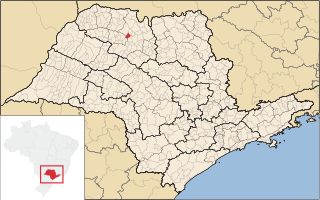
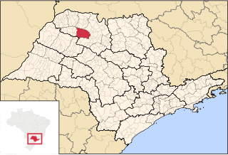
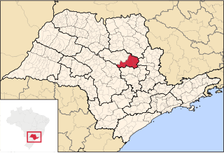
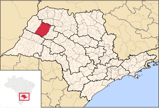
Location of the Microregion of Assis | |
Country | |
Region | Southeast |
State | |
Mesoregion | Assis |
Area | |
• Total | 7,141.738 km2 (2,757.440 sq mi) |
Population (2014/IBGE) | |
• Total | 278.220 |
• Density | 0.039/km2 (0.10/sq mi) |
Estimative | |
Time zone | UTC-3 (UTC-3) |
• Summer (DST) | UTC-2 (UTC-2) |
Area code(s) | +55 18 |
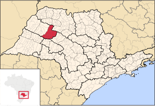
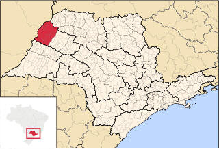
The Microregion of Assis (Portuguese : Microrregião de Assis) is located on the west of São Paulo state, Brazil, and is made up of 17 municipalities and it belongs to the Mesoregion of Assis.
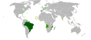
Portuguese is a Western Romance language originating in the Iberian Peninsula. It is the sole official language of Portugal, Brazil, Cape Verde, Guinea-Bissau, Mozambique, Angola, and São Tomé and Príncipe. It also has co-official language status in East Timor, Equatorial Guinea and Macau in China. As the result of expansion during colonial times, a cultural presence of Portuguese and Portuguese creole speakers are also found in Goa, Daman and Diu in India; in Batticaloa on the east coast of Sri Lanka; in the Indonesian island of Flores; in the Malacca state of Malaysia; and the ABC islands in the Caribbean where Papiamento is spoken, while Cape Verdean Creole is the most widely spoken Portuguese-based Creole. Reintegrationists maintain that Galician is not a separate language, but a dialect of Portuguese. A Portuguese-speaking person or nation is referred to as "Lusophone" (Lusófono).
São Paulo is one of the 26 states of the Federative Republic of Brazil and is named after Saint Paul of Tarsus. As the richest Brazilian state and a major industrial complex, often dubbed the "locomotive of Brazil", the state is responsible for 33.9% of the Brazilian GDP. São Paulo also has the second highest Human Development Index (HDI) and GDP per capita, the fourth lowest infant mortality rate, the third highest life expectancy, and the third lowest rate of illiteracy among the federative units of Brazil, being by far, the safest state in the country. The homicide rate is 3.8 per 100 thousand as of 2018, almost 1/4 of the Brazilian rate. São Paulo alone is richer than Argentina, Uruguay, Paraguay and Bolivia combined. If São Paulo were an independent country, its nominal GDP would be ranked among the top 20 in the world. The economy of São Paulo State is the most developed in Brazil.
Brazil, officially the Federative Republic of Brazil, is the largest country in both South America and Latin America. At 8.5 million square kilometers and with over 208 million people, Brazil is the world's fifth-largest country by area and the fifth most populous. Its capital is Brasília, and its most populated city is São Paulo. The federation is composed of the union of the 26 states, the Federal District, and the 5,570 municipalities. It is the largest country to have Portuguese as an official language and the only one in the Americas; it is also one of the most multicultural and ethnically diverse nations, due to over a century of mass immigration from around the world.
The population of the Microregion is 278.220 inhabitants, in an area of 7.141,738 km² [1]
The microregion consists of the following municipalities, [2] listed below with their 2014 Census populations (IBGE/2014): [3]
The Brazilian Institute of Geography and Statistics or IBGE is the agency responsible for official collection of statistical, geographic, cartographic, geodetic and environmental information in Brazil. IBGE performs a decennial national census; questionnaires account for information such as age, household income, literacy, education, occupation and hygiene levels.
Assis is a city and a municipality in the southwestern part of the state of São Paulo in Brazil. The population is 103,666 in an area of 460.61 km². The town was founded on July 5, 1905 and became a municipality in 1917, when it was separated from Platina. It is the largest city of its microregion, and the 2nd of its mesoregion, and is 434 km away from the capital, São Paulo. The town has an annual average temperature of 21,37 °C, annual rainfall 1,441 mm (56.7 in), and the vegetation predominates Mata Atlântica and Cerrado, is then a transition zone of vegetation. Its Human Development Index (HDI) is 0.805, considered high if comparated to state and is in 28th place among Brazilian cities.
Paraguaçu Paulista is a municipality in south-west of the state of São Paulo in Brazil. It is part of the Microregion of Assis, situated in the middle Paranapanema Valley. The population is 44,794 in an area of 1001.3 km². It's the second largest population of microregion and the 3rd of mesoregion, and is 422 km away from the capital, São Paulo. Paraguaçu was created as a district of the (then) municipality of Conceição de Monte Alegre in 1923. It became a separate municipality in 1925. Its name was changed to Paraguaçu Paulista in 1948.
Cândido Mota is a municipality in the state of São Paulo in Brazil. The population is 31,131 in an area of 596 km². The elevation is 479 m.
Bálsamo is a municipality in the state of São Paulo, Brazil. The population is 8,773 in an area of 149.9 km². The municipality belongs to the Mesoregion and Microregion of São José do Rio Preto.
Fernandópolis is a municipality in the state of São Paulo, Brazil. The population is 68,670(2017 est.) in an area of 554;km². Fernandópolis is the center of the microregion of Fernandópolis with 104,623 inhabitants and area of 2,811.7 km².
José Bonifácio is a municipality in the state of São Paulo, Brazil. The population is of 32,763 inhabitants and the area is 859.94 km². The city belongs to the Microregion of São José do Rio Preto.
Nova Granada is a municipality in the northern part of the state of São Paulo, Brazil. The population is 19,180 inhabitants (IBGE/2010), and the area is 533.49 km². The elevation is 542 m.
Olímpia is a municipality in the northern part of the state of São Paulo, Brazil. The population, measured in 2010 by the IBGE, is 50,024 inhabitants. The city has an area of 802.6 km2 (309.9 sq mi).
The Microregion of São José do Rio Preto is located on the north of São Paulo state, Brazil, and is made up of 29 municipalities. It belongs to the Mesoregion of São José do Rio Preto.
The Microregion of Votuporanga is located on the northwest of São Paulo state, Brazil, and is made up of 9 municipalities. It belongs to the Mesoregion of São José do Rio Preto.
The Microregion of Novo Horizonte is located on the north of São Paulo state, Brazil, and is made up of 6 municipalities. It belongs to the Mesoregion of São José do Rio Preto.
The Microregion of Catanduva is located on the north of São Paulo state, Brazil, and is made up of 13 municipalities. It belongs to the Mesoregion of São José do Rio Preto.
The Microregion of Auriflama is located on the northwest of São Paulo state, Brazil, and is made up of 9 municipalities. It belongs to the Mesoregion of São José do Rio Preto.
The Microregion of Jales is located on the northwest of São Paulo state, Brazil, and is made up of 23 municipalities. It belongs to the Mesoregion of São José do Rio Preto.
The Microregion of Fernandópolis is located on the northwest of São Paulo state, Brazil, and is made up of 13 municipalities. It belongs to the Mesoregion of São José do Rio Preto.
The Microregion of Nhandeara is located on the northwest of São Paulo state, Brazil, and is made up of 9 municipalities. It belongs to the Mesoregion of São José do Rio Preto.
The Microregion of São Carlos is located on the east-center of São Paulo state, Brazil, and is made up of 6 municipalities. It belongs to the Mesoregion of Araraquara.
The Microregion of Araçatuba is located on the northwest of São Paulo state, Brazil, and is made up of 7 municipalities. It belongs to the Mesoregion of Araçatuba.
The Microregion of Birigüi is located on the northwest of São Paulo state, Brazil, and is made up of 18 municipalities. It belongs to the Mesoregion of Araçatuba.
The Microregion of Andradina is located on the northwest of São Paulo state, Brazil, and is made up of 11 municipalities. It belongs to the Mesoregion of Araçatuba.
The Mesoregion of Assis is one of the 15 mesoregions of the São Paulo state, Brazil. It is located at the southwest portion of the state, and has an area of 12,710.210 km² and the seat of mesoregion is in Assis.
Coordinates: 22°39′43″S50°24′43″W / 22.6619°S 50.4119°W
A geographic coordinate system is a coordinate system that enables every location on Earth to be specified by a set of numbers, letters or symbols. The coordinates are often chosen such that one of the numbers represents a vertical position and two or three of the numbers represent a horizontal position; alternatively, a geographic position may be expressed in a combined three-dimensional Cartesian vector. A common choice of coordinates is latitude, longitude and elevation. To specify a location on a plane requires a map projection.
This geographical article relating to the state of São Paulo is a stub. You can help Wikipedia by expanding it. |