Microregion of Sorocaba

Last updated
Microregion of
Sorocaba
Microregion
SaoPaulo Micro Sorocaba.svg
Location of Microregion of Sorocaba in the state of São Paulo
Country Flag of Brazil.svg  Brazil
Region Southeast
State Bandeira do Estado de Sao Paulo.svg  São Paulo
Mesoregion Macro Metropolitan Paulista
Area
  Total 4,202 km2 (1,622 sq mi)
Time zone UTC-3 (UTC-3)
  Summer (DST) UTC-2 (UTC-2)

The Microregion of Sorocaba (Portuguese : Microrregião de Sorocaba) is a microregion in the central part of São Paulo State, Brazil.

Portuguese language Romance language that originated in Portugal

Portuguese is a Western Romance language originating in the Iberian Peninsula. It is the sole official language of Portugal, Brazil, Cape Verde, Guinea-Bissau, Mozambique, Angola, and São Tomé and Príncipe. It also has co-official language status in East Timor, Equatorial Guinea and Macau in China. As the result of expansion during colonial times, a cultural presence of Portuguese and Portuguese creole speakers are also found in Goa, Daman and Diu in India; in Batticaloa on the east coast of Sri Lanka; in the Indonesian island of Flores; in the Malacca state of Malaysia; and the ABC islands in the Caribbean where Papiamento is spoken, while Cape Verdean Creole is the most widely spoken Portuguese-based Creole. Reintegrationists maintain that Galician is not a separate language, but a dialect of Portuguese. A Portuguese-speaking person or nation is referred to as "Lusophone" (Lusófono).

Brazil Federal republic in South America

Brazil, officially the Federative Republic of Brazil, is the largest country in both South America and Latin America. At 8.5 million square kilometers and with over 208 million people, Brazil is the world's fifth-largest country by area and the fifth most populous. Its capital is Brasília, and its most populated city is São Paulo. The federation is composed of the union of the 26 states, the Federal District, and the 5,570 municipalities. It is the largest country to have Portuguese as an official language and the only one in the Americas; it is also one of the most multicultural and ethnically diverse nations, due to over a century of mass immigration from around the world.

Contents

Municipalities

The microregion consists of the following municipalities: [1]

Alumínio Municipality in Southeast, Brazil

Alumínio is a Brazilian municipality of the state of São Paulo. It is part of the Metropolitan Region of Sorocaba. The population is 18,061 in an area of 83.66 km². The elevation is 790 m. Alumínio is located east of Sorocaba and is also a suburban area. The main employer in Alumínio is Companhia Brasileira de Aluminio.

Araçariguama Municipality in Southeast, Brazil

Araçariguama is a city on the state of São Paulo in Brazil. It is part of the Metropolitan Region of Sorocaba. The population of city is of 20,114 in an area of 145.20 km². The elevation is 695 m. Araçariguama was established in 1653.

Araçoiaba da Serra Municipality in Southeast Brazil, Brazil

Araçoiaba da Serra is a city in the state of São Paulo in Brazil. It is part of the Metropolitan Region of Sorocaba. The population is 31,321 in an area of 255.33 km². The elevation is 625 m. The name Araçoiaba comes from the Tupi language, meaning "hider of the sun". This name comes from a single mountain nearby that the natives noted hid the sun as it set in the area.

Economy

Many people travel to São Paulo to work during the week, particularly from the larger of the municipalities. Those who work in São Paulo can usually afford larger houses due to the lower cost of living outside of São Paulo. In the smaller towns such as Votorantim there is a lot of agricultural employment.

Related Research Articles

Sorocaba Municipality in Southeast Brazil, Brazil

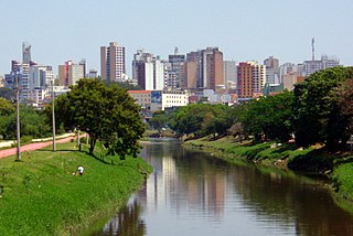
Sorocaba is a municipality in the state of São Paulo, Brazil. Sorocaba is the eighth-largest city in the state of São Paulo. Outside the Greater São Paulo region, it ranks behind only Campinas, São José dos Campos and Ribeirão Preto. It is part of the Metropolitan Region of Sorocaba. The population is 644,919 in an area of 450.38 km2.

Cesário Lange Municipality in Southeast Brazil, Brazil

Cesário Lange is a Brazilian municipality in the state of São Paulo. It is part of the Metropolitan Region of Sorocaba, and the statistical mesoregion of Itapetininga and microregion Tatuí. The population is 17,163 in an area of 190.39 km².

Piedade, São Paulo Municipality in Southeast Brazil, Brazil

Piedade is a municipality in the state of São Paulo in Brazil. It is part of the Metropolitan Region of Sorocaba. The population is 54,717 in an area of 746.87 km². The elevation is 781 m.

Votorantim Municipality in Southeast

Votorantim is a city located at the southwest of São Paulo State in Brazil. It is part of the Metropolitan Region of Sorocaba. The population is 117,794. The city is located about 100 km (62 mi) away from the capital of the state. It has 147 km2 (57 sq mi) of rural area, 30 km2 (12 sq mi) of urban area and a total area of 183.52 km2 (70.86 sq mi).

Greater São Paulo large metropolitan area located in the São Paulo state in Brazil

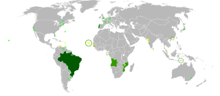
The Greater São Paulo is a nonspecific term for one of the multiple definitions the large metropolitan area located in the São Paulo state in Brazil.

Rodovia José Magalhães Teixeira

The Rodovia José Magalhães Teixeira is the Campinas Beltway, a ring of high-speed highways surrounding the city of Campinas, in the state of São Paulo, Brazil. The Campinas Beltway is the Northern vertex of the Macrometropolitan Highway System of Greater São Paulo and one of the few complete metropolitan beltways in the country. It is an extensive structure, which directly interconnects 6 large double-lane highways to all quadrants of the state. Furthermore, it is superdimensioned, i.e., it has enough capacity to accommodate huge traffic loads without getting congested, even in peak hours.

Salto, São Paulo Municipality in Southeast Brazil, Brazil

Salto is a municipality in the state of São Paulo in Brazil. It is part of the Metropolitan Region of Sorocaba. The population is 114,171 in an area of 133.06 km². The elevation is 555 m. The city has one main river, rio Tietê. The city has an important geological park: "Moutonée Park".

Salto de Pirapora Municipality in Southeast Brazil, Brazil

Salto de Pirapora is a municipality in the state of São Paulo in Brazil. It is part of the Metropolitan Region of Sorocaba. The population is 43,574 in an area of 280.70 km2 (108.38 sq mi). The elevation is 630 m (2,070 ft).

Tietê, São Paulo Municipality in Southeast Brazil, Brazil

Tietê is a Brazilian municipality in the state of São Paulo, located in the Metropolitan Region of Sorocaba, in the Meso-region of Piracicaba and in the Microregion of Piracicaba. It is located at latitude 23º06'07 "south and at a longitude 47º42'53" west, being at an altitude of 508 meters. Its estimated population in 2009 was 36 211 inhabitants. It has an area of 392,509 km2. This corresponds to a population density of 86.6 inhabitants/km2.

Rodovia Sen. José Ermírio de Moraes highway in São Paulo

The Rodovia Senador José Ermírio de Moraes or SP-75 is a highway in the southeastern part of the state of São Paulo in Brazil. It begins in Sorocaba and ends at the SP-308 near Salto. It is also nicknamed Castelinho due to its similarity with Rodovia Castelo Branco.

The SP-79 is a highway in the southeastern part of the state of São Paulo in Brazil.

Sorocaba River river in Brazil

The Sorocaba River is a river of São Paulo state in southeastern Brazil. It is a tributary of the Tietê River. The river runs large and important part of the municipality of Sorocaba.

Subprefecture of Santo Amaro Subprefecture in Southeast, Brazil

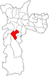
The Subprefecture of Santo Amaro is one of 32 subprefectures of the city of São Paulo, Brazil. It comprises three districts: Santo Amaro, Campo Belo, and Campo Grande.

Palmeiras-Barra Funda Intermodal Terminal

Palmeiras-Barra Funda Intermodal Terminal is the second largest intermodal transportation hub in São Paulo, Brazil. The terminal has access to the São Paulo Metro, CPTM commuter rail, and numerous bus lines.

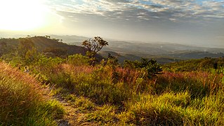
The São Francisco Ridge is a topographic elevation in the Brazilian Highlands, situated in the south of the cities of Votorantim and Sorocaba, state of São Paulo, Brazil.

Cruzeiro do Sul is the largest newspaper in Sorocaba city, São Paulo, Brazil. It was founded on June 12, 1903, by brothers Firmino Joaquim Pires de Camargo and João Clímaco Pires de Camargo. The publication began distributing the same year, initially four pages, with a bi-weekly circulation. It is owned and sponsored by the Ubaldino do Amaral Foundation-FUA.

Microregion of Seridó Ocidental Microregion in Rio Grande do Norte, Brazil

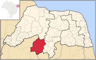
Seridó Ocidental is a microregion in the Brazilian state of Rio Grande do Norte.

São Paulo Macrometropolis human settlement in Brazil

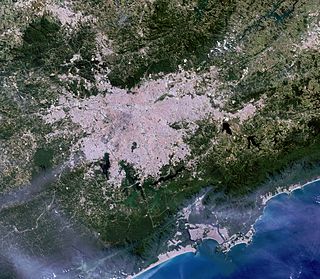
The São Paulo Macrometropolis, also known as Expanded Metropolitan Complex is a Brazilian megalopolis that emerged through the existing process of conurbation between the São Paulo's metropolitan areas located around the Greater São Paulo, with more than 30 million inhabitants, or 74 percent of São Paulo State's population, is one of the most populous urban agglomerations in the world.

The Metropolitan Region of Sorocaba is an administrative division of the state of São Paulo in Brazil. It was created in 2014, and consists of the following municipalities:

References

Coordinates: 23°30′07″S47°27′28″W / 23.50194°S 47.45778°W / -23.50194; -47.45778

Geographic coordinate system Coordinate system

A geographic coordinate system is a coordinate system that enables every location on Earth to be specified by a set of numbers, letters or symbols. The coordinates are often chosen such that one of the numbers represents a vertical position and two or three of the numbers represent a horizontal position; alternatively, a geographic position may be expressed in a combined three-dimensional Cartesian vector. A common choice of coordinates is latitude, longitude and elevation. To specify a location on a plane requires a map projection.