![Turks and Caicos Islands dependent country in West Indies]]](https://upload.wikimedia.org/wikipedia/commons/thumb/a/a0/Flag_of_the_Turks_and_Caicos_Islands.svg/320px-Flag_of_the_Turks_and_Caicos_Islands.svg.png)
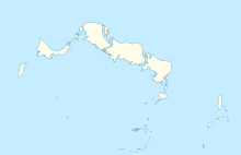
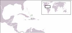
The Turks and Caicos Islands are a British Overseas Territory consisting of the larger Caicos Islands and smaller Turks Islands, two groups of tropical islands in the Lucayan Archipelago of the Atlantic Ocean and northern West Indies. They are known primarily for tourism and as an offshore financial centre. The resident population is 31,458 as of 2012 of whom 23,769 live on Providenciales in the Caicos Islands. It is the third largest of the British overseas territories by population.
Grand Turk Island is an island in the Turks and Caicos Islands. It is the largest island in the Turks Islands with 18 km2 (6.9 sq mi). Grand Turk contains the territory's capital, Cockburn Town and the JAGS McCartney International Airport. The island is the administrative, historic, cultural and financial center of the territory, and has the second largest population of the islands at approximately 3,720 people.
The majority of the population of the Turks and Caicos Islands are Christian. The Religious groups were; Protestant, 72.8% (Baptists 35.8%, Church of God 11.7%, Roman Catholics11.4%, Anglicans 10%, Methodists 9.3%, Seventh-Day Adventists 6%, Jehovah's Witnesses 1.8% and Other 14%

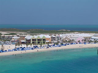
Providenciales is an island in the northwest Caicos Islands, part of the Turks and Caicos Islands, a British Overseas Territory. The island has an area of 98 km2 (38 sq mi) and a 2012 Census population of 23,769. Providenciales is the largest island in population, the third largest in area, and is home to a large majority of the population of the Turks and Caicos Islands. Providenciales was ranked the best beach destination in the world by TripAdvisor in 2011.

Providenciales International Airport, on the island of Providenciales in the Caicos Islands, is the main international airport serving the Turks and Caicos Islands, a British Overseas Territory of the United Kingdom. It is operated by Turks and Caicos Islands Airports Authority (TCIAA). The territory's other international airport is JAGS McCartney International Airport on Grand Turk Island. Currently, there are more than 12,000 commercial aircraft operations per year.

North Caicos is the second-largest island in the Turks and Caicos Islands. To the west, the Caicos Cays link to Providenciales. To the east, it is separated from Middle Caicos by Juniper Hole, a narrow passage that can accommodate only small boats. A 1-mile causeway connects North Caicos to Middle Caicos.

JAGS McCartney International Airport, also known as Grand Turk International Airport, is an airport located one mile south of Cockburn Town on Grand Turk Island in the Turks and Caicos Islands, an overseas territory of the United Kingdom. It is the second largest airport in the Turks & Caicos, after Providenciales International Airport.

Middle Caicos, also Grand Caicos, is the largest island in the Turks and Caicos Islands. To the west, it is separated from North Caicos by Juniper Hole, and to the east, from East Caicos by Lorimer Creek, both narrow passages that can accommodate only small boats. The island is known for its extensive system of caves and its significant Lucayan Indian archeological sites. The island is connected to North Caicos via a causeway.

Global Airways is an Air Charter airline based at the Providenciales International Airport which is the main airport of the Turks and Caicos Islands.

Ambergris Cay, also known as Big Ambergris Cay, is a private residential island located within the Turks and Caicos Islands. Not to be confused with Ambergris Caye in Belize, Ambergris Cay is situated to the southeast of the main chain of the Caicos islands. Adjacent to Ambergris Cay is Little Ambergris Cay, which is an uninhabited natural reserve. Little Ambergris Cay is a unique and significant habitat for a wide range of birds and marine life. Ambergris Cay island is approximately four miles long, one mile wide, and 1,100 acres (4.5 km2) in total.
The following outline is provided as an overview of and topical guide to the Turks and Caicos Islands:
The following is an alphabetical list of topics related to the British Overseas Territory of the Turks and Caicos Islands.

North Caicos Airport is an airport serving North Caicos, the second largest of the Turks and Caicos Islands.
Salt Cay Airport is the public airport serving Salt Cay, the second largest of the Turks Islands in the Turks and Caicos Islands. It closed on 26 June 2017 because of safety concerns with the runway and other infrastructure.
South Caicos Airport is an airport serving South Caicos, the seventh largest of the Turks and Caicos Islands.

Madison Municipal Airport is a city-owned public use airport located one nautical mile northeast of the central business district of Madison, a city in Lake County, South Dakota, United States. This airport is included in the FAA's National Plan of Integrated Airport Systems for 2009–2013, which categorized it as a general aviation facility.
Snwazna Adams is a beauty pageant titleholder who was crowned Miss Universe Turks and Caicos 2013 and represented the Turks & Caicos at the Miss Universe 2013 Pageant.
The Royal Turks and Caicos Islands Police Force is the national police force of the Turks and Caicos Islands, a British Overseas Territory. It is one of the oldest police forces in the world.