This list of airports in the United Kingdom is a partial list of public active aerodromes (airports and airfields) in the UK and the British Crown Dependencies. Most private airfields are not listed. For a list ranked by volume of traffic, see Busiest airports in the United Kingdom by total passenger traffic.
The ICAO codes for airports in the United Kingdom (and its Crown Dependencies) begin with the two letters "EG". RAF Mount Pleasant on the Falkland Islands also uses the "EG" code.
Airport names in italics are listed in the UK Aeronautical Information Publication. [1] Airport names in bold have scheduled commercial airline service(s). Runway information is for the longest runway when more than one is available.
Location | County | ICAO | IATA | Airport name | Usage | Rwy Length | Surface | Elevation (m) | |
---|---|---|---|---|---|---|---|---|---|
(m) | (ft) | ||||||||
Aldergrove | County Antrim | EGAA | BFS | Belfast International Airport | Public | 2,780 | 9,121 | Asphalt | 82 |
Belfast | County Down | EGAC | BHD | George Best Belfast City Airport | Public | 1,829 | 6,001 | Asphalt | 5 |
Eglinton | County Londonderry | EGAE | LDY | City of Derry Airport | Public | 1,967 | 6,453 | Asphalt | 7 |
Enniskillen | County Fermanagh | EGAB | ENK | Enniskillen/St Angelo Airport | Private | 1,326 | 4,350 | Asphalt | 47 |
Newtownards | County Down | EGAD | Newtownards Airport | Public | 794 | 2,605 | Asphalt | 3 |
Location | County | ICAO | IATA | Airport name | Usage | Rwy Length | Surface | Elevation (m) | |
---|---|---|---|---|---|---|---|---|---|
(m) | (ft) | ||||||||
Aberdeen | Aberdeen | EGPD | ABZ | Aberdeen Airport | Public | 1,953 | 6,407 | Asphalt | 66 |
Ardchattan and Muckairn | Argyll and Bute | EGEO | OBN | Oban Airport | Public | 1,240 | 4,068 | Asphalt | 7 |
Baltasound | Shetland | EGPW | UNT | Unst Airport | Public | 640 | 2,100 | Asphalt | |
Benbecula | Na h-Eileanan Siar | EGPL | BEB | Benbecula Airport | Public | 1,836 | 6,023 | Asphalt | 6 |
Barra | Na h-Eileanan Siar | EGPR | BRR | Barra Airport | Public | 846 | 2,776 | Sand | 2 |
Campbeltown | Argyll and Bute | EGEC | CAL | Campbeltown Airport (RAF Machrihanish ) | Public | 3,049 | 10,003 | Asphalt | 13 |
Coll | Argyll and Bute | EGEL | COL | Coll Airport | Public | 500 | 1,640 | Asphalt | 6 |
Colonsay and Oronsay | Argyll and Bute | EGEY | CSA | Colonsay Airport | Public | 501 | 1,644 | Asphalt | 13 |
North Ronaldsay | Orkney | EGEN | NRL | North Ronaldsay Airport | Public | 467 | 1,532 | Graded hardcore | 17 |
Cumbernauld | North Lanarkshire | EGPG | Cumbernauld Airport | Public | 820 | 2,690 | Asphalt | 107 | |
Dalcross | Highland | EGPE | INV | Inverness Airport | Public | 1,887 | 6,191 | Asphalt | 9 |
Dundee | Dundee | EGPN | DND | Dundee Airport | Public | 1,400 | 4,593 | Asphalt | 5 |
Dunrossness | Shetland | EGPB | LSI | Sumburgh Airport | Public | 1,426 | 4,678 | Asphalt | 6 |
Eday | Orkney | EGED | EOI | Eday Airport | Public | 467 | 1,532 | Graded hardcore | 6 |
Edinburgh | Edinburgh | EGPH | EDI | Edinburgh Airport | Public | 2,560 | 8,399 | Asphalt | 41 |
Fair Isle | Shetland | EGEF | FIE | Fair Isle Airport | Private | 486 | 1,594 | Gravel | 68 |
Foula | Shetland | FOA | Foula Airfield | 457 | 1,500 | Gravel | |||
Islay | Argyll and Bute | EGPI | ILY | Islay Airport | Public | 1,545 | 5,068 | Asphalt | 17 |
Kinglassie | Fife | EGPJ | Fife Airport | Public | 700 | 2,297 | Asphalt | ||
Kinloss | Moray | EGQK | FSS | Kinloss Barracks | Military | 2,311 | 7,582 | Asphalt | |
Sanday | Orkney | EGES | NDY | Sanday Airport | Public | 467 | 1,532 | Graded hardcore | 20 |
Leuchars | Fife | EGQL | ADX | Leuchars Station | Military | 2,588 | 8,491 | Asphalt | |
Lossiemouth | Moray | EGQS | LMO | RAF Lossiemouth | Military | 2,749 | 9,019 | Asphalt | |
Out Skerries | Shetland | OUK | Out Skerries Airport | ||||||
Papa Stour | Shetland | PSV | Papa Stour Airport | Public | 442 | 1,450 | Gravel | ||
Papa Westray | Orkney | EGEP | PPW | Papa Westray Airport | Public | 469 | 1,532 | Graded hardcore | 28 |
Paisley | Renfrewshire | EGPF | GLA | Glasgow Airport | Public | 2,658 | 8,720 | Asphalt | 8 |
Prestwick | South Ayrshire | EGPK | PIK | Glasgow Prestwick Airport | Public | 2,987 | 9,799 | Concrete/asphalt | 20 |
Mainland, Orkney | Orkney | EGPA | KOI | Kirkwall Airport | Public | 1,428 | 4,685 | Asphalt | 18 |
Scone | Perth and Kinross | EGPT | PSL | Perth Airport | Public | 853 | 2,799 | Asphalt | |
Stornoway | Na h-Eileanan Siar | EGPO | SYY | Stornoway Airport | Public | 2,200 | 7,218 | Asphalt | 8 |
Ashaig | Highland | EGEI | SKL | Broadford Airfield | Public | 793 | 2,602 | Grass | |
Stronsay | Orkney | EGER | SOY | Stronsay Airport | Public | 515 | 1,690 | Graded hardcore | 12 |
Tingwall | Shetland | EGET | LWK | Tingwall Airport | Public | 764 | 2,507 | Asphalt | 14 |
Tiree | Argyll and Bute | EGPU | TRE | Tiree Airport | Public | 1,472 | 4,829 | Asphalt | |
Westray | Orkney | EGEW | WRY | Westray Airport | Public | 467 | 1,532 | Gravel | 9 |
Whalsay | Shetland | EGEH | WHS | Whalsay Airstrip | Public | 457 | 1,499 | Asphalt | |
Wick | Highland | EGPC | WIC | Wick Airport | Public | 1,825 | 5,988 | Asphalt |
Location | County | ICAO | IATA | Airport name | Usage | Rwy Length | Surface | Elevation (m) | |
---|---|---|---|---|---|---|---|---|---|
(m) | (ft) | ||||||||
Alderney | Guernsey | EGJA | ACI | Alderney Airport | Public | 880 | 2,887 | Asphalt/grass | 88 |
Andreas | Isle of Man | RAF Andreas | Private | Closed | |||||
Forest | Guernsey | EGJB | GCI | Guernsey Airport | Public | 1,463 | 4,800 | Asphalt | 102 |
Malew | Isle of Man | EGNS | IOM | Isle of Man Airport | Public | 2,110 | 6,923 | Asphalt/concrete | 16 |
St Peter | Jersey | EGJJ | JER | Jersey Airport | Public | 1,706 | 5,597 | Asphalt | 84 |
A heliport, sometimes termed a vertiport, is a small airport suitable for use by helicopters and various types of vertical lift aircraft. Designated heliports typically contain one or more touchdown and liftoff areas and may also have limited facilities such as fuel or hangars. In some larger towns and cities, customs facilities may also be available.
An aerodrome or airdrome is a location from which aircraft flight operations take place, regardless of whether they involve air cargo, passengers, or neither, and regardless of whether it is for public or private use. Aerodromes include small general aviation airfields, large commercial airports, and military air bases.
The ICAOairport code or location indicator is a four-letter code designating aerodromes around the world. These codes, as defined by the International Civil Aviation Organization and published quarterly in ICAO Document 7910: Location Indicators, are used by air traffic control and airline operations such as flight planning. ICAO codes are also used to identify other aviation facilities such as weather stations, international flight service stations or area control centers, whether or not they are located at airports. Flight information regions are also identified by a unique ICAO-code.
RAF Ascension Island, also known as Wideawake Airfield or Ascension Island Auxiliary Field, is a military airfield and facility located on Ascension Island in the Atlantic Ocean. The airfield is jointly operated by the Royal Air Force (RAF) and the United States Space Force (USSF). Under the terms of an international agreement between the UK and US governments, only state aircraft are authorised to land at Ascension; however, it is also open to air services between Saint Helena and Ascension.
London Oxford Airport, formerly known as Kidlington Airport, is a privately owned airport located near Kidlington in Cherwell District, Oxfordshire, 6 NM northwest by north of Oxford, 62 mi (100 km) from Central London.
Barton Aerodrome is an airport in Barton-upon-Irwell, Greater Manchester, England, 5 nautical miles west of Manchester. Formerly known as City Airport and City Airport Manchester, It is known by the Civil Aviation Authority (CAA) as Manchester/Barton and rebranded as Manchester Barton Aerodrome on 3rd April 2023.
A location identifier is a symbolic representation for the name and the location of an airport, navigation aid, or weather station, and is used for staffed air traffic control facilities in air traffic control, telecommunications, computer programming, weather reports, and related services.
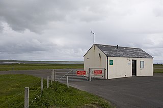
Westray Airport is an airport at Aikerness, on Westray in the Orkney Islands, Scotland. It is best known for being one of the two airports joined by the shortest scheduled flight in the world, a leg of Loganair's inter-island service to Papa Westray Airport. The distance is 2.8 km (1.7 mi) and the scheduled flight time, including taxiing, is two minutes. As well as the Papa Westray flights, services to the main Orkney town of Kirkwall are offered.
Newtownards Aerodrome is a local airfield in Newtownards, County Down, Northern Ireland. It is located 8.5 NM east of Belfast. This airport offers light aircraft flights, helicopter flights, microlight flights and flight simulator training. The airport also has an onsite restaurant.
Tresco Heliport is a heliport located on the island of Tresco, in the Isles of Scilly off the southwest coast of the United Kingdom. The heliport was served by a scheduled helicopter service from 1983 to 2012, and since 2020 a new scheduled service now operates from the new Penzance Heliport. Currently, Tresco Heliport offers a landing site for private and charter helicopters by private arrangement.
Lisbon Cascais-Tejo Regional Airport is a regional airport, situated near the village of Tires, in the civil parish of São Domingos de Rana, in the Portuguese municipality of Cascais, approximately 12 km (7.5 mi) northeast of town of the same name in the Greater Lisbon subregion.
Redcliffe Airport is an aerodrome serving Redcliffe in City of Moreton Bay, Queensland, Australia. It is located 2.5 nautical miles northwest of Redcliffe, in the suburb of Rothwell, accessed via Nathan Road. The facility is owned and operated by Moreton Bay City Council, following the amalgamation of the Redcliffe City Council.
Whitsunday Airport (Shute Harbour) (IATA: WSY, ICAO: YSHR) is located in Flametree in the Whitsunday Region, Queensland, Australia. It is located between the popular tourist destinations of Airlie Beach, Shute Harbour and the Whitsunday Islands.