List of airports in the Netherlands

Last updated

Map of the Netherlands Netherlands-CIA WFB Map.png
Map of the Netherlands

This is a list of airports in the Netherlands , grouped by type and sorted by location.

Contents

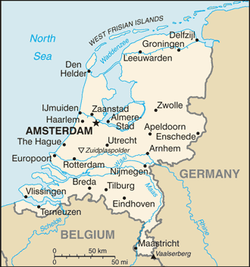
The largest airport by far is Amsterdam Airport Schiphol, which is the third largest in Europe. Smaller airports with scheduled passenger service are Rotterdam The Hague Airport (formerly known as Zestienhoven), Groningen Airport Eelde, Eindhoven Airport and Maastricht Aachen Airport. De Peel, Valkenburg and Soesterberg have been closed as military airports and are now mainly used by gliders. The future of the former military airport, Twente, is uncertain.

Rarely used helipads without an ICAO indicator, offshore oilrigs and small glider fields are not included in this list. Medical helipads have been assigned the identification codes EH0001 to EH0031 by the Dutch authorities, but these are not official ICAO indicators and thus these helipads are not included in this list. The Maasvlakte and IJmuiden helipads are restricted to maritime piloting services and are not connected to the AFTN network. Air Operations Control Station Nieuw-Milligen is a military air traffic control centre and has a single helipad for military use.

After the dissolution of the Netherlands Antilles the airports on Bonaire, Saba and Sint Eustatius became a part of the Netherlands, however they use the TN prefix instead of EH which is used for other Dutch airports.

Airports

ICAO location indicators are linked to the airport's Aeronautical Information Publication (AIP) from AIS the Netherlands.

Airport names shown in bold indicate the airport is used by scheduled airlines.

City served / Location Province ICAO IATA Airport nameCoordinates
Ameland / Ballum Friesland EHAL Ameland Airport 53°27′06″N005°40′38″E / 53.45167°N 5.67722°E / 53.45167; 5.67722 (Ameland Airport)
Amsterdam / Haarlemmermeer North Holland EHAM AMS Amsterdam Airport Schiphol 52°18′29″N004°45′51″E / 52.30806°N 4.76417°E / 52.30806; 4.76417 (Amsterdam Airport Schiphol)
Arnhem Gelderland EHTL Terlet Airfield 52°03′26″N005°55′28″E / 52.05722°N 5.92444°E / 52.05722; 5.92444 (Terlet Airfield (Arnhem))
Bonaire n/a (Caribbean Netherlands)TNCBBON Flamingo International Airport 12°07′51″N068°16′06″W / 12.13083°N 68.26833°W / 12.13083; -68.26833 (Flamingo International Airport (Bonaire))
Budel North Brabant EHBD Kempen Airport (Budel Airport) 51°15′16″N005°36′03″E / 51.25444°N 5.60083°E / 51.25444; 5.60083 (Kempen Airport (Weert))
Den Helder North Holland EHKD DHR Den Helder Airport
Marinevliegkamp (Naval Air Base) De Kooy
52°55′28″N004°46′51″E / 52.92444°N 4.78083°E / 52.92444; 4.78083 (Den Helder Airport)
Deventer / Apeldoorn / Teuge Gelderland EHTE Teuge Airport 52°14′41″N006°02′48″E / 52.24472°N 6.04667°E / 52.24472; 6.04667 (Teuge Airport (Apeldoorn))
Drachten Friesland EHDR Drachten Airfield 53°07′05″N006°07′45″E / 53.11806°N 6.12917°E / 53.11806; 6.12917 (Drachten Airfield)
Eindhoven North Brabant EHEH EIN Eindhoven Airport
Eindhoven Air Base
51°27′00″N005°22′28″E / 51.45000°N 5.37444°E / 51.45000; 5.37444 (Eindhoven Airport)
Enschede / Twente Overijssel EHTW ENS Enschede Airport Twente 52°16′33″N006°53′21″E / 52.27583°N 6.88917°E / 52.27583; 6.88917 (Enschede Airport Twente)
Groningen / Eelde Drenthe EHGG GRQ Groningen Airport Eelde 53°07′30″N006°35′00″E / 53.12500°N 6.58333°E / 53.12500; 6.58333 (Groningen Airport Eelde)
Hilversum North Holland EHHV Hilversum Airport 52°11′31″N005°08′49″E / 52.19194°N 5.14694°E / 52.19194; 5.14694 (Hilversum Airport)
Hoeven / Bosschenhoofd (Seppe) North Brabant EHSE Breda International Airport 51°33′17″N004°33′09″E / 51.55472°N 4.55250°E / 51.55472; 4.55250 (Breda International Airport (Hoeven))
Hoogeveen Drenthe EHHO Hoogeveen Airport 52°43′51″N006°30′58″E / 52.73083°N 6.51611°E / 52.73083; 6.51611 (Hoogeveen Airport)
Lelystad Flevoland EHLE LEY Lelystad Airport 52°27′37″N005°31′38″E / 52.46028°N 5.52722°E / 52.46028; 5.52722 (Lelystad Airport)
Maastricht / Beek Limburg EHBK MST Maastricht Aachen Airport 50°54′57″N005°46′37″E / 50.91583°N 5.77694°E / 50.91583; 5.77694 (Maastricht Aachen Airport)
Middelburg Zeeland EHMZ Midden-Zeeland Airport 51°30′44″N003°43′52″E / 51.51222°N 3.73111°E / 51.51222; 3.73111 (Midden-Zeeland Airport)
Middenmeer North Holland Middenmeer Aerodrome 52°49′00″N005°01′40″E / 52.81667°N 5.02778°E / 52.81667; 5.02778 (Middenmeer Aerodrome)
Rotterdam/The Hague South Holland EHRD RTM Rotterdam The Hague Airport 51°57′25″N004°26′14″E / 51.95694°N 4.43722°E / 51.95694; 4.43722 (Rotterdam The Hague Airport)
Saba n/a (Caribbean Netherlands)TNCSSAB Juancho E. Yrausquin Airport 17°38′43″N063°13′14″W / 17.64528°N 63.22056°W / 17.64528; -63.22056 (Juancho E. Yrausquin Airport (Saba))
Sint Eustatius n/a (Caribbean Netherlands)TNCEEUX F.D. Roosevelt Airport 17°29′47″N062°58′45″W / 17.49639°N 62.97917°W / 17.49639; -62.97917 (F.D. Roosevelt Airport (Sint Eustatius))
Stadskanaal Groningen EHST Stadskanaal Airfield 52°59′55″N007°01′22″E / 52.99861°N 7.02278°E / 52.99861; 7.02278 (Stadskanaal Airfield)
Texel / Den Burg North Holland EHTX Texel International Airport 53°06′55″N004°50′01″E / 53.11528°N 4.83361°E / 53.11528; 4.83361 (Texel International Airport)
Winschoten / Oostwold Groningen EHOW Oostwold Airport 53°12′29″N007°01′54″E / 53.20806°N 7.03167°E / 53.20806; 7.03167 (Oostwold Airport)
Arnhem Gelderland EHDL Deelen Air Base 52°03′33″N005°52′38″E / 52.05917°N 5.87722°E / 52.05917; 5.87722 (Deelen Air Base)
Eindhoven North Brabant EHEH EIN Eindhoven Airport
Eindhoven Air Base
51°27′00″N005°22′28″E / 51.45000°N 5.37444°E / 51.45000; 5.37444 (Eindhoven Airport)
Gilze-Rijen North Brabant EHGRGLZ Gilze-Rijen Air Base 51°34′06″N004°55′36″E / 51.56833°N 4.92667°E / 51.56833; 4.92667 (Gilze-Rijen Air Base)
Leeuwarden Friesland EHLWLWR Leeuwarden Air Base 53°13′40″N005°45′36″E / 53.22778°N 5.76000°E / 53.22778; 5.76000 (Leeuwarden Air Base)
Leiden South Holland EHVBLID Valkenburg Naval Air Base (closed) 52°10′00″N004°25′09″E / 52.16667°N 4.41917°E / 52.16667; 4.41917 (Valkenburg Naval Air Base)
Nieuw-Milligen Gelderland EHMC / EHML Air Operations Control Station Nieuw-Milligen 52°14′07″N005°45′00″E / 52.23528°N 5.75000°E / 52.23528; 5.75000 (Air Operations Control Station Nieuw-Milligen)
Soesterberg Utrecht EHSBUTC Soesterberg Air Base (closed) 52°07′39″N005°16′26″E / 52.12750°N 5.27389°E / 52.12750; 5.27389 (Soesterberg Air Base)
Uden North Brabant EHVKUDE Volkel Air Base 51°39′26″N005°41′34″E / 51.65722°N 5.69278°E / 51.65722; 5.69278 (Volkel Air Base (Uden))
Venray Limburg EHDP De Peel Air Base (closed) 51°31′04″N005°51′34″E / 51.51778°N 5.85944°E / 51.51778; 5.85944 (De Peel Air Base (Venray))
Woensdrecht North Brabant EHWOWOE Woensdrecht Air Base 51°26′56″N004°20′30″E / 51.44889°N 4.34167°E / 51.44889; 4.34167 (Woensdrecht Air Base)
Amsterdam North Holland EHHA Amsterdam Heliport 52°24′56″N004°48′01″E / 52.41556°N 4.80028°E / 52.41556; 4.80028 (Amsterdam Heliport)
Ede Gelderland Lukkien Heliport 52°01′22″N005°37′26″E / 52.02278°N 5.62389°E / 52.02278; 5.62389 (Lukkien Heliport)
Emmer Compascuum Drenthe Heli Holland Heliport 52°48′12″N006°57′26″E / 52.80333°N 6.95722°E / 52.80333; 6.95722 (Heli Holland Heliport)
Harskamp Gelderland Harskamp Heliport 52°07′28″N005°44′07″E / 52.12444°N 5.73528°E / 52.12444; 5.73528 (Harskamp Heliport)
Heythuysen Limburg Helico Heliport 51°14′34″N005°54′19″E / 51.24278°N 5.90528°E / 51.24278; 5.90528 (Helico Heliport)
IJmuiden North Holland EHYM IJmuiden Heliport (YPAD) 52°28′12″N004°35′42″E / 52.47000°N 4.59500°E / 52.47000; 4.59500 (IJmuiden Heliport)
Rotterdam South Holland EHTP Maasvlakte Heliport 51°57′34″N004°05′24″E / 51.95944°N 4.09000°E / 51.95944; 4.09000 (Maasvlakte Heliport)
Vlieland Friesland EHVL Vlieland Heliport 53°17′48″N005°05′09″E / 53.29667°N 5.08583°E / 53.29667; 5.08583 (Vlieland Heliport)

See also

References

Map all coordinates using: OpenStreetMap