Kinney County is a county located in the U.S. state of Texas. As of the 2010 census, its population was 3,598. Its county seat is Brackettville. The county was created in 1850 and later organized in 1874. It is named for Henry Lawrence Kinney, an early settler.
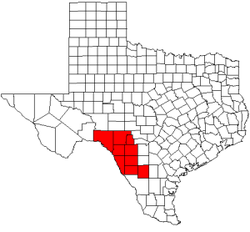
Dimmit County is a county located in the U.S. state of Texas. As of the 2010 census, its population was 9,996. The county seat is Carrizo Springs. The county was founded in 1858 and later organized in 1880. It's named for Philip Dimmitt, a major figure in the Texas Revolution. The spelling of the county name and the individual's name differ because of a spelling error in the bill creating the county name.
Scouting in Texas has a long history, from the 1910s to the present day, serving thousands of youth in programs that suit the environment in which they live. Scouting, also known as the Scout Movement, is a worldwide youth movement with the stated aim of supporting young people in their physical, mental and spiritual development, so that they may play constructive roles in society.

Asherton is a city in Dimmit County, Texas, United States. The population was 1,084 at the 2010 census, down from 1,342 at the 2000 census. The estimated population in 2018 was 1,064. U.S. Highway 83 runs through Asherton.
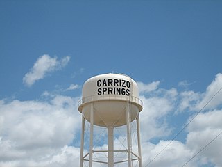
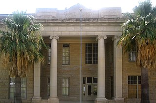
Carrizo Springs is the largest city in, and the county seat of, Dimmit County, Texas, United States. The population was 5,368 at the 2010 census..

Edinburg is a city in and the county seat of Hidalgo County, Texas, United States. The population was 74,569 as of the 2010 census, and in 2019 the estimated population was 101,170, making it the second largest city in Hidalgo County, and the third largest city in the larger Rio Grande Valley region.

Uvalde is a city in and the county seat of Uvalde County, Texas, United States. The population was 15,751 at the 2010 census.

Crystal City is a city in and the county seat of Zavala County, Texas, United States. The population was 7,138 at the 2010 census. It was settled as a farming and ranching community and was a major railroad stop being 110 miles (180 km) from San Antonio. Spinach became a major crop and the city has promoted itself as "Spinach Capital of the World." During World War II, a large internment camp was located here. The town is also noteworthy in the history of Mexican American political self-determination for the founding of the La Raza Unida Party.

The Lower Rio Grande Valley, commonly known as the Rio Grande Valley or locally as The Valley, is a socio-cultural region spanning the border of Texas and Mexico located in a floodplain of the Rio Grande near its mouth. The region includes the southernmost tip of South Texas and a portion of northern Tamaulipas, Mexico. It consists of the Brownsville, Harlingen, Weslaco, Pharr, McAllen, Edinburg, Mission, San Juan, and Rio Grande City metropolitan areas in the United States and the Matamoros, Río Bravo, and Reynosa metropolitan areas in Mexico. These cities are surrounded by many small neighborhoods or colonias. The area is generally bilingual in English and Spanish, with a fair amount of Spanglish due to the diverse history of the region. A large seasonal influx occurs of "winter Texans" — Texans who come down from the north for the winter and then go back up north before summer arrives.

Sul Ross State University (SRSU) is a public university in Alpine, Texas. The main campus is the primary institution of higher education serving the nineteen-county Big Bend region of far West Texas. Branch campuses, branded as Rio Grande College, are located in Del Rio, Uvalde, Eagle Pass, and Castroville.

The Nueces River is a river in the U.S. state of Texas, about 315 miles (507 km) long. It drains a region in central and southern Texas southeastward into the Gulf of Mexico. It is the southernmost major river in Texas northeast of the Rio Grande. Nueces is Spanish for nuts; early settlers named the river after the numerous pecan trees along its banks.
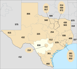
Area code 830 is the telephone area code in the North American Numbering Plan (NANP) for the Texas Hill Country and most of San Antonio's suburbs. It completely surrounds area codes 210 and 726, which serve most of San Antonio itself along with its innermost suburbs.

The Lower Rio Grande Valley Development Council (LRGVDC) is a voluntary association of cities, counties and special districts in the Rio Grande Valley region of southern Texas.

Based in Laredo, South Texas Development Council (STDC) is a voluntary association of cities, counties and special districts in southern Texas.
The Rio Grande Council of Governments (RGCOG) is a voluntary association of cities, counties and special districts in West Texas and Doña Ana County, New Mexico
U.S. Highway 83 (US 83), dedicated as the Texas Vietnam Veterans Memorial Highway, is a U.S. Highway in the U.S. state of Texas that begins at US 77 in Brownsville and follows the Rio Grande to Laredo, then heads north through Abilene to the Oklahoma border north of Perryton, the seat of Ochiltree County. It is the longest highway in Texas at a length of about 895 miles (1,440 km), besting the east–west I-10, which has a length of 879 miles (1,415 km), and it is also the longest stretch of a U.S. highway within a single U.S. state.

Eagle Pass is a city in and the county seat of Maverick County in the U.S. state of Texas. Its population was 26,255 as of the 2010 census.
The San Antonio–El Paso Road, also known as the Lower Emigrant Road or Military Road, was an economically important trade route between the Texas cities of San Antonio and El Paso between 1849 and 1882. Mail, freight, and passengers traveled by horse and wagon along this road across the Edwards Plateau and dangerous Trans-Pecos region of West Texas.
The San Antonio and Aransas Pass Railway first began operation in the U.S. state of Texas in 1886. It was developed by Uriah Lott and businessmen of San Antonio as a direct route from the city to Aransas Bay on the Texas Gulf coast. It was eventually absorbed in the 20th century by Southern Pacific.
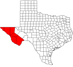
Tracy Ogden King is a businessman from Batesville, Texas, who has been since 1995 a Democratic member of the Texas House of Representatives from District 80. Beginning in January 2013, the revised District 80 includes these counties south of San Antonio: Dimmit, Frio, Uvalde, Zapata, Zavala plus the rural portions of Webb County outside Laredo.