
Upshur County is a county located in the eastern part of the U.S. state of Texas. As of the 2020 census, the population was 40,892. The county seat is Gilmer. The county is named for Abel P. Upshur, who was U.S. Secretary of State during President John Tyler's administration.

Smith County is a county in the U.S. state of Texas. As of the 2020 census, its population was 233,479. Its county seat is Tyler. Smith County is named for James Smith, a general during the Texas Revolution.

Rusk County is a county located in Texas. As of the 2020 census, its population was 52,214. Its county seat is Henderson. The county is named for Thomas Jefferson Rusk, a secretary of war of the Republic of Texas.

Panola County is a county located in the U.S. state of Texas. As of the 2020 census, its population was 22,491. The county seat is Carthage. Located in East Texas and originally developed for cotton plantations, the county's name is derived from a Choctaw word for cotton.

Harrison County is a county on the eastern border of the U.S. state of Texas. As of the 2020 United States census, its population was 68,839. The county seat is Marshall. The county was created in 1839 and organized in 1842. It is named for Jonas Harrison, a lawyer and Texas revolutionary.

Gregg County is a county located in the eastern part of the U.S. state of Texas. As of the 2020 census, its population was 124,239. Its county seat is Longview. The county is named after John Gregg, a Confederate general killed in action during the American Civil War.
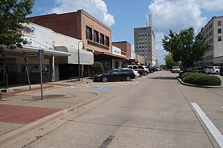
Marshall is a city in the U.S. state of Texas. It is the county seat of Harrison County and a cultural and educational center of the Ark-La-Tex region. At the 2020 U.S. census, the population of Marshall was 23,392; The population of the Greater Marshall area, comprising all of Harrison County, was 65,631 in 2010, and 66,726 in 2018.

Kilgore is a city in Gregg and Rusk counties in the eastern part of the U.S. state of Texas. Over three-fourths of the area within city limits are located in Gregg County, the remainder in Rusk County. The population was 12,975 at the 2010 census and 13,376 at the 2020 census.
Longview is a city in and county seat of Gregg County, Texas, United States. Longview is located in East Texas, where Interstate 20 and U.S. highways 80 and 259 converge just north of the Sabine River. According to the 2020 U.S. census, the city had a population of 81,638. Longview is the principal city of the Longview metropolitan statistical area, comprising Gregg, Upshur, and Rusk counties. The population of the metropolitan area as of 2021 census estimates was 287,858.

East Texas is a broadly defined cultural, geographic, and ecological region in the eastern part of the U.S. state of Texas that comprises most of 41 counties. It is primarily divided into Northeast and Southeast Texas. Most of the region consists of the Piney Woods ecoregion. East Texas can sometimes be defined only as the Piney Woods. At the fringes, towards Central Texas, the forests expand outward toward sparser trees and eventually into open plains.

Northeast Texas is a cultural and geographic region in the northeast corner of the U.S. state of Texas. Geographically centered on two metropolitan areas strung along Interstate 20—Tyler in the west and Longview/Marshall to the east, the areas of Greenville, Mount Pleasant, Sulphur Springs, Paris, and Texarkana in the north primarily along Interstate 30, and Jacksonville and Palestine to the south are also major cities within the region. Most of Northeast Texas is included in the interstate region of the Ark-La-Tex.
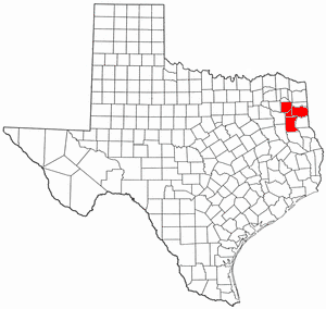
The Longview–Marshall Combined Statistical Area covers four counties in Northeast Texas. The statistical area consists of the Longview Metropolitan Statistical Area and the Marshall Micropolitan Statistical Area. Prior to 2003, the area was known as the Longview–Marshall Metropolitan Statistical Area, which consisted of Gregg, Harrison, Rusk, and Upshur counties. As of the 2000 census, the CSA had a population of 256,152.

District 1 of the Texas Senate is a senatorial district that serves all of Bowie, Camp, Cass, Delta, Franklin, Gregg, Harrison, Lamar, Marion, Morris, Panola, Red River, Rusk, Smith, Titus, Upshur, and Wood counties in the U.S. state of Texas. The current senator from District 1 is Bryan Hughes.
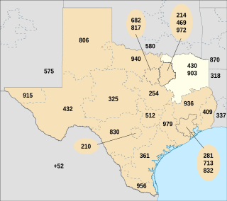
Area codes 903 and 430 are telephone area codes in the North American Numbering Plan (NANP) for the northeastern part of the U.S. state of Texas, including Texarkana, Tyler, and Sherman. The numbering plan area begins just north and east of the Dallas–Fort Worth metroplex, and extends to the Oklahoma, Arkansas, and Louisiana state borders. Area code 903 was created November 4, 1990 in a split of area code 214. Area code 430 was assigned to the same service area on February 15, 2003 in creation of an overlay. Before October 18, 1980, area code 903 was assigned to an area in northwestern Mexico.

The North East Texas Regional Mobility Authority is a Regional Mobility Authority covering several counties in the U.S. state of Texas. The NET RMA was created by the Texas Transportation Commission in 2004, originally containing the counties of Smith and Gregg. It was the 5th RMA established in the State of Texas, and is headquartered in Tyler. The authority claims to "provide solutions to expedite transportation and mobility projects that will improve the quality of life, enhance the regional economy and assure efficient mobility in the North East Texas Region."
Cherokee Lake, also known as Cherokee Reservoir, is an artificial reservoir in the U.S. state of Tennessee formed by the impoundment of the Holston River behind Cherokee Dam.

The 1996 United States presidential election in Texas took place on November 5, 1996. All fifty states, and the District of Columbia, took part in the 1996 United States presidential election. State voters chose 32 electors to the Electoral College, which selected the president and vice president.
