Zapata County is a county located in the U.S. state of Texas. As of the 2010 census, its population was 14,018. Its county seat is Zapata. The county is named for Colonel José Antonio de Zapata, a rancher in the area who rebelled against Mexico.

Webb County is a county located in the U.S. state of Texas. As of the 2010 census, its population was 250,304. Its county seat is Laredo. The county was named after James Webb (1792–1856), who served as secretary of the treasury, secretary of state, and attorney general of the Republic of Texas, and later judge of the United States District Court following the admission of Texas to statehood. By area, Webb County is the largest county in South Texas and the sixth-largest in the state. Webb County includes the Laredo metropolitan area. Webb County is the only county in the United States to border three foreign states or provinces, sharing borders with Coahuila, Nuevo Leon, and Tamaulipas.

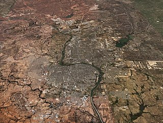
Laredo is a city in and the county seat of Webb County, Texas, United States, on the north bank of the Rio Grande in South Texas, across from Nuevo Laredo, Tamaulipas, Mexico. Laredo has the distinction of flying seven flags. Founded in 1755, Laredo grew from a village to the capital of the brief Republic of the Rio Grande to the largest inland port on the Mexican border. Laredo's economy is based on international trade with Mexico. Many major transportation companies have a facility in Laredo. The city is on the southern end of I-35, which makes it close to the manufacturers in northern Mexico. It has four international bridges and one railway bridge.
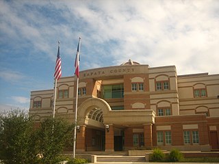
Zapata is a census-designated place (CDP) in and the county seat of Zapata County, Texas, United States. The population was 14,018 at the 2010 census. As an unincorporated community, Zapata has no municipal government but like all 254 Texas counties has four elected county commissioners chosen by single-member districts and a countywide elected administrative judge.

Santos Benavides was a Confederate colonel during the American Civil War. Benavides was the highest-ranking Tejano soldier in the Confederate military.

South Texas is a region of the U.S. state of Texas that lies roughly south of—and including—San Antonio. The southern and western boundary is the Rio Grande, and to the east it is the Gulf of Mexico. The population of this region is about 4.96 million according to the 2017 census estimates. The southern portion of this region is often referred to as the Rio Grande Valley. The eastern portion along the Gulf of Mexico is also referred to as the Coastal Bend.

The Republic of the Rio Grande was an independent nation that insurgents fighting against the Centralist Republic of Mexico sought to establish in northern Mexico. The Republic of the Rio Grande was just one of a series of independence movements in Mexico under the unitary government dominated by Santa Anna, including the Republic of Texas, the Republic of Zacatecas, and the Republic of Yucatán. The rebellion lasted from 17 January to 6 November 1840.

The United States District Court for the Southern District of Texas is the Federal district court with jurisdiction over the southern part of Texas. The court's headquarters is in Houston, Texas and has six additional offices in the district.
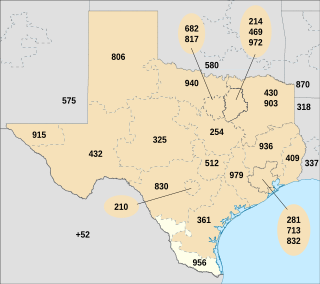
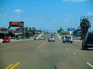
North American area code 956 is a state of Texas telephone area code for numbers in the Brownsville, McAllen, Laredo and South Padre Island areas. It was created May 25, 1997, in a split from area code 210.
United Independent School District is a school district headquartered in Laredo, Texas.
Lyndon B. Johnson High School is a secondary school located in Laredo, Texas, United States. LBJHS is a part of the United Independent School District, and it serves a portion of south Laredo and the neighboring cities of El Cenizo and Rio Bravo. Home of the BLISIA early college and regular early college.

Laredo College (LC) is a public college in Laredo, Texas. Founded as Laredo Junior College in 1947, it is part of the Laredo Independent School District. As defined by the Texas Legislature, the official service area of LC includes the municipality of Laredo and all of Webb, Jim Hogg and Zapata counties.

The Laredo National Bank (LNB) was a Texas bank founded in 1892 headquartered in Laredo, Texas which was bought by Banco Bilbao Vizcaya Argentaria. LNB had been a component in the development of business and industry along the United States-Mexico border and South Texas. The Laredo National Bank had grown to approximately $3.5 billion in assets and was the fifth largest independent bank in Texas. Headquartered in Laredo, Texas, LNB had branches in Austin, Brownsville, Corpus Christi, Dallas, Del Rio, Eagle Pass, Harlingen, Houston, McAllen, San Antonio, San Marcos, and Weslaco. Laredo National Bank owned South Texas National Bank. Laredo National Bank's branches and headquarters names have been changed to Compass Bank on November 14, 2008 due to a merger between Laredo National Bank Compass and BBVA. BBVA Compass plans on cutting 170 jobs and eliminating the Laredo National Bank headquarters.
Laredo–Nuevo Laredo is one of six transborder agglomerations along the U.S.-Mexican border. The city of Laredo is situated in the U.S. state of Texas on the northern bank of the Rio Grande and Nuevo Laredo is located in the Mexican State of Tamaulipas in the southern bank of the river. This area is also known as the Two Laredos or the Laredo Borderplex. The area is made up of one county: Webb County in Texas and three municipalities: Nuevo Laredo Municipality in Tamaulipas, Hidalgo Municipality in Coahuila, Anáhuac Municipality in Nuevo León in Mexico. Two urban areas: the Laredo Metropolitan Statistical Area and the Zona Metropolitana Nuevo Laredo three cities and 12 towns make the Laredo–Nuevo Laredo Metropolitan area which has a total of 636,516 inhabitants according to the INEGI Census of 2010 and the United States Census estimate of 2010. The Laredo–Nuevo Laredo is connected by four International Bridges and an International Railway Bridge. According to World Gazetteer this urban agglomeration ranked 157th largest in North and South America in 2010 with an estimated population of 775,481. This area ranks 66th in the United States and 23rd in Mexico.
The Zapata Times is a weekly newspaper publication in Zapata, Texas, USA. It is produced by the Laredo Morning Times which is owned by the Hearst Corporation. The Zapata Times was first published on August 16, 2008 and is delivered every Saturday to 4,000 homes in Zapata County free of charge
State Highway Spur 260 (Spur 260), also known as Jaime Zapata Memorial Highway, is a state highway in southeastern Laredo, Texas, connecting U.S. Highway 83 (US 83) and State Highway 359 (SH 359). The route was designated in 2008 but continued to be signed as part of State Highway Loop 20 (Loop 20) until the opening of Cuatro Vientos Road in July 2011, when the Loop 20 designation was shifted to the new route. The contemporary Spur 260 constitutes the original extent of Loop 20, as originally designated in 1939.

The Great Texas Coastal Birding Trail is a state-designated system of trails, bird sanctuaries, and nature preserves along the entire length of the Texas Gulf Coast in the United States. As the state of Texas hosts more bird species than any other state in the U.S. the trail system offers some of the most unusual opportunities for bird-watching in the world. The "trail" is actually 43 separate hiking and driving trails that include 308 birding sites. The sites themselves feature a variety of viewing opportunities with boardwalks, observation decks, and other amenities. The trails boast more than 450 bird species. The trail system is managed by the Texas Parks and Wildlife Department as part of the Great Texas Wildlife Trails which also include the Heart of Texas Wildlife Trail, the Panhandle Plains Wildlife Trail, and the Prairies and Pineywoods Wildlife Trail.

Matamoros–Brownsville, also known as Brownsville–Matamoros, or simply as the Borderplex, is one of the six transborder agglomerations along the Mexico–United States border. The city of Matamoros is situated in the Mexican state of Tamaulipas, on the south bank of the Rio Grande, while the city of Brownsville is located in the U.S. state of Texas, directly north across the bank of the Rio Grande. The Matamoros–Brownsville area is connected by four international bridges. In addition, this transnational conurbation area has a population of 1,136,995, making it the fourth-largest metropolitan area on the Mexico-U.S. border.
Jesús de Cárdenas was the Governor of Tamaulipas and the President of the Republic of the Rio Grande.
The following is a timeline of the history of the city of Laredo, Texas, USA.
