Konradówka is a village in the administrative district of Gmina Chojnów, within Legnica County, Lower Silesian Voivodeship, in south-western Poland. Prior to 1945 it was in Germany.

Barkowo is a village in the administrative district of Gmina Żmigród, within Trzebnica County, Lower Silesian Voivodeship, in south-western Poland. Prior to 1945 it was in Germany.

Stalówka is a village in the administrative district of Gmina Kcynia, within Nakło County, Kuyavian-Pomeranian Voivodeship, in north-central Poland. It lies approximately 2 kilometres (1 mi) north of Kcynia, 17 km (11 mi) south-west of Nakło nad Notecią, and 38 km (24 mi) west of Bydgoszcz.
Staszyce is a village in the administrative district of Gmina Wierzbica, within Chełm County, Lublin Voivodeship, in eastern Poland. It lies approximately 3 kilometres (2 mi) east of Wierzbica, 16 km (10 mi) north-west of Chełm, and 55 km (34 mi) east of the regional capital Lublin.

Mazımqarışan is a former village in the Balakan Rayon of Azerbaijan. The village forms part of the municipality of Tülü.
Ardıclı is a village in the Lachin Rayon of Azerbaijan.
Nord-Ost-Kultuk is a village in the Neftchala Rayon of Azerbaijan.
Dąbrowa is a village in the administrative district of Gmina Tomaszów Lubelski, within Tomaszów Lubelski County, Lublin Voivodeship, in eastern Poland.
Gruszów is a village in the administrative district of Gmina Pałecznica, within Proszowice County, Lesser Poland Voivodeship, in southern Poland.
Szewce is a village in the administrative district of Gmina Sitkówka-Nowiny, within Kielce County, Świętokrzyskie Voivodeship, in south-central Poland. It lies approximately 6 kilometres (4 mi) north-west of Osiedle-Nowiny and 11 km (7 mi) south-west of the regional capital Kielce.
Helenów is a village in the administrative district of Gmina Gostynin, within Gostynin County, Masovian Voivodeship, in east-central Poland.
Zapceń is a village in Gmina Lipnica, Bytów County, Pomeranian Voivodeship, in northern Poland. It lies approximately 12 kilometres (7 mi) south of Bytów and 53 km (33 mi) south-west of Gdańsk.
Klucza is a settlement in the administrative district of Gmina Chojnice, within Chojnice County, Pomeranian Voivodeship, in northern Poland. It lies approximately 16 kilometres (10 mi) north of Chojnice and 96 km (60 mi) south-west of the regional capital Gdańsk.
Parszkowo is a village in the administrative district of Gmina Krokowa, within Puck County, Pomeranian Voivodeship, in northern Poland. It lies approximately 7 kilometres (4 mi) east of Krokowa, 12 km (7 mi) north-west of Puck, and 51 km (32 mi) north-west of the regional capital Gdańsk.
Sowy is a village in the administrative district of Gmina Janowiec Kościelny, within Nidzica County, Warmian-Masurian Voivodeship, in northern Poland. It lies approximately 4 kilometres (2 mi) south of Janowiec Kościelny, 12 km (7 mi) south-east of Nidzica, and 58 km (36 mi) south of the regional capital Olsztyn.
Mielęcin is a village in the administrative district of Gmina Krzęcin, within Choszczno County, West Pomeranian Voivodeship, in north-western Poland. It lies approximately 4 kilometres (2 mi) south of Krzęcin, 14 km (9 mi) south of Choszczno, and 72 km (45 mi) south-east of the regional capital Szczecin.
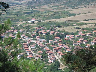
Kalimantsi is a village in southwestern Bulgaria. It is located in the municipality of Sandanski in the Blagoevgrad Province.
Kabeli is a village in Viru-Nigula Parish, Lääne-Viru County, in northeastern Estonia.

Brezici (Maglaj) is a village in the municipality of Maglaj, Bosnia and Herzegovina.
Inishgort is an island in Clew Bay, County Mayo. Inishgort is home to Inishgort lighthouse, originally opened in 1806


