Milo (CDP), Maine

Last updated

Milo, Maine
CDP
Milo from River, Milo, ME.jpg
Piscataquis County Maine incorporated and unincorporated areas Milo (CDP) highlighted.svg
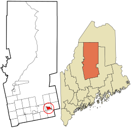
Location in Piscataquis County and the state of Maine.
USA Maine location map.svg
Red pog.svg
Milo, Maine
Location within the state of Maine
Coordinates: 45°15′1″N68°58′59″W / 45.25028°N 68.98306°W / 45.25028; -68.98306 Coordinates: 45°15′1″N68°58′59″W / 45.25028°N 68.98306°W / 45.25028; -68.98306
CountryUnited States
State Maine
County Piscataquis
Area
[1]
  Total8.06 sq mi (20.86 km2)
  Land7.75 sq mi (20.07 km2)
  Water0.31 sq mi (0.80 km2)
Elevation
318 ft (97 m)
Population
 (2020)
  Total1,751
  Density225.99/sq mi (87.26/km2)
Time zone UTC-5 (Eastern (EST))
  Summer (DST) UTC-4 (EDT)
ZIP code
04463
Area code 207
FIPS code 23-45985
GNIS feature ID0571407

Milo is a census-designated place (CDP) in the town of Milo in Piscataquis County, Maine, United States. The population was 1,898 at the 2000 census.

Contents

Geography

Milo is located at 45°15′0″N68°58′59″W / 45.25000°N 68.98306°W / 45.25000; -68.98306 (45.250182, −68.983186). [2]

According to the United States Census Bureau, the CDP has a total area of 8.0 square miles (20.8 km2), of which, 7.8 square miles (20.1 km2) of it is land and 0.2 square miles (0.6 km2) of it (3.12%) is water. Milo is located at the confluence of the Sebec River with the Piscataquis River.

Demographics

Historical population
CensusPop.
2020 1,751
U.S. Decennial Census [3]

As of the census [4] of 2000, there were 1,898 people, 830 households, and 522 families residing in the CDP. The population density was 244.2 inhabitants per square mile (94.3/km2). There were 977 housing units at an average density of 125.7 per square mile (48.5/km2). The racial makeup of the CDP was 98.52% White, 0.42% Black or African American, 0.42% Native American, 0.11% Asian, 0.05% from other races, and 0.47% from two or more races. Hispanic or Latino of any race were 0.21% of the population.

There were 830 households, out of which 28.4% had children under the age of 18 living with them, 48.6% were married couples living together, 10.2% had a female householder with no husband present, and 37.0% were non-families. 31.2% of all households were made up of individuals, and 17.8% had someone living alone who was 65 years of age or older. The average household size was 2.29 and the average family size was 2.84.

In the CDP, the population was spread out, with 24.0% under the age of 18, 7.1% from 18 to 24, 26.7% from 25 to 44, 22.5% from 45 to 64, and 19.8% who were 65 years of age or older. The median age was 41 years. For every 100 females, there were 84.5 males. For every 100 females age 18 and over, there were 88.4 males.

The median income for a household in the CDP was $23,870, and the median income for a family was $32,094. Males had a median income of $29,833 versus $19,554 for females. The per capita income for the CDP was $12,752. About 13.4% of families and 17.2% of the population were below the poverty line, including 22.1% of those under age 18 and 14.2% of those age 65 or over.

Related Research Articles

<span class="mw-page-title-main">Piscataquis County, Maine</span> County in Maine, United States

Piscataquis County is a county located in the U.S. state of Maine. As of the 2020 census, its population was 16,800, making it Maine's least-populous county. Its county seat is Dover-Foxcroft. The county was incorporated on March 23, 1838, taken from the western part of Penobscot County and the eastern part of Somerset County. It is named for an Abenaki word meaning "branch of the river" or "at the river branch."

<span class="mw-page-title-main">North River Shores, Florida</span> Census-designated place in Florida, United States

North River Shores is an unincorporated area and census-designated place (CDP) in Martin County, Florida, United States. The population was 3,459 at the 2020 census, up from 3,079 in 2010. It is part of the Port St. Lucie Metropolitan Statistical Area.

<span class="mw-page-title-main">Zephyrhills North, Florida</span> CDP in Florida, United States

Zephyrhills North is a census-designated place (CDP) in Pasco County, Florida, United States. The population was 2,544 at the 2000 census.

Gages Lake is a census-designated place (CDP) in Warren Township, Lake County, Illinois, United States. The population was 10,637 at the 2020 census.

<span class="mw-page-title-main">Abbot, Maine</span> Town in the state of Maine, United States

Abbot is a town in Piscataquis County, Maine, United States. The population was 650 at the 2020 census. It was named for the treasurer of Bowdoin College, John Abbot.

<span class="mw-page-title-main">Lake View Plantation, Maine</span> Plantation in Maine, United States

Lake View is a plantation in Piscataquis County, Maine, United States. The population was 150 at the 2020 census.

<span class="mw-page-title-main">Medford, Maine</span> Town in the state of Maine, United States

Medford is a town in Piscataquis County, Maine, United States. The population was 230 at the 2020 census.

<span class="mw-page-title-main">Valencia, Valencia County, New Mexico</span> CDP in New Mexico, United States

Valencia is a census-designated place (CDP) in Valencia County, New Mexico, United States. The population was 2,192 at the 2010 census. It is part of the Albuquerque Metropolitan Statistical Area.

<span class="mw-page-title-main">Fairfield Beach, Ohio</span> Census-designated place in Ohio, United States

Fairfield Beach is an unincorporated community and census-designated place (CDP) in Fairfield County, Ohio, United States. The population was 1,292 at the 2010 census.

<span class="mw-page-title-main">South Canal, Ohio</span> CDP in Ohio, United States

South Canal is a census-designated place (CDP) in Trumbull County, Ohio, United States. The population was 1,346 at the 2000 census. It is part of the Youngstown–Warren–Boardman, OH-PA Metropolitan Statistical Area.

<span class="mw-page-title-main">Pine Creek Township, Jefferson County, Pennsylvania</span> Township in Pennsylvania, United States

Pine Creek Township is a township in Jefferson County, Pennsylvania, United States. The population was 1,351 at the 2020 census. The township was named for the abundance of pine trees in the area.
<span class="mw-page-title-main">Evansburg, Pennsylvania</span> Census-designated place in Pennsylvania, United States

Evansburg is a census-designated place (CDP) in Montgomery County, Pennsylvania, United States. The population was 2,129 at the 2010 census. It is a section of Lower Providence Township and is the namesake of Evansburg State Park.

<span class="mw-page-title-main">Osage, Wyoming</span> CDP in Wyoming, United States

Osage is a census-designated place (CDP) in Weston County, Wyoming, United States. The population was 151 at the 2020 census.

<span class="mw-page-title-main">Brownville (village), New York</span> Village in New York, United States

Brownville is a village in Jefferson County, New York, United States. The population was 1,119 at the 2010 census, up from 1,022 in 2000. The village is named after Jacob Brown, an early settler and developer.

Millinocket is a census-designated place (CDP) comprising most of the developed land within the town of Millinocket in Penobscot County, Maine, United States. The population of the CDP was 4,466 at the 2010 census.
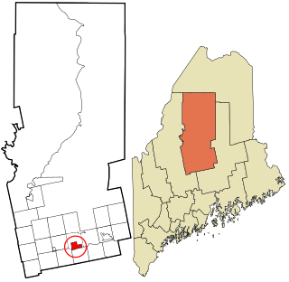
Newport is a census-designated place (CDP) consisting of the main area of settlement within the town of Newport in Penobscot County, Maine, United States. The population of the CDP was 1,776 at the 2010 census.

<span class="mw-page-title-main">Dover-Foxcroft (CDP), Maine</span> CDP in Maine, United States

Dover-Foxcroft is a census-designated place (CDP) in the town of Dover-Foxcroft in Piscataquis County, Maine, United States. The population was 2,592 at the 2000 census.

<span class="mw-page-title-main">Greenville (CDP), Maine</span> CDP in Maine, United States

Greenville is a census-designated place (CDP) in the town of Greenville in Piscataquis County, Maine, United States. The population was 1,319 at the 2000 census.

<span class="mw-page-title-main">Guilford (CDP), Maine</span> CDP in Maine, United States

Guilford is a census-designated place (CDP) in the town of Guilford in Piscataquis County, Maine, United States. The population was 945 at the 2000 census.

Manchester is a census-designated place (CDP) in Hartford County, Connecticut, United States, comprising the urban center of the town of Manchester. As of the 2010 census, the population of the CDP was 30,577, out of 58,241 in the entire town.

References

  1. "2020 U.S. Gazetteer Files". United States Census Bureau. Retrieved April 8, 2022.
  2. "US Gazetteer files: 2010, 2000, and 1990". United States Census Bureau. February 12, 2011. Retrieved April 23, 2011.
  3. "Census of Population and Housing". Census.gov. Retrieved June 4, 2016.
  4. "U.S. Census website". United States Census Bureau . Retrieved January 31, 2008.