General geology
In the broader physiographic framework of the Philippine archipelago, Caraga Region occupies the northernmost portion of the Eastern Mindanao Ridge or Mindanao Pacific Cordillera, a more than 400-km, NNW-SSE trending orogenic belt comprising eastern Mindanao. The Mindanao Pacific Cordillera is bounded by two major structures that played a key role in the neotectonic evolution of the Philippine Mobile Belt, namely the Philippine Trench and the Philippine Fault Zone.
The geologic evolution of the Mindanao Pacific Cordillera was largely controlled by convergent and transcurrent tectonics intermittently active during Upper Cretaceous to Pleistocene times. These complex tectonic processes brought about the juxtaposition of older metamorphic basement rocks with ophiolite suite of rocks later superposed by younger multiple stage island arc volcano-sedimentary sequences. The broad geomorphic configuration of the region is largely controlled by these tectonic processes of the past.
Oldest rocks in the region are pre-Tertiary metamorphics and ophiolitic suite of rocks of Cretaceous age. Limited exposures of post-ophiolitic sedimentary rocks of Eocene age suggest dominant erosional processes from Paleocene to Eocene period. On the contrary, the Oligocene to Middle Miocene age is marked by thick accumulation of arc basaltic volcano-sedimentary sequence and turbidites later succeeded by mid-Miocene to Pliocene volcanic flows, pyroclastics and epiclastic of more andesitic composition. Arc magmatism was also active during the mid-Miocene to Pliocene times generating monzonitic and dioritic stocks and plutons and hornblende andesite porphyry intrusions. In areas away from paleo-volcanic centers, thick sedimentary clastic rocks with sporadic limestone horizons and intercalated calcareous sediments, marls and/or coal seams were formed during the Miocene to Pliocene. Reefal limestone, some of dubious stratigraphic position unconformably capped older rocks with age assignment ranging from Miocene to Plio-Pleistocene. The Paco-Maniayao volcanic complex north of Lake Mainit represents the latest Quaternary volcanism in the region.
Ophiolite and associated nickel and chromite deposits
Caraga Region is situated in the Samar – Surigao segment of the Eastern Bicol – Eastern Mindanao ophiolite belt, one of the nine (9) major ophiolite. Ophiolites, particularly the ultramafic member of the assemblage, are of economic significance as they play host to two strategic ferro-alloy metallic commodities namely nickel and chromium. Large tracts of ultramafic terrains are exposed in the province of Surigao del Norte and northern Surigao del Sur, a majority of which are within the Surigao Mineral Reservation (SMR). Minor occurrences can also be found in the western range of Agusan del Norte.
The nickel resources of the region are in the form of nickeliferous laterites, soils of unique geochemistry derived from the tropical weathering of parent serpentinized ultramafites. Two types of nickel ore are of commercial importance, limonite (oxide) ore and saprolite (nickel silicate) ore. Nickel content is higher in the saprolite zone although cobalt is an important by-product of the limonite horizon. Potential is high in Surigao del Norte and northern Surigao del Sur particularly in Dinagat and Nonoc group of islands as well as in Claver – Carrascal area, Surigao mainland. Potential, but of lower tonnage occur in the western highlands of Agusan del Norte particularly from Jabonga to Tubay area.
Chromite deposits of typical metallurgical grade are also widely distributed in the ultramafic rocks and are of two types namely primary and secondary chromites, also known in simple parlance as lumpy and sandy chromite, respectively. Primary or orthomagmatic chromites are sporadically distributed in the ultramafics although major economic deposits are generally concentrated in the transition zone between residual harzburgite and cumulate dunite unit. Secondary chromite are either concentrated as residual deposits in latosols or as alluvial deposits in streams and coastal beaches. Large potential of chromite deposits occur in Dinagat Island, Surigao del Norte while sporadic occurrences are also present in the Claver-Carrascal area, Surigao mainland.
Island arc volcanism and associated hydrothermal copper and gold deposits
Caraga Region likewise occupies the northern and central part of the Eastern Mindanao Gold District, one of the principal gold belts of the country. The province is traditionally known for its productive epithermal to mesothermal gold ± silver deposits even during the pre-WWII times and has been a prime producer of the royal metal during the last two decades. Gold mineralization is generally associated with Miocene to Pliocene plutonic and volcanic rocks of calc-alkalic affinity.
The discovery of the Boyongan porphyry copper deposit further enhance the mineral prospectivity of the region in targeting additional concealed copper ± gold deposits beneath or adjacent to known upper-level hydrothermal gold systems. The recognition of presence of telescoped epithermal—hypothermal deposit pairs offers a new dimension in copper—gold exploration for the Region.
In terms of potential for gold, Surigao del Norte still ranks high followed by Agusan del Sur and Agusan del Norte. For porphyry copper, rank is still the same although Agusan del Norte have a slight edge than Agusan del Sur as low-level diorite is already exposed in the Asiga area. At present, Surigao del Sur relatively ranks as lowest in potential for both epithermal gold and porphyry copper prospects among the provinces of the Region although its prospectivity may improve as exploration work progresses in the future.
Water resources
Based on the rapid appraisal of water supply sources covering Caraga Region, existing water resources can be broadly categorized into three types namely; groundwater, springs and surface waters.
Groundwater
In terms of groundwater availability, the percentage per province in terms of area per category are as follows:
| Province | Difficult | Deep Well | Shallow Well |
|---|
| Agusan del Norte | 70% | 30% | 0% |
| Agusan del Sur | 50% | 50% | 0% |
| Surigao del Norte | 79% | 20% | 1% |
| Surigao del Sur | 45% | 43% | 12% |
The extent of completely shallow well area is limited, because most of the recent sedimentary deposits are thick or deposited on younger, permeable rocks that usually have multiple aquifers at greater depths.
Surface Waters
Major surface water sources in Agusan del Norte are Agusan River, Cabadbaran River, Kalinawan River, Linugos River, Tubay River and Lake Mainit. About 99.5% of the surface water rights were registered for irrigation
Major surface water sources in the province are the Agusan River and its tributaries. Surface water use is however mainly for irrigation purposes.
Major surface water sources in the province of Surigao del Norte are the Surigao River, Valencia River, Mayag River, Sonkoy Creek, Bacuag River and Gigaguit River. About 94% of the surface water rights were registered for irrigation and the remaining 6% were for domestic, industrial and fisheries by water supply systems and a few private companies. For domestic water supply, the Surigao Metropolitan Water District (SMWD) has registered water from the Parang-Parang Creek (tributary of the Surigao River) since 1994. Actually, SMWD has been collecting surface water from protected spring fields.
Major surface water sources in the province of Surigao del Sur are the Carac-an River, Tago River and Bislig River. The bulk of surface water rights were registered for irrigation and the remaining were for domestic, industrial and fisheries by water supply systems and a few private companies.
Springs
Developed spring sources are usually exploited in hilly to mountainous areas generally classified as difficult areas for groundwater development. Springs are generally localized in occurrence and emanate along contact between pervious and massive rocks; faults, joints, sheared zones and other rock discontinuities; and enlarged solution cavities in limestone / karstic terrain. Higher yield spring waters usually occur in areas underlain by limestone. Developed spring sources inventoried and identified untapped but with potential for future development per province are as follows:
| Province | Developed | Untapped |
|---|
| Agusan del Norte | 83 | 18 |
| Agusan del Sur | 266 | 65 |
| Surigao del Norte | 277 | 34 |
No detailed spring sources inventory had been undertaken so far for the province of Surigao del Sur.
Agusan del Norte, officially the Province of Agusan del Norte, is a province in the Caraga region of the Philippines. Its capital is the city of Cabadbaran with several government offices located in the highly-urbanized city of Butuan. It is bordered on the northwest by Butuan Bay; northeast by Surigao del Norte; mid-east by Surigao del Sur; southeast by Agusan del Sur, and southwest by Misamis Oriental.
Agusan del Sur, officially the Province of Agusan del Sur, is a province in Caraga region, Mindanao, Philippines. Its capital is the municipality of Prosperidad. It is bordered on the northwest by Agusan del Norte and Misamis Oriental; east by Surigao del Sur; southeast by Davao Oriental; mid-south by Davao de Oro; southwest by Davao del Norte and, mid-west by Bukidnon. It is the fourth largest province in the country in terms of area, with the size of 3,856 sq miles.

Surigao del Norte, officially the Province of Surigao del Norte, is a province in the Philippines located in the Caraga region of Mindanao. The province was formerly under the jurisdiction of Region 10 until 1995. Its capital is Surigao City. The province comprises two major islands—Siargao and Bucas Grande—in the Philippine Sea, plus a small area at the northeastern tip of mainland Mindanao and other surrounding minor islands and islets. This mainland portion borders Agusan del Norte – between the Municipality of Alegria in Surigao del Norte and the Municipality of Kitcharao in Agusan del Norte; and the province of Surigao del Sur, to the south.

Surigao del Sur, officially the Province of Surigao del Sur, is a province in the Philippines located in the Caraga region in Mindanao. Its capital is Tandag City. Surigao del Sur is situated at the eastern coast of Mindanao and faces the Philippine Sea to the east.
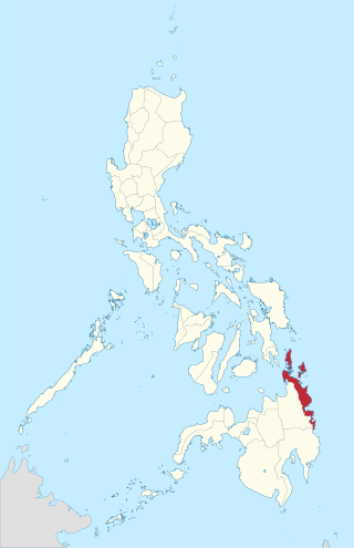
Caraga, officially the Caraga Administrative Region and designated as Region XIII, is an administrative region in the Philippines occupying the northeastern section of Mindanao. The region was created through Republic Act No. 7901 on February 23, 1995. The region comprises five provinces: Agusan del Norte, Agusan del Sur, Dinagat Islands, Surigao del Norte, and Surigao del Sur; six cities: Bayugan, Bislig, Butuan, Cabadbaran, Surigao and Tandag; 67 municipalities and 1,311 barangays. Butuan, the most urbanized city in Caraga, serves as the regional administrative center.

Claver, officially the Municipality of Claver, is a 2nd class municipality in the province of Surigao del Norte, Philippines. According to the 2020 census, it has a population of 36,033 people.

Loreto, officially the Municipality of Loreto, is a 4th class municipality in the province of Dinagat Islands, Philippines. According to the 2020 census, it has a population of 9,690 people.

Surigao City, officially the City of Surigao, is a 1st class component city and capital of the province of Surigao del Norte, Philippines. According to the 2020 census, it has a population of 171,107 people.

Dinagat Islands, officially the Province of Dinagat Islands, is an island province in the Caraga region of the Philippines, located on the south side of Leyte Gulf. The island of Leyte is to its west, across Surigao Strait, and Mindanao is to its south. Its main island, Dinagat, is about 60 kilometres (37 mi) from north to south.
The Surigaonon people are an ethnolinguistic group who inhabited on the eastern coastal plain of Mindanao, particularly the provinces of Surigao del Norte, Surigao del Sur and Dinagat Islands. They are also present in the provinces of Agusan del Norte, Agusan del Sur, and in Davao Oriental. They are part of the Bisaya people, who constitute the largest Filipino ethnolinguistic group in the country.

24 Oras Northern Mindanao, formerly Testigo Northern Mindanao, is a Philippine television news broadcasting program broadcast by GMA Northern Mindanao. Originally anchored by Kenneth Ragpala, it premiered on February 5, 2013 replacing Isyu Karon. Joe Legaspina served as the final anchor.

The Philippine Science High School - Caraga Region Campus (PSHS-CRC) is the 13th campus of the Philippine Science High School System located at Brgy. Ampayon, Butuan. The school admits and grants scholarships to students who are gifted in science and mathematics. It caters to scholars from Caraga which covers the provinces of Surigao del Norte, Surigao del Sur, Dinagat Islands, Agusan del Norte, and Agusan del Sur. Some scholars come from nearby provinces of Region X. A few from other regions of the country. The PSHS-CRC formally opened in June 2014.
Surigao was a province of the Philippines. Originally a Spanish-era district, became a chartered province on May 15, 1901. The province was dissolved on 1960.

The geology of Sudan formed primarily in the Precambrian, as igneous and metamorphic crystalline basement rock. Ancient terranes and inliers were intruded with granites, granitoids as well as volcanic rocks. Units of all types were deformed, reactivated, intruded and metamorphosed during the Proterozoic Pan-African orogeny. Dramatic sheet flow erosion prevented almost any sedimentary rocks from forming during the Paleozoic and Mesozoic. From the Mesozoic into the Cenozoic the formation of the Red Sea depression and complex faulting led to massive sediment deposition in some locations and regional volcanism. Sudan has petroleum, chromite, salt, gold, limestone and other natural resources.

The geology of Bosnia & Herzegovina is the study of rocks, minerals, water, landforms and geologic history in the country. The oldest rocks exposed at or near the surface date to the Paleozoic and the Precambrian geologic history of the region remains poorly understood. Complex assemblages of flysch, ophiolite, mélange and igneous plutons together with thick sedimentary units are a defining characteristic of the Dinaric Alps, also known as the Dinaride Mountains, which dominate much of the country's landscape.
Mount Diwata, colloquially nicknamed as Diwalwal, is a remote 1,261-metre (4,137 ft) high range of volcanic mountain and biodiversity area in Davao Region in the eastern part of Mindanao island of Philippines. Rich in gold and copper ores and mines, it is spread across the 3 municipalities: (a) Monkayo in the province of Davao de Oro; as well as (b) Cateel and (c) Boston in the province of Davao Oriental. Laguna Copperplate Inscription, the oldest written document in Philippines dated to 900 CE, refers to Mount Diwata.

The geology of California is highly complex, with numerous mountain ranges, substantial faulting and tectonic activity, rich natural resources and a history of both ancient and comparatively recent intense geological activity. The area formed as a series of small island arcs, deep-ocean sediments and mafic oceanic crust accreted to the western edge of North America, producing a series of deep basins and high mountain ranges.

The COVID-19 pandemic in Caraga is part of the worldwide pandemic of coronavirus disease 2019 caused by severe acute respiratory syndrome coronavirus 2. The virus reached Caraga on April 6, 2020, when the first case of the disease was confirmed in Butuan. The region was the last of the Philippines' 17 regions to confirm their first case. All provinces now have at least one confirmed COVID-19 case.
The Tago River is a stream located in Sibagat, Agusan del Sur, and the municipalities of San Miguel and Tago, Surigao del Sur, Caraga Region, in northeastern Mindanao, in southern Philippines.

