New Sweden was a Swedish colony along the lower reaches of the Delaware River in what is now the United States from 1638 to 1655, established during the Thirty Years' War when Sweden was a great military power. New Sweden formed part of the Swedish efforts to colonize the Americas. Settlements were established on both sides of the Delaware Valley in the region of Delaware, New Jersey, Maryland, and Pennsylvania, often in places where Swedish traders had been visiting since about 1610. Fort Christina in Wilmington, Delaware, was the first settlement, named after the reigning Swedish monarch. The settlers were Swedes, Finns, and a number of Dutch. New Sweden was conquered by the Dutch Republic in 1655 during the Second Northern War and incorporated into the Dutch colony of New Netherland.

Tinicum Township, also known as Tinicum Island or The Island, is a township in Delaware County, Pennsylvania, United States. The population was 4,091 at the 2010 census, down from 4,353 at the 2000 census. Included within the township's boundaries are the communities of Essington and Lester.

Tulpehocken Creek is a 39.5-mile-long (63.6 km) tributary of the Schuylkill River in southeastern Pennsylvania in the United States, and during the American Canal Age, once provided nearly half the length of the Union Canal linking the port of Philadelphia, the largest American city and the other communities of Delaware Valley with the Susquehanna basin and the Pennsylvania Canal System connecting the Eastern seaboard to Lake Erie and the new settlements of the Northwest Territory via the Allegheny}, Monongahela. and Ohio Rivers at Pittsburgh.

Fort Nya Elfsborg was a fortification and settlement established as a part of New Sweden. Built in 1643 and named after the Älvsborg Fortress off Gothenburg, Fort Nya Elfsborg was located on the New Jersey side of the Delaware River, between present day Salem and Alloway Creek.

Cobbs Creek is an 11.8-mile-long (19.0 km) tributary of Darby Creek in Delaware County, Pennsylvania, in the United States. It forms an approximate border between Montgomery County and Delaware County. After Cobbs Creek passes underneath Township Line Road, it forms the border between Philadelphia County and Delaware County. It runs directly through the two sides of Mount Moriah Cemetery which spans the border of Southwest Philadelphia and Yeadon, Pennsylvania. It later joins Darby Creek before flowing into the Delaware River.

Frankford Creek is a minor tributary of the Delaware River in southeast Pennsylvania. It derived its name from the nearby town of Frankford, Philadelphia County. The stream originates as Tookany Creek at Hill Crest in Cheltenham Township and meanders eastward, then southeastward, throughout Cheltenham Township, until a sharp bend near the Philadelphia border at Lawncrest, where the place names Toxony and Tookany were used in historic times; the stream is still known as Tookany Creek in this region, where it flows southwest. Turning south into Philadelphia at the crotch of Philadelphia's V-shaped border, the creek is called Tacony Creek; from here southward, it is considered the informal boundary separating Northeast Philadelphia from the rest of the city. The Philadelphia neighborhoods of Olney and Feltonville lie on the western side of the stream in this area while Northwood, Lawncrest, Summerdale, and Frankford lie on the eastern side. It continues to be called the Tacony at least until the smaller Wingohocking Creek merges with it in Juniata Park, within the city-owned golf course. Beyond Castor Avenue it is known as Frankford Creek until the stream's confluence with the Delaware River in the Bridesburg neighborhood of Philadelphia. The section of stream known as Frankford Creek is 3.1 miles (5.0 km) long, and the upstream section known as Tacony Creek, from Hill Crest, is 11.1 miles (17.9 km) long.

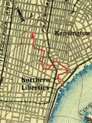
The Cohocksink Creek was formerly a stream running between what are now the Philadelphia neighborhoods of Northern Liberties and Kensington. It was a tributary of the Delaware River. Its name, spelled various ways, is said to come from a Lenape word for "pine lands". Alternate names included Stacey's Creek. The creek arose at the confluence of two smaller streams in a pond around the present-day intersection of Sixth and Thompson streets. For centuries, Cohocksink Creek has often been confused with Cohoquinoque Creek, a culverted stream about a mile to the south.

Bartram's Garden is a 50-acre public garden and National Historic Landmark in Southwest Philadelphia, Pennsylvania, situated on the banks of the Tidal Schuylkill River. Founded in 1728 by botanist John Bartram (1699–1777), it is the oldest botanical garden to survive in North America. The Garden is operated by the non-profit John Bartram Association in coordination with Philadelphia Parks and Recreation.
The John Heinz National Wildlife Refuge at Tinicum is a 1000-acre (4.05 km2) National Wildlife Refuge in Philadelphia and Tinicum Township, Pennsylvania. Adjacent to Philadelphia International Airport, the refuge is designed to the largest remaining freshwater tidal marsh in Pennsylvania. Established in 1972 as the Tinicum National Environmental Center, it was renamed in 1991 after the late H. John Heinz III, who helped preserve Tinicum Marsh.

Southwest Philadelphia is a section of Philadelphia, Pennsylvania, United States. The section can be described as extending from the western side of the Schuylkill River to the city line, with the SEPTA. The northern border is defined by the Philadelphia City Planning Commission as east from the city line along Baltimore Avenue moving south along 51st Street to Springfield Ave. It follows the train tracks until 49th Street. From 49th and Kingsessing Ave the line moves east along Kingsessing Ave. The line then moves south along 46th St to Paschall Ave where it jogs to join Grays Ferry where the line runs to the Schuylkill River.

Elmwood Park, also known simply as Elmwood, is a neighborhood in the Southwest section of Philadelphia, Pennsylvania, United States. It borders the city line with Delaware County at Cobbs Creek, and extends to the Schuylkill River. The Eastwick neighborhood borders it to the southwest, and Kingsessing borders it on the northeast.

Pennsylvania Route 291 is an east–west route in Pennsylvania that runs from U.S. Route 13 and US 13 Business in Trainer, Delaware County, east to Interstate 76 (I-76) in South Philadelphia near the Walt Whitman Bridge and the South Philadelphia Sports Complex. Except for a short 1-mile (1.6 km) section between the western terminus and the Chester/Trainer line, PA 291 is mostly a four-lane highway. From the western terminus to the eastern part of Chester, the route has a concurrency with US 13. It runs parallel to the Delaware River for much of the route. The route passes through industrial areas near the river in Delaware County, serving Chester, Eddystone, Essington, and Lester. PA 291 enters Philadelphia near the Philadelphia International Airport, at which point it has an interchange with I-95. The route crosses the Schuylkill River on the George C. Platt Memorial Bridge and continues along Penrose Avenue to I-76. It has been designated the Industrial Heritage Highway.

Fort Beversreede was a Dutch-built palisaded factorij located near the confluence of the Schuylkill River and the Delaware River. It was an outpost of the colony of New Netherland, which was centered on its capital, New Amsterdam (Manhattan), on the North River.

New Netherland, or Nieuw-Nederland in Dutch, was the 17th century colony of the Republic of the Seven United Netherlands on the northeastern coast of North America. The claimed territory included southern Cape Cod to parts of the Delmarva Peninsula. Settled areas are now part of the Mid-Atlantic states of New York, New Jersey, Connecticut, Delaware and Pennsylvania. Its capital, New Amsterdam, was located at the southern tip of the island of Manhattan on Upper New York Bay.

Great Minquas Path was a 17th-century trade route that ran through southeastern Pennsylvania from the Susquehanna River, near Conestoga, to the Schuylkill River, opposite Philadelphia. The 80-mile (130 km) east-west trail was the primary route for fur trading with the Minquas people. Dutch, Swedish and English settlers fought one another for control of it.
Pickering Creek is a 15.3-mile-long (24.6 km) tributary of the Schuylkill River in Chester County, Pennsylvania.

Dock Creek was a stream draining much of what is now the eastern half of Center City, Philadelphia. It was a tributary of the Delaware River. By 1820, the entire creek had been covered and converted to a sewer. The present-day Dock Street follows the lower course of the stream.


