Mirab Imi

Last updated
West Imi
Ethiopia adm location map.svg
Red pog.svg
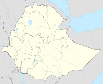
West Imi
Location within Ethiopia
Coordinates: 6°27′N42°08′E / 6.450°N 42.133°E / 6.450; 42.133
Country Ethiopia
Region Somali
Zone Afder
Elevation
442 m (1,450 ft)
Population
  City48,104
   Urban
7,897
Time zone UTC+3 (EAT)

West Imi (Somali : Iimeey Galbeed) is one of the Districts of Afder Zone in the Somali Region of Ethiopia. It is named for the historically significant village, Imi. Part of the Afder Zone, West Imi is bordered on the south by [ Elekere, on the west by Raytu district Oromia Region, on the north by the Nogob Zone, and on the northeast by the Shebelle River which separates it from the Shabelle Zone.The major village in Mirab Imi is BUULAA and jiiq and Gabriile and kiliwey it is settled by gadsan clan specially ree (ABOKOR).

The average elevation in this woreda is 459 meters above sea level. [1] As of 2008, West Imi has no all-weather gravel road nor any community roads; about 14.2% of the total population has access to drinking water. [2]

The Shebelle River burst its banks in November 2008, and affected 17 kebeles in West Imi, damaging crops on 3,200 hectares of farmland. [3]

Demographics

Based on the 2007 Census conducted by the Central Statistical Agency of Ethiopia (CSA), this woreda has a total population of 48,104, of whom 27,067 are men and 21,037 women. While 7,897 or 16.42% are urban inhabitants, a further 10,811 or 22.47% are pastoralists. 98.72% of the population said they were Muslim, This woreda is mainly inhabited karanle hawiye of Somali . [4]

The 1997 national census reported a total population for this woreda of 48,675, of whom 20,627 were men and 18,048 were women; 1,197 or 3.1% of its population were urban dwellers. (This total also includes an estimate for the inhabitants of 32 rural villages, which were not counted; they were estimated to have 3,436 inhabitants, of whom 1,847 were men and 1,589 women.)

Notes

  1. Hailu Ejara Kene, Baseline Survey of 55 Weredas of PCDP Phase II, Part I Archived 2011-07-20 at the Wayback Machine (Addis Ababa: August 2008), Annex 1 (accessed 23 March 2009)
  2. Hailu Ejara Kene, Baseline Survey, Annexes 16, 17
  3. "Ethiopia: Thousands displaced by floods in Somali region", IRIN (last accessed 8 December 2008)
  4. Census 2007 Tables: Somali Region Archived 2012-11-14 at the Wayback Machine , Tables 2.1, 2.4, 3.1 and 3.4.

Related Research Articles

Kelafo is a woreda in the Somali Region of Ethiopia. Part of the Gode Zone, Kelafo is bordered on the south by the Somalia, on the west by Adadle, on the northwest by Gode, on the northeast by the Korahe Zone, and on the east by Mustahil. The Shebelle River flows through this woreda. The major town in the Kelafo district is Kelafo.

Mustahil is a woreda in the Somali Region of Ethiopia. Part of the Gode Zone, Mustahil is bordered on the south by Somalia, on the west by Kelafo, on the north by the Korahe Zone, and on the east by Ferfer. The Shebelle River is flowing through this woreda. The major town in this woreda is Mustahīl.

Afambo is a woreda in Afar Region, Ethiopia. It is named after Lake Afambo, located at the border of this woreda with Asayita, near the international border with Djibouti. Part of the Administrative Zone 1, Afambo is bordered on the south by the Somali Region, on the west by Dubti, on the north by Asayita, and on the east by Djibouti. The largest town in this woreda is Afambo.

Konnaba, in English written as Koneba, is a woreda in Afar Region, Ethiopia. A triangle-shaped district in the Administrative Zone 2, Konaba is located near the base of the eastern escarpment of the Ethiopian Highlands, and is bordered on the west by the Tigray Region, on the north by Dallol, and on the east by Berhale. Koneba woreda has 7 kebeles names by koneba ena balbal, adad ena farasdage, guqa ena kedahara, uruc ena ede gacnu, fisho, wacdes and alceena. Koneba is the historical woreda in afar it has Gold.

Telalak is one of the Districts of Ethiopia, or woredas, in the Afar Region of Ethiopia. Part of the Administrative Zone 5, Telalak is located near the base of the eastern escarpment of the Ethiopian highlands, and bordered on the south by Dewe, on the west by the Amhara Region, on the north by the Administrative Zone 1, and on the east by the Administrative Zone 3. The largest settlement in this woreda is Namelafen.

Ayesha is a woreda in Somali Region, Ethiopia. The northernmost woreda of the Shinile Zone, Ayesha is bordered on the south by Dembel, on the west by Shinile, on the north by Djibouti, on the east by Somaliland, and on the southeast by the Jijiga Zone. Towns in Ayesha include Ayesha, Dewele, Lasarat and Mermedebis.

Erer is a woreda in Somali Region, Ethiopia. Part of the Shinile Zone, Erer is bordered on the south by Dire Dawa and Oromia Region, on the southwest by Afdem, on the northwest by the Afar Region, and on the east by Shinile.

Shinile is a woreda in Somali Region, Ethiopia. Part of the Sitti Zone, Shinile is bordered on the south by Dire Dawa, on the west by Erer, on the north by the Afar Region, on the east by Ayesha, and on the southeast by Dembel and Jijiga Zone. Towns in Shinile include Adigale, Harewa, Milo, and Shinile; villages include Jaldessa, Marmaarsa, and Toome.

Jijiga is one of the woredas in the Somali Region of Ethiopia. Part of the Jijiga Zone, Jijiga is bordered on the south by Kebri Beyah, on the southwest by Gursum, on the southeast by Ajersagora, on the northwest by the Shinile Zone, and on the north by Awbare. Towns and cities in this woreda include Jijiga.

Fiq is a woreda in Somali Region, Ethiopia, named after its major town, Fiq. Part of the Fiq Zone, Fiq is bordered on the south by Hamero, on the western Qubi ,on the west by Mayumuluka, on the north by the Jijiga Zone, on the east by the Degehabur Zone, and on the southeast by Segeg; the woreda's western boundary is defined by the Erer River.

Dihun is a woreda in Somali Region, Ethiopia. Part of the Nogob Zone, Dihun is bordered on the south by the Gode Zone, on the west by the Shebelle River which separates it from Salahad, on the northwest by Hamero, on the northeast by Segeg, and on the east by Gerbo. The major town in Dihun is Geresley.

Degehabur is a woreda in Somali Region, Ethiopia. Part of the Degehabur Zone, Degehabur is bordered on the southeast by the Gunagado and Korahe Zone, on the southwest by the Fiq Zone, on the west by Degehamedo, on the north by the Jijiga Zone, and on the east by Aware; it is frequently considered part of the Haud. The administrative center of this woreda is Degehabur.

Werder is one of the woredas in the Somali Region of Ethiopia, named after its administrative center, Werder. Part of the Werder Zone, Werder is bordered on the southwest by the Korahe Zone, on the north by Danot, and on the east by Geladin.

Kebri Dahar is a woreda in the Somali Region of Ethiopia. Part of the Korahe Zone, Kebri Dahar is bordered on the south by Debeweyin, on the west by the Gode Zone, on the northwest by Shekosh, on the north by the Degehabur Zone, on the east by the Werder Zone, and on the southeast by Shilavo. The largest city in Kebri Dahar is Kebri Dahar. The population of Kebri Dahar is 936,000.

Debeweyin is one of the woredas in the Somali Region of Ethiopia. Part of the Korahe Zone, Debeweyin is bordered on the southwest by the Gode Zone, on the north by Kebri Dahar, and on the east by Shilavo. The major town in Debeweyin is Har Ad.

Gode (Godey) is a woreda in the Somali Region of Ethiopia, named after its major town, Gode. Part of the Gode Zone, Gode is bordered on the south by the Shebelle River which separates it from Adadle, on the northwest by Imiberi, on the north by Danan, on the northeast by the Korahe Zone, and on the southeast by Kelafo.

Ferfer is a woreda in the Somali Region of Ethiopia, named after its major town, Ferfer. Part of the Gode Zone, Ferfer is bordered on the west by Mustahil, on the north by the Korahe Zone, and on the east and south by the Provisional Administrative Line with Somalia. The Shebelle River flows through this woreda.

Elekere or Serer is one of the woredas in the Somali Region of Ethiopia. Part of the Afder Zone, Elekere is bordered on the southeast by Afder, on the southwest by Cherti, on the west by Goro Bekeksa, on the north by Mirab Imi, and on the east by Gode Zone. The major town in Elekere is El Kere.

Guradamole is one of the woredas in the Somali Region of Ethiopia. Part of the wacdi jamac nuur cilmi, Guradamole is bounded on the south by the Ganale Dorya River which separates it from the Liben Zone, on the west by Kersa Dula, on the north by the Oromia Region, and on the east by Goro Bekeksa. Towns in this woreda include Harardubo and Kundi.

Chereti or Weyib is one of the woredas in the Somali Region of Ethiopia, named after its major town, Melka Chireti. Part of the Afder Zone, Chereti is bordered on the southwest by the Ganale Dorya River which separates it from the Liben Zone, on the west by Goro Bekeksa, on the north by Elekere, on the east by Afder, and on the southeast by Dolobay.