The average elevation in this woreda is 358 meters above sea level.[1]As of 2008[update], Gode has 125 kilometers of all-weather gravel road and 630 kilometers of community roads; about 3.53% of the total population has access to drinking water.[2]
Reports of the parts of the Somali Region affected by flash floods in 2006 use the DPPA's description of the Gode woreda. Gode was very severely affected, and losses reported for this woreda include 10 deaths 333 hectares of cropland ruined.[3]
Demographics
Based on the 2007 Census conducted by the Central Statistical Agency of Ethiopia (CSA), this woreda has a total population of 109,718, of whom 62,102 are men and 47,616 women. While 43,234 or 39.41% are urban inhabitants, a further 30,431 or 27.74% are pastoralists. 97.85% of the population said they were Muslim.[4] This woreda is primarily inhabited by the Ogaden clan of the Somali people,[5]
The 1997 national census reported a total population for this woreda of 127,920, of whom 71,322 were men and 56,598 were women; 45,755 or 35.77% of its population were urban dwellers. (This total also includes an estimate for the inhabitants of 21 rural kebeles, which were not counted; they were estimated to have 31,059 inhabitants, of whom 16,772 were men and 14,287 women.) The largest ethnic group reported in Erer was the Somali (99.9%) and all the other ethnic groups made up 0.08% of the population.[6]
Economy
Although Gode is mainly arid, the crops grown in this woreda include maize, vegetables such as peppers, tomatoes, carrots, and fruits such as mango, papaw, guava, banana and lemon along the Shebelle. Further back from the river, sorghum and maize are cultivated using the seasonal river flooding or by digging small channels from the streams to the crop production areas; a limited amount of vegetables are produced in this area. Shortly after its founding, the Regional government established a farm of 752 ha in west Gode, located 60 kilometres from the town of Gode, in a different locality than the old Godey State Farm (now in Adadle). In the irrigation scheme the crops grown by the Regional Irrigation Bureau include maize and beans; vegetables such as onions, beetroot, carrot, cabbage and tomato; and fruits such as papaya, mango and guava.[7] Gode is estimated to have a cattle population of 352,000, 244,350 sheep, 135,000 goats, and 45,000 camels and horses combined. The ecosystem of the woreda is fragile and has been subjected to intensive grazing, intensive destruction of trees for fuel wood and construction material. The area is highly denuded and exposed to soil and wind erosion. This phenomenon of environmental deterioration has been observed even during the early 1990s.[8]
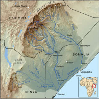
The Shebelle River begins in the highlands of Ethiopia, and then flows southeast into Somalia towards Mogadishu. Near Mogadishu, it turns sharply southwest, where it follows the coast. Below Mogadishu, the river becomes seasonal. During most years, the river dries up near the mouth of the Jubba River, while in seasons of heavy rainfall, the river actually reaches the Jubba and thus the ocean.
Shabelle is one of nine Zones of the Somali Region of Ethiopia. It was previously known as Gode, so named after its largest city, Gode. Shabelle is bordered on the west by Afder, on the north by Fiq, on the northeast by Korahe. On the south it borders the Provisional Administrative Line of Somalia along the borders of the Hirshabelle and Galmudug federal states.
Argobba is a special woreda in the Afar Region of Ethiopia. This woreda is named after the Argobba people, whose homeland lies in this district. Located on the eastern escarpment of the Ethiopian highlands, Argobba is bordered on the south, west and north by the Afar Region, and on the east by Dulecha. Settlements in this woreda include Gachine.
Kelafo is a woreda in the Somali Region of Ethiopia. Part of the Gode Zone, Kelafo is bordered on the south by the Somalia, on the west by Adadle, on the northwest by Gode, on the northeast by the Korahe Zone, and on the east by Mustahil. The Shebelle River flows through this woreda. The major town in the Kelafo district is Kelafo.
Mustahil is a woreda in the Somali Region of Ethiopia. Part of the Gode Zone, Mustahil is bordered on the south by Somalia, on the west by Kelafo, on the north by the Korahe Zone, and on the east by Ferfer. The Shebelle River is flowing through this woreda. The major town in this woreda is Mustahīl.
Afambo is a woreda in Afar Region, Ethiopia. It is named after Lake Afambo, located at the border of this woreda with Asayita, near the international border with Djibouti. Part of the Administrative Zone 1, Afambo is bordered on the south by the Somali Region, on the west by Dubti, on the north by Asayita, and on the east by Djibouti. The largest town in this woreda is Afambo.
Dubti is a woreda in Afar Region, Ethiopia. Part of the Administrative Zone 1, Dubti is bordered on the south by the Somali Region, on the southwest by Mille, on the west by Chifra, on the northwest by the Administrative Zone 4, on the north by Kori, on the northeast by Elidar, on the east by Asayita, and on the southeast by Afambo. Towns in Dubti include Dubti, Logiya, and Semera.
Ayesha is a woreda in Somali Region, Ethiopia. The northernmost woreda of the Shinile Zone, Ayesha is bordered on the south by Dembel, on the west by Shinile, on the north by Djibouti, on the east by Somaliland, and on the southeast by the Jijiga Zone. Towns in Ayesha include Ayesha, Dewele, Lasarat and Mermedebis.
Erer is a woreda in Somali Region, Ethiopia. Part of the Shinile Zone, Erer is bordered on the south by Dire Dawa and Oromia Region, on the southwest by Afdem, on the northwest by the Afar Region, and on the east by Shinile.
Shinile is a woreda in Somali Region, Ethiopia. Part of the Sitti Zone, Shinile is bordered on the south by Dire Dawa, on the west by Erer, on the north by the Afar Region, on the east by Ayesha, and on the southeast by Dembel and Jijiga Zone. Towns in Shinile include Adigale, Harewa, Milo, and Shinile; villages include Jaldessa, Marmaarsa, and Toome.
Jijiga is one of the woredas in the Somali Region of Ethiopia. Part of the Jijiga Zone, Jijiga is bordered on the south by Kebri Beyah, on the southwest by Gursum, on the southeast by Ajersagora, on the northwest by the Shinile Zone, and on the north by Awbare. Towns and cities in this woreda include Jijiga.
Kibri Bayah
Dihun is a woreda in Somali Region, Ethiopia. Part of the Nogob Zone, Dihun is bordered on the south by the Gode Zone, on the west by the Shebelle River which separates it from Salahad, on the northwest by Hamero, on the northeast by Segeg, and on the east by Gerbo. The major town in Dihun is Geresley.
Werder is one of the woredas in the Somali Region of Ethiopia, named after its administrative center, Werder. Part of the Werder Zone, Werder is bordered on the southwest by the Korahe Zone, on the north by Danot, and on the east by Geladin.
Kebri Dahar is a woreda in the Somali Region of Ethiopia. Part of the Korahe Zone, Kebri Dahar is bordered on the south by Debeweyin, on the west by the Gode Zone, on the northwest by Shekosh, on the north by the Degehabur Zone, on the east by the Werder Zone, and on the southeast by Shilavo. The largest city in Kebri Dahar is Kebri Dahar. The population of Kebri Dahar is 93000.
Ferfer is a woreda in the Somali Region of Ethiopia, named after its major town, Ferfer. Part of the Gode Zone, Ferfer is bordered on the west by Mustahil, on the north by the Korahe Zone, and on the east and south by the Provisional Administrative Line with Somalia. The Shebelle River flows through this woreda.
West Imi is one of the Districts of Afder Zone in the Somali Region of Ethiopia. It is named for the historically significant village, Imi. Part of the Afder Zone, West Imi is bordered on the south by [Elekere, on the west by Raytu district Oromia Region, on the north by the Nogob Zone, and on the northeast by the Shebelle River which separates it from the Shabelle Zone.The major village in Mirab Imi is BUULAA and jiiq and Gabriile and kiliwey it is settled by the ree Abakor ( the largest clan of gaadsan.
Bare is one of the woredas in the Somali Region of Ethiopia. Part of the Afder Zone, Bare is bordered on the south by the Provisional Administrative Line with Somalia, on the west by Dolobay, on the north by Afder, and on the east by the Gode Zone. The major town in this woreda is Bare.
Adadle is one of the woredas in the Somali Region of Ethiopia. Part of the Gode Zone, Adadle is bordered on the west by the Afder Zone, on the north by the Shebelle River which separates it from Gode, on the east by Kelafo, and on the south by Somalia.
Chereti or Weyib is one of the woredas in the Somali Region of Ethiopia, named after its major town, Melka Chireti. Part of the Afder Zone, Chereti is bordered on the southwest by the Ganale Dorya River which separates it from the Liben Zone, on the west by Goro Bekeksa, on the north by Elekere, on the east by Afder, and on the southeast by Dolobay.
This page is based on this Wikipedia article Text is available under the CC BY-SA 4.0 license; additional terms may apply. Images, videos and audio are available under their respective licenses.
