Dolo Odo

Last updated

Dolo Addo or Dolo Ado or Dollo Ado (Somali : Dooloow) is one of the woredas in the Somali Region of Ethiopia. Part of the Liben Zone, Dolo Ado is located in the angle formed by the confluence of the Ganale Dorya with the Dawa River, and bordered to the northwest by Filtu, on the northeast by Afder Zone, on the southeast by Somalia, and on the south by Kenya. Towns in Dollo Ado include Koole, Dolo and Suftu. It is home to Garimarro and Degodia who are living in dollo ado

Contents

The altitude of this woreda ranges from 200 to 1000 meters above sea level. Other rivers in this woreda include the Mena. As of 2008, Dolo Ado has 120 kilometers of all-weather gravel road and 540 kilometers of community roads; about 58.8% of the total population has access to drinking water. [1]

History

Dolo Ado refugee camp, 2011 Dolo Odo camp, Ethiopia (5937172394).jpg
Dolo Ado refugee camp, 2011

Irrigation agriculture was introduced to the riverine inhabitants of this woreda by the Relief and Rehabilitation Commission (RRC) in the late 1970s. While the RRC encouraged this trend with the introduction of three irrigation pumps at selected points, a major impetus were local people who had fled to refugee camps in Somalia during the Ethiopian-Somali war, where they had the opportunity to acquire the basic skills and know-how of irrigation agriculture while participating in irrigation schemes in the Lower Juba River, and returning to Dolo Ado where they put their knowledge to use. These new skills have led to the arable lands on the dry riverbed and the flood plains, which used to be dry season grazing and farming areas for the Garimarro, Masarre, Degodia,and ujejen also becoming attractive to groups of newcomers, which has led to strife between the groups. Ahmed Ali Gedi has identified nine conflicts between Degodia sub-clans, who have traditionally had peaceful relations, which resulted in one or more casualties between 1997 and 2005. Furthermore, as the land between the flood plains and riverbanks, which was primarily basin woodlands and dry season pasturage, has been converted to commercial farming, this has caused deforestation and displacement of the original inhabitants. [2]

In June, 2005, Both the Dawa and Ganale Dorya rivers overflowed their banks and flooded Dolo Ado. According to reports, six people died, irrigation pumps were swept away, and hundreds of livestock were drowned. [3]

In November 2008, Dolo Ado was one of the woredas heavily affected by the Ganale Dorya flooding. At least 10,740 people reportedly were displaced, and roads from Dolo to Filtu and Negele Boran were blocked. [4]

In 2012, the Commercial Bank of Ethiopia was established in the town of Dolo Ado. [5]

Demographics

There has been a 30% population increase in 1994 when compared with the recorded population of 4,520 in the 1984 census, and the forecasted figure for 2005 indicates that there would be a 415% increase by the year 2005. Population experts and local leaders attribute this population boom to a number of factors of which the primary one is the large returnee population from neighboring Somalia. [6] The 1997 national census reported a total population for this woreda of 13,412, of whom 7,678 were men and 64,734 were women; 3,301 or 8.39% of its population were urban dwellers. The largest ethnic group reported in Dolo Ado was the Somali 13,987 (96.8%). [7] A study in 2005 categorized the woreda population as follows: 50% of the people are identified as agro-pastoralists, 30% as transhumant pastoralists, 15% as urban and 5% as sedentary farmers. [8] Based on the 2007 Census conducted by the Central Statistical Agency of Ethiopia (CSA), this woreda has a total population of 111,511, of whom 60,778 are men and 50,733 women. While 37,404 or 33.54% are urban inhabitants, a further 33,869 or 30.37% are pastoralists. 95.69% of the population said they were Muslim. [9]

This woreda is primarily inhabited by Clans of Garimarro, Masarre and Degodia

Refugee camps

Ethiopia Somali region relief location map.svg
Red pog.svg
Bo
Red pog.svg
Bu
Red pog.svg
Hi
Red pog.svg
Ko
Red pog.svg
Me
Refugee camps in Dollo Ado. (Map shows the whole Somali Region.)
Bo=Bokolmanyio, Bu=Buramino, Hi=Hilaweyn, Ko=Kobe, Me=Melkadida

There are five refugee camps in the Dollo Ado region housing 219,284 refugees from Somalia: [10] [11]

The main areas of origin of these refugees are Gedo (53%), Bay (28%) and Bakool (12%) and the main ethnicities are Rahanweyn (58%), Marehan (21%) and Hawiye (9%). [12]

Between June and November 2011, a measles outbreak occurred in a refugee complex in Dolo Ado. Many of the refugees were unvaccinated. [13]

In 2017, with the support of UNHCR, a Dedebit MFI was created in the refugee camp of Dolo Ado. [5]

Agriculture

A sample enumeration performed by the CSA in 2001 interviewed 8,437 farmers in this woreda, who held an average of 0.56 hectares of land. Of the 4,708 hectares of private land surveyed, 27.82% was under cultivation, 7.86% was pasture, 56.78% fallow, 1.06% woodland, and 3.31% was devoted to other uses; the area in woodland is missing. For the land surveyed in this woreda, 24.04% is planted in cereals like maize and sorghum, 1.98% in pulses, 0.53% in root crops, and 0.85% vegetables. Permanent crops included 146.06 hectares planted in fruit trees. 41.2% of the farmers both raise crops and livestock, while 3.35% only grow crops and 55.45% only raise livestock. Land tenure in this woreda was distributed amongst 85.89% owning their land, 3.1% renting, and the remaining 11% holding their land under other forms of tenure. [14]

Related Research Articles

<span class="mw-page-title-main">Somali Region</span> Regional state in eastern Ethiopia

The Somali Region, also known as Soomaali Galbeed and officially the Somali Regional State, is a regional state in eastern Ethiopia. Its territory is the largest after Oromia Region. The regional state borders the Ethiopian regions of Afar and Oromia and the chartered city Dire Dawa to the west, as well as Djibouti to the north, Somalia to the northeast, east and south; and Kenya to the southwest.

<span class="mw-page-title-main">Liben Zone</span> Zone in Somali Region of Ethiopia

Liben is a zone in Somali Region of Ethiopia. Liben is bordered on the south by Kenya, on the northwest by the Oromia Region, on the northeast by Afder, and on the southeast by Somalia's federal state of Jubaland. Towns in Liben zone include Filtu, Gof Bokolmayo, Deka Suftu, and Dolo. Borena National Park covers the southwestern portion of the zone.

Mustahil is a woreda in the Somali Region of Ethiopia. Part of the Gode Zone, Mustahil is bordered on the south by Somalia, on the west by Kelafo, on the north by the Korahe Zone, and on the east by Ferfer. The Shebelle River is flowing through this woreda. The major town in this woreda is Mustahīl.

Amibara is a woreda in Afar Region, Ethiopia. Part of the Administrative Zone 3, Amibara is bordered on the south by Awash Fentale, on the west by the Awash River which separates it from Dulecha, on the northwest by the Administrative Zone 5, on the north by Gewane, on the east by the Somali Region, and on the southeast by Oromia Region. Towns in Amibara include Awash Arba, Awash Sheleko, Melka Sedi and Melka Were.

Awash Fentale is a woreda in Afar Region, Ethiopia. Part of the Administrative Zone 3, Awash Fentale is bordered on the south by the Oromia Region, on the west by the Amhara Region, on the north by Dulecha, and on the east by Amibara. Towns in Awash Fentale include Awash Sebat Kilo and Sabure.

Ayesha is a woreda in Somali Region, Ethiopia. The northernmost woreda of the Shinile Zone, Ayesha is bordered on the south by Dembel, on the west by Shinile, on the north by Djibouti, on the east by Somaliland, and on the southeast by the Jijiga Zone. Towns in Ayesha include Ayesha, Dewele, Lasarat and Mermedebis.

Erer is a woreda in Somali Region, Ethiopia. Part of the Shinile Zone, Erer is bordered on the south by Dire Dawa and Oromia Region, on the southwest by Afdem, on the northwest by the Afar Region, and on the east by Shinile.

Shinile is a woreda in Somali Region, Ethiopia. Part of the Sitti Zone, Shinile is bordered on the south by Dire Dawa, on the west by Erer, on the north by the Afar Region, on the east by Ayesha, and on the southeast by Dembel and Jijiga Zone. Towns in Shinile include Adigale, Harewa, Milo, and Shinile; villages include Jaldessa, Marmaarsa, Toome

Awbare, officially known as Teferi Ber, is one of the woredas of the Fafan Zone in the Somali Region of Ethiopia. Awbare is bordered on the southwest by Jijiga, on the west by the Sitti Zone, on the east by Somaliland, and on the southeast by Kebri Beyah. Cities and towns in the Awbare district include Awbare, Awbube, Sheder, Lefe Isa, Derwernache, Gogti, Jaare and Heregel.

Kibri Bayah

Dolobay is one of the woredas in the Somali Region of Ethiopia. Part of the Afder Zone, Dolobay is bordered on the south by the Provisional Administrative Line with Somalia, on the west by the Ganale Dorya River which separates it from the Liben Zone, on the northwest by Cherti, on the north by Afder, and on the east by Bare. The major town in Dolobay is Weldiya.

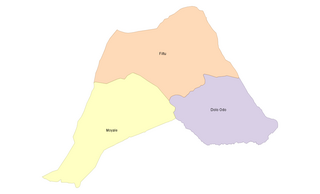
Filtu is one of the woredas in the Somali Region of Ethiopia. Part of the Liben Zone, Filtu is bordered on the south by the Dawa River which separates it from Moyale and Udet, on the west by the Oromia Region, on the north and east by the Ganale Dorya River which separates it from the Afder Zone, and on the southeast by Dolo Odo. The major town of this woreda is Filtu.

Moyale is a district in the Somali Region of Ethiopia. Located at the extreme southwest corner of the Dhawa Zone, Moyale is bounded on the south by Kenya, on the west by the Oromia Region, on the north by Udet, and on the northeast by the Dawa, which separates Moyale from Filtu. The southernmost point of this woreda is the southernmost point of Ethiopia. Towns in this woreda include Chelago.

Guradamole is one of the woredas in the Somali Region of Ethiopia. Part of the wacdi jamac nuur cilmi, Guradamole is bounded on the south by the Ganale Dorya River which separates it from the Liben Zone, on the west by Kersa Dula, on the north by the Oromia Region, and on the east by Goro Bekeksa. Towns in this woreda include Harardubo and Kundi.

Guradamole is one of the woredas in the Somalia Region of Ethiopia. Part of the Liben Zone, Guradamole is bordered on the south by the Ganale Dorya River which separates it from the Liben Zone, on the southwest by Meda Welabu, on the west by Mennana Harena Buluk, on the northwest by Berbere, on the northeast by the Mena River and on the southeast by the Somali Region. The administrative center of the woreda is Liben Zone.

Liben is one of the woredas in the Oromia Region of Ethiopia. Part of the East Borana Zone, Liben is bordered on the south by the Dawa River which separates it from the Borena Zone, on the west by Odo Shakiso, on the northwest by Adolana Wadera, on the north by the Ganale Dorya River which separates it from the Bale Zone, and on the east by the Somali Region. The map of the Oromia Region published by Disaster Prevention and Disaster Agency shows that this woreda is part of the Guji Zone, and that the eastern part has been transferred to the Somali Region to create the Liben woreda of that region. The town of Negele Boran was separated from Liben woreda and is separate woreda now.

Filtu is the capital city of '"Liben Zone"' Filtu(also known as Gindiyeer) is a town in southern Ethiopia. Located in the Liben Zone of the Somali Region, it has a latitude and longitude of 4°58′N40°23′E with an elevation of 1252 meters above sea level. It is the administrative center of Filtu woreda. During the Italian occupation, a road 115 kilometers in length to Negele Boran was maintained but not paved.

Udet is one of the woredas in the Somali Region of Ethiopia. Part of the Dhawa Zone, Udet is bordered on the south by Moyale, on the west by Liben, Oromia, and on the northeast by the Ganale Dorya River which separates it from Meda Welabu.

<span class="mw-page-title-main">Daroor (woreda)</span> Place in Somali, Ethiopia

Daroor is a town in the Misraq Gashamo woreda, in the Somali Region of Ethiopia. It is frequently considered part of the Haud. It is approximately 30 km south of the border with Somaliland.

Bokolmayo is one of the 93 districts in the Somali Region of Ethiopia. The district is located in Liben Zone and found in the middle of Filtu, and Dolo Odo, the biggest town of the Liben Zone. Bokolmayo is the district that host the most refugees in Ethiopia -- nearly 200,000. These refugees are Somalis that fled from the civil war in Somalia around early 2009. There are five refugee camps in the Liben zone, three of which are found in Bokolmayo. These refugee camps include:

  1. Bokolmayo refugee camp
  2. Malkadida refugee camp
  3. Kobe refugee camp

References

  1. Mr,leeje, Baseline Survey of 55 Weredas of PCDP Phase II, Part I Archived July 20, 2011, at the Wayback Machine (dolloado: August 2021),
  2. Ahmed Ali Gedi, Herder-Farmer Conflicts in the Dawa-Ganale River Basin Area [ permanent dead link ], p. 33, 44, 48
  3. "Relief Bulletin: 13 June 2005", UN-OCHA-Ethiopia (accessed 26 February 2009)
  4. "Ethiopia: Thousands displaced by floods in Somali region", IRIN (last accessed 8 December 2008)
  5. 1 2 reliefweb.int (2020-06-30). "Financial Services Market Assessment: Dollo Ado and Bokolmayo Refugee Camps Somali Regional State, Ethiopia" . Retrieved 2023-03-12.
  6. Ahmed Ali Gedi, Herder-Farmer Conflicts, p. 37
  7. 1994 Population and Housing Census of Ethiopia: Results for Somali Region, Vol. 1 Archived November 19, 2008, at the Wayback Machine Tables 2.1, 2.12 (accessed 10 January 2009). The results of the 1994 census in the Somali Region were not satisfactory, so the census was repeated in 1997.
  8. Ahmed Ali Gedi, Herder-Farmer Conflicts, p. 27
  9. Census 2007 Tables: Somali Region Archived November 14, 2012, at the Wayback Machine , Tables 2.1, 2.4, 3.1 and 3.4.
  10. "Refugees in the Horn of Africa: Somali Displacement Crisis - - Dollo Ado". data.unhcr.org. Archived from the original on 25 August 2016. Retrieved 22 May 2022.
  11. 1 2 3 4 5 6 "Situation Horn of Africa Somalia Situation". data2.unhcr.org. 2018-08-31. Retrieved 2019-06-04.
  12. "Sub-Office Melkadida Refugee Camps Population [download link]". Archived from the original on 2016-09-19. Retrieved 2016-08-14.
  13. PubMed (2014-08-12). "Measles outbreak response among adolescent and adult Somali refugees displaced by famine in Kenya and Ethiopia, 2011" . Retrieved 2023-03-12.
  14. http://www.csa.gov.et/surveys/Agricultural_Sample_Enumeration_2001/Agricultural_Sample_Enumeration_2001 [ permanent dead link ]

4°25′N41°25′E / 4.417°N 41.417°E / 4.417; 41.417