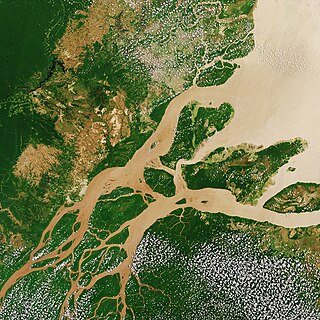
The Amazon River in South America is the largest river by discharge volume of water in the world, and the longest or second-longest river system in the world, a title which is disputed with the Nile.
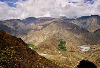
The Marañón River is the principal or mainstem source of the Amazon River, arising about 160 km to the northeast of Lima, Peru, and flowing northwest across plateaus 3,650 m high, it runs through a deeply eroded Andean valley, along the eastern base of the Cordillera of the Andes, as far as 5° 36′ southern latitude; from where it makes a great bend to the northeast, and cuts through the jungle Ande in its midcourse, until at the Pongo de Manseriche it flows into the flat Amazon basin. Although historically, the term "Marañón River" often was applied to the river all the way to the Atlantic Ocean, nowadays the Marañón River is generally thought to end at the confluence with the Ucayali River, after which most cartographers label the ensuing waterway the Amazon River.

The Nile is a major north-flowing river in northeastern Africa. It flows into the Mediterranean Sea. The Nile is the longest river in Africa. It has historically been considered the longest river in the world, though this has been contested by research suggesting that the Amazon River is slightly longer. Of the world's major rivers, the Nile is one of the smallest, as measured by annual flow in cubic metres of water. About 6,650 km (4,130 mi) long, its drainage basin covers eleven countries: the Democratic Republic of the Congo, Tanzania, Burundi, Rwanda, Uganda, Kenya, Ethiopia, Eritrea, South Sudan, Sudan, and Egypt. In particular, the Nile is the primary water source of Egypt, Sudan and South Sudan. The Nile is an important economic driver supporting agriculture and fishing.

The Ucayali River is the main headstream of the Amazon River. It rises about 110 km (68 mi) north of Lake Titicaca, in the Arequipa region of Peru and becomes the Amazon at the confluence of the Marañón close to Nauta city. The city of Pucallpa is located on the banks of the Ucayali.

Lake Itasca is a small glacial lake, approximately 1.8 square miles in area. It is located in Itasca State Park, in south-eastern Clearwater County, in the Headwaters area of north-central Minnesota, and is notable for being the headwater of the Mississippi River. It has an average depth of 20 to 35 feet and is 1,475 feet (450 m) above sea level.

The headwater of a river or stream is the point on each of its tributaries upstream from its mouth/estuary into a lake/sea or its confluence with another river. Each headwater is considered one of the river's sources, as it is the place where surface runoffs from rainwater, meltwater and/or spring water begin accumulating into a more substantial and consistent flow that becomes a first-order tributary of that river. The tributary with the longest course downstream of the headwaters is regarded as the main stem.

Arequipa is a department and region in southwestern Peru. It is the sixth largest department in Peru, after Puno, Cuzco, Madre de Dios, Ucayali, and Loreto, its sixth most populous department, and its eleventh least densely populated department. It is bordered by the departments of Ica, Ayacucho, Apurímac and Cusco in the north, the Department of Puno in the east, the Department of Moquegua in the south, and the Pacific Ocean in the west. Its capital, also called Arequipa, is Peru's second-largest city.

The Ene River is a Peruvian river on the eastern slopes of the Andes. It is a headwater of the Amazon River.

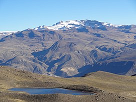
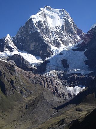
The Apurímac River rises from glacial meltwater of the ridge of the Mismi, a 5,597-metre-high (18,363 ft) mountain in the Arequipa Province in the south-western mountain ranges of Peru, 10 km (6.2 mi) from the village Caylloma, and less than 160 km (99 mi) from the Pacific coast. It flows generally northwest past Cusco in narrow gorges with depths of up to 3,000 m (9,800 ft), almost twice as deep as the Grand Canyon, its course interrupted by falls and rapids. Of the six attempts to travel the full length of the Apurímac so far, only two have been successful.
Bhote Koshi in Nepal and Poiqu in Tibet is the name given to the upper course of the Sun Kosi river. It is part of the Koshi River system in Nepal.
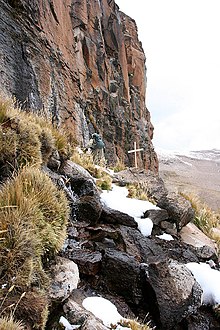
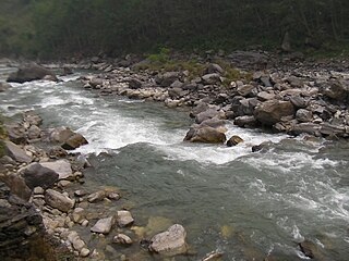
The Carhuasanta is a small river located in the Arequipa Region of Peru. It is known as the headwaters of the Amazon River. The brook is fed by the winter snows of Nevado Mismi, (5,597 m), some 6,400 kilometers from the Atlantic Ocean. Of all the possible river sources in the Amazon Basin, it is the snow melt of the Carhuasanta that has been calculated by cartographers to be one of the furthermost water sources from the mouth of the Amazon.

The Mantaro River is a long river running through the central region of Peru. Its Quechua name means "great river". The word "Mantaro" may be a word originally from the Asháninka language, who live downstream along the Ene River. The Mantaro, along with the Apurimac River, are the sources of the Amazon River, depending on the criteria used for definition.

This is a timeline of Amazon history, which dates back at least 11,000 years ago, when humans left indications of their presence in Caverna da Pedra Pintada.

The main source of the Amazon River, the largest river in the world by discharge, has been a subject of exploring and speculations for centuries and continues to cause arguments even today. Determining the origin of the Amazon River has evoked broad debates among scholars, explorers, and travelers all over the world. Different definitions of a river's source have been used and continue to be used. Generally, four main criteria can be applied to determine the main source of a river: source flow rate, source length, watershed area of the source, and an altitude of its spring. At present, the Amazon River is not considered to have one unique source but a number of headstream areas. These are headwaters of three different Peruvian rivers that can be found in the high Andes: the Marañón, the Apurímac, and the Mantaro.

Quehuisha, Quehuicha, Queshihua, or Quihuisha is a mountain in the Chila mountain range in the Andes of Peru, about 5,514 metres (18,091 ft) high. It is located in the Arequipa Region, Caylloma Province, Lari District, west of the mountain Mismi.

Surihuiri, Sorehuire or Surihuire is a 5,506-metre-high (18,064 ft) mountain in the Chila mountain range in the Andes of Peru. It is located in the Arequipa Region, Caylloma Province, in the districts Lari, Madrigal and Tapay. Surihuiri lies north of the Colca River, northwest of the mountains Mismi, Quehuisha and Jatunpila and south of Minaspata. Some of the nearest villages are Tambomayo and Surihuire.

The Danube is conventionally taken to be formed by the confluence of the two streams Brigach and Breg just east of Donaueschingen. The source of the Donaubach, which flows into the Danube, in the park of Donaueschingen Palace is often referred to as the source of the Danube (Donauquelle). Hydrologically, the source of the Danube is the source of the Breg as the larger of the two formative streams which rises near Furtwangen.
The Hatun Wayq'u which downstream successively is named T'uruyunka(Toroyunca) and Chuqisayra(Choquesayra) is a river in Peru. It is located in the Cusco Region, La Convención Province, Vilcabamba District. It belongs to the watershed of the Apurímac River, the source of the Amazon River.
The Nupe is a small river in the Huánuco Region in Peru. It rises in the Cordillera Huayhuash and joins the Lauricocha River forming what is then called the Marañón River, one of the two largest upstream contributors to the Amazon River. The headwaters of the Nupe have been proposed as one of the sources of the Amazon.