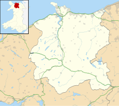
Moelfre is a hamlet in the community of Llanfair Talhaiarn, in the county borough of Conwy, North Wales, close to Abergele (3 miles north), Betws yn Rhos (4 miles west) and Llanfair Talhaiarn (3 miles south).
A commercial fishing pond, some small places of accommodation, a small independent beer and mead brewery, a handful of farms and a logging enterprise are located in the region.
There are no shops or amenities nearby (the closest being a petrol station and garage at Pentrefail Crossroads, 1 mile west, which provides basic foodstuffs for tourist campsites and locals in the area). A public house once located in Moelfre closed a few years ago and is now a large residential property.
Running through Moelfre is the Roman road that was heavily used by Roman soldiers during the Welsh occupation. From the road Moelfre Isaf, a large hill (1040ft) with views of Snowdonia, can be reached on foot.
A hoard of Bronze Age axe-heads has been found on Moelfre Isaf and the hill was used for the lighting of a beacon (as part of a chain of other high places throughout Wales) to celebrate the marriage of Prince Charles and Lady Diana in 1981.
Wild animals and birds are varied in the woodland and groups of wild deer are sometimes seen in the copses near Moelfre at night.
Related Research Articles
Llandovery is a market town and community in Carmarthenshire, Wales. It lies on the River Tywi and at the junction of the A40 and A483 roads, about 25 miles (40 km) north-east of Carmarthen, 27 miles (43 km) north of Swansea and 21 miles (34 km) west of Brecon.
Meifod, formerly also written Meivod, is a small village, community and electoral ward seven miles (11 km) north-west of Welshpool in Montgomeryshire, Powys, Wales, on the A495 road and located in the valley of the River Vyrnwy. The River Banwy has a confluence with the Vyrnwy approximately two miles (3.2 km) to the west of the village. The village itself had a population of 317. The community includes the village of Bwlch-y-cibau and the hamlet of Allt-y-Main.
Cwmtwrch is a village in the valley of the Afon Twrch, a right-bank tributary to the Swansea Valley, Wales, some 15 miles north of Swansea. It is also the name of an electoral ward to Powys County Council.
Moelfre ( ) is a village, a community and, until 2012, an electoral ward on the north-east coast of the Isle of Anglesey in Wales. The community area covers the village and harbour, and several smaller, dispersed settlements. It includes six scheduled Iron Age hut groups and many other sites of archaeological interest. The harbour was formerly a local fishing port; a lifeboat station has been based here since 1854. Among many shipwrecks off the coast was that of the Royal Charter in 1859. Near the modernised lifeboat station is the RNLI Seawatch Centre. The coastline includes a rocky headland north of the village and a large sandy beach at Lligwy Bay, both traversed by the Anglesey Coastal Path. The 2011 census measured the village population as 710. It was estimated at 614 in 2019.
Llangernyw ( ) is a rural, mostly Welsh-speaking, village and community in Conwy County Borough, North Wales.
The River Elwy is a river in Wales forming a tributary to the River Clwyd. Though the source of the river may be on the northern flank of Moel Seisiog, south-east of Llanrwst, the river only receives the name Elwy at the village of Llangernyw, where three rivers meet.
Llanvair Discoed is a small village in Monmouthshire, south-east Wales, 6 miles west of Chepstow and 10 miles east of Newport.
Sarn Helen refers to several stretches of Roman road in Wales. The 160-mile (260 km) route, which follows a meandering course through central Wales, connects Aberconwy in the north with Carmarthen in the west. Despite its length, academic debate continues as to the precise course of the Roman road. Many sections are now used by the modern road network while other parts are still traceable. However, there are sizeable stretches that have been lost and are unidentifiable.
The Isle of Anglesey County Council is the local authority for the Isle of Anglesey, a principal area with county status in Wales. Since 2022 the council has 35 councillors who represent 11 multi-member electoral wards.
Llanfair Clydogau is a small village and community encompassing 3,232 hectares, located about 4 miles (6.4 km) north-east of Lampeter on the B4343 road, in Ceredigion, Wales. It has a population of 634 as of the 2011 UK census, 87.5% of whom are Welsh-speaking, yet only 46% were born in Wales?. Formerly located within the hundred of Moyddyn.
The rectangular enclosure that defined this Roman fort was built in the 70s AD as part of the campaign to integrate southern Wales into the Roman province of Britannia Superior. It lay on a key road, now known as the Sarn Helen (RR69), from the legionary fortress of Isca Augusta (Caerleon) that ran north west across Wales to Bremia and on to North Wales. It also sat on a road running from Moridunum (Carmarthen) across to eastern Wales at Castell Collen. It thus held an important crossroads along with a bridging point over the River Towy, and the town that grew up near the fort retained its significance and became Llandovery.
John Jones, known by his bardic name of Talhaiarn, was a Welsh poet and architect.
Moelfre Isaf is a 317-metre (1,040 ft) hill located to the south of the town of Abergele. There are views towards the Clwydian Range, Snowdonia, and the Isle of Man and the Cumbrian Mountains can be seen on a clear day. Nearby is the small settlement of Moelfre, Conwy. Almost opposite is the higher hill of Moelfre Uchaf.
Llanfair-y-bryn is a community and Church in Wales parish in Carmarthenshire, Wales. Covering an area of some 95 km², it lies along and to the northwest and southeast of the A483 Swansea to Chester road immediately north of the town of Llandovery. The population of the community at the 2011 census was 624. The term also referred to a church located outside the parish.
Llanfair Kilgeddin is a small village in Monmouthshire, south east Wales, lying within the administrative community of Llanover. It is located four miles north west of Usk and six miles south east of Abergavenny on the B4598 road. The River Usk passes close by.
Llanfair Talhaiarn, abbreviated to Llanfair TH, is a village and community approximately 5 miles (8.0 km) south of Abergele in Conwy county borough, Wales. Until 1974 it was included in Denbighshire. The population was 979 in 2001, increasing to 1,070 at the 2011 census with 44% being Welsh language speakers.
Anglesey is an island off the north-west coast of Wales. It forms the bulk of the county known as the Isle of Anglesey, which also includes Holy Island and some islets and skerries. The county borders Gwynedd across the Menai Strait to the southeast, and is otherwise surrounded by the Irish Sea. Holyhead is the largest town, and the administrative centre is Llangefni. The county is part of the preserved county of Gwynedd. Anglesey is the northernmost county in Wales.
Llanfairpwllgwyngyll or Llanfair Pwllgwyngyll, often shortened to Llanfairpwll and sometimes to Llanfair PG, is a village and community on the Isle of Anglesey, Wales. It is located on the Menai Strait, next to the Britannia Bridge. At the 2011 Census the population was 3,107, of whom 71% could speak Welsh. In 2021, the population decreased to 2,900. It is the sixth largest settlement in the county by population.
Upper Chapel is a hamlet in the southern part of the county of Powys in mid Wales. It was formerly in the county of Brecknockshire. It lies on the B4520 road from Brecon to Builth Wells, in the valley of the River Honddu. The south-flowing Honddu cuts deeply into the uplands of Mynydd Epynt north of Brecon. To the north and west of Upper Chapel lies the British Army's Sennybridge Training Area.
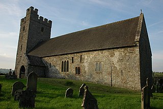
St Mary's Church is a Church in Wales place of worship near Llandovery, Carmarthenshire, Wales. It was formerly the parish church of Llanfair-ar-y-bryn but was replaced in that function by a new church in a more central location. The present building dates from the 12th century. It has a large churchyard and is situated on a small hill to the north of the town. It was designated a Grade I listed building on 3 August 1966.
This page is based on this Wikipedia article Text is available under the CC BY-SA 4.0 license; additional terms may apply. Images, videos and audio are available under their respective licenses.